
By Ted Grussing
… the beauty of this shot looking up Sycamore Canyon from about 7,000’ and a few miles south of the confluence of the Verde River and Sycamore Creek. I took this shot yesterday morning after exploring the clouds further north and although they had not developed vertically more than a thousand or so feet, they were working pretty good up to base of about 8500’. Went on top for a while and enjoyed the view. Then it was down to shoot Sycamore Canyon and get some very inclusive shots of the whole area; having been there on the ground now gave me a better idea of what I wanted to shoot.
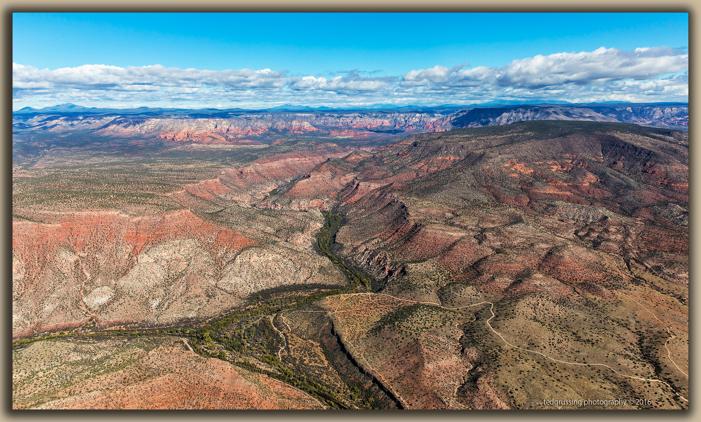
So here we go!!! Starting on the lower left side, The Verde River makes its appearance and it is flowing from left to right. Sycamore Creek joins the Verde River in the lower left quadrant and the combined flow continues to the right and drops out of the image about lower mid image. The road coming in from the lower right side is the road I drove there a week ago today and you get on it by turning left after you cross the Verde River down by Tuzigoot, about eleven miles to the right. The road enters an overlook where you can park and the start of the Dawson Trail is there. Looks like some other roads you can come off the bluff and get down to the river – probably jeep only. The road in looks deceptively good … it is not! The roads down from the observation areas do not look good … they are likely nasty.
The overlook is well below the canyon walls and you cannot see much beyond the first turn to the left going up the canyon. To the left of the lookout area are the rock formations I used for One in the Halloween composite this past week. Continuing up the canyon you can see the wide expanse of the canyon further into it. There is still a deep ravine that the creek follows. But it is more expansive. And above center you can see the red rock formation I like to shoot from overhead; about ten miles up from where I took this. The plateau continues left to the NW to Ash Fork and Bill Williams mountain is horizon on the left. To the right of it is Sitgreaves Mountain, then Kendrick, the base of the SF Peaks which are wreathed in clouds and finally Mt. Elden. Coming up from the bottom of the image on the right side is Black Mountain and above it Casner Mountain – both are flat topped mountains.
Anyhow, hope you enjoy the photo and have a good start to your week. Flying down to Prescott in the morning to have some avionics calibrated and a flight somewhere after that before returning to Sedona … not sure where :+) Have a beautiful day and smile … we’re here!
Cheers
Ted
I am the dawn, the whisper of winds, the perfume of morning.
The passing night fondled me, hovering close to me, softly, silently.
The breaking day builds the spirit temple of my joy, I abandon myself!
I see all as one, and nothing repels me, as this new day climbs noiselessly out of the valley of the night.
Peace lies over the world and over the world of my soul.
— Max Ehrmann
###
The easiest way to reach Mr. Grussing is by email: ted@tedgrussing.com
In addition to sales of photographs already taken Ted does special shoots for patrons on request and also does air-to-air photography for those who want photographs of their airplanes in flight. All special photographic sessions are billed on an hourly basis.
Ted also does one-on-one workshops for those interested in learning the techniques he uses. By special arrangement Ted will do one-on-one aerial photography workshops which will include actual photo sessions in the air.
More about Ted Grussing …