
By Ted Grussing
The TFR over the Slide Fire area was lifted yesterday [June 6, 2014] late afternoon; this morning [June 7] I went up there to get some more images of the burn area from a lower altitude and tomorrow morning I’ll be doing the same. I had some requests for a photo from near the top of West Fork and the first image [below] Is a shot from about two thirds of the way up the canyon looking down canyon towards the juncture with Oak Creek Canyon. The east wall of Oak Creek Canyon runs from left to right ( I suppose right to left would work too) near the top of the image.
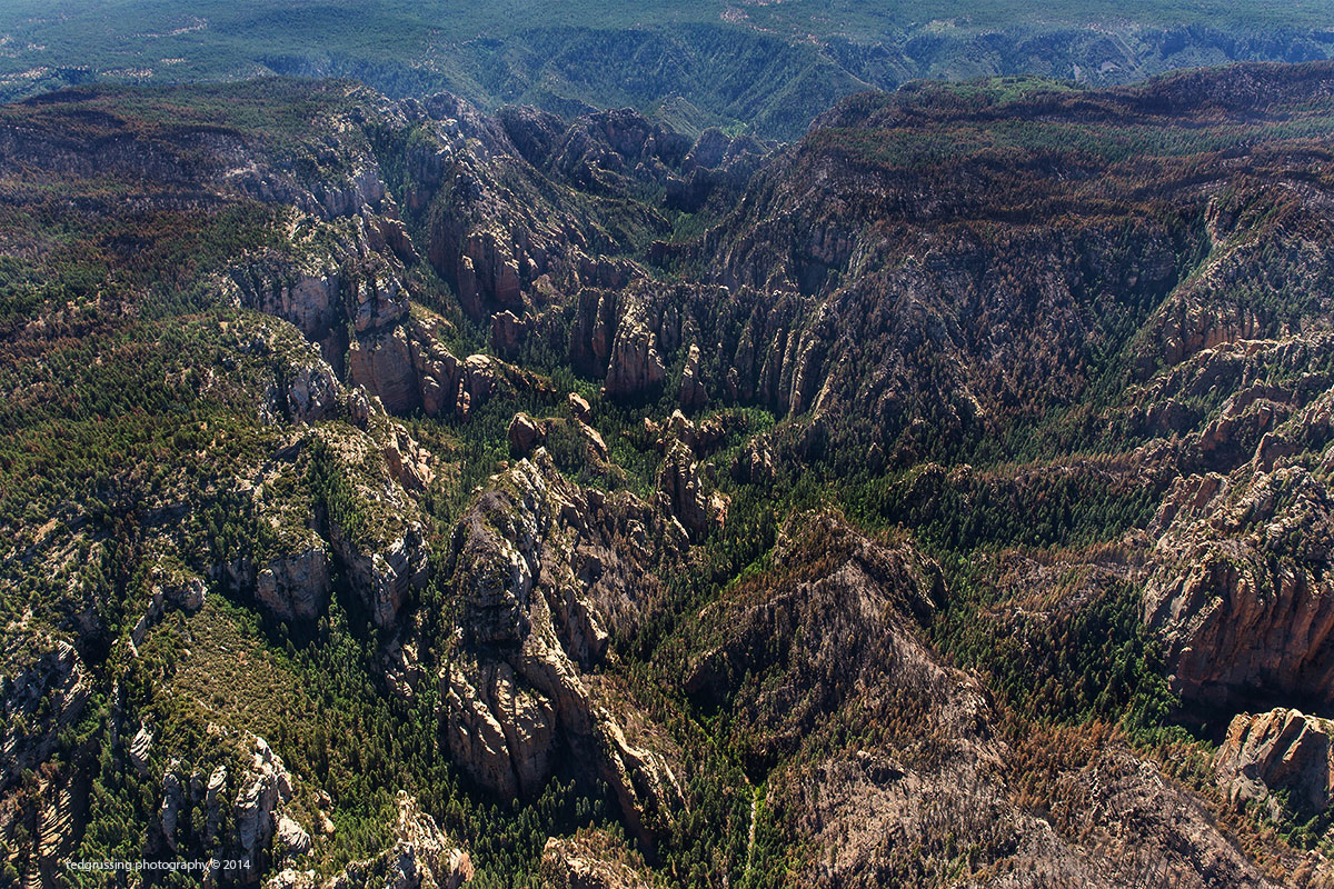
The creek in West Fork wends its way from near bottom center to the top along the canyon floor. The entire length of the canyon the area around the creek appears to be in very good shape and is a lush green, many of the canyon walls did not fare as well. On the plateau either side of West Fork you can see the areas which had high intensity fires; the first quarter mile or so of West Fork appears to be in pretty good shape too and the area behind me is in quite good shape going to the top of West Fork. Happy to provide anyone photos of the exact point you are interested in; took nearly a thousand photos yesterday and today and more tomorrow. The view in this photo is to the East.
The [second photo, below] was shot from approximately over the switchbacks where SR 89A comes up out of Oak Creek Canyon looking towards the SSE. Oak Creek Canyon is on the left and at the top both East and West canyon walls are in good shape. West Fork enters Oak Creek Canyon from the bottom right of the image and as you can see the first part of West Fork is in pretty good shape; the fire appears to have gotten into West Fork from the top where it came up on top from the West Wall of Oak Creek Canyon, ran across the top of the plateau and dropped down into West Fork. From Slide Rock State Park going North most of the way to West Fork the West wall of Oak Creek Canyon was completely burned out. Going down the canyon Wilson Mountain is on the end on the right and beyond that and to the right the City of Sedona and above the burned plateau on the right side of the image Long Canyon is just below where the plateau drops off … Enchantment Resort is tucked in Boynton Canyon in the formations just above the plateau on the right. Mingus Mountain is on the horizon with Jerome on the side and Cottonwood at the base.

Of note, Oak Creek Canyon is an earth quake fault line as well as a beautiful canyon eroded by the flow of water through it. You can see the left part of Wilson Mountain is several hundred feet lower than the main part; this is where an earth quake or a series of them sheared the volcanic cone into about 1/3-2/3 portions dropping the 1/3 part several hundred feet and moving it about ¼ mile to the SE. The planet is ever changing, seldom in ways we want … we get used to the status quo and then we have to adopt again.
Personal comment: I have no idea why the USFS permits any campfires in the National Forests … with alcohol and propane stoves readily available, food can be cooked easily, safely and efficiently with minimal danger of starting a forest fire. This fire was human caused and possibly a camp fire that got away … fire restrictions were in place at the time this fire was started. A total ban of camp fires would cause little inconvenience compared to the cost of the one that got away. You have all the ambiance you need just being out in the forest … my two cents worth.
Have a terrific weekend … share your joy … a few smiles will do the trick.
Cheers
Ted
With all its sham drudgery and broken dreams, it is still a beautiful world.
Be careful. Strive to be happy.
— Max Ehrmann
###
The easiest way to reach Mr. Grussing is by email: ted@tedgrussing.com
In addition to sales of photographs already taken Ted does special shoots for patrons on request and also does air-to-air photography for those who want photographs of their airplanes in flight. All special photographic sessions are billed on an hourly basis.
Ted also does one-on-one workshops for those interested in learning the techniques he uses. By special arrangement Ted will do one-on-one aerial photography workshops which will include actual photo sessions in the air.
More about Ted Grussing …