By Mark TenBroek
Sedona, AZ — As of March, 2023 the Sedona Trailhead Shuttle has been running for over a year and has been successful in gaining ridership primarily from visitors to our community. First it is important to understand what the objective of the Trailhead Shuttle is:
- Make it easier for residents and visitors to get to popular trailheads in a safe and sustainable way
- Protect the fragile environment around trailheads by reducing the number of vehicles
- Reduce parking in neighborhoods near trailheads
- Reduce danger to pedestrians and traffic safety around key trailheads – Cathedral Rock, Soldiers Pass Trail, Dry Creek, Mescal, Little Horse
Note that the Trailhead Shuttle was originally envisioned as starting 2 to 3 years from now, but clearly much of the impetus for the Trailhead Shuttle deployment a year ago was from the last two items – to address high trailhead use in both the Soldiers Pass and Back O’Beyond neighborhoods that have limited trailhead parking lots which has caused conflicts with residents. Lots of visitors circling searching for parking wherever they can find it. In addition to these two neighborhoods, the Trailhead Shuttle also was working to address the high use at the Dry Creek Vista (Devil’s Bridge) trailhead on the west side of Sedona.
It is also important to note that the eventual transit system in Sedona will also include fixed route and demand response (Microtransit) components when the entire system is eventually rolled out. Transit in our relatively small unique community will take time to build, develop ridership, and adjust over time.
Ridership Limits
The US Forest Service (USFS) establishes trailhead parking limits to meet their understanding of the hiker need at trails throughout the National Forest. For the Shuttle operation, the Soldiers Pass and Cathedral Rock parking lots were closed during the operation of the shuttle, but Dry Creek Vista and Mescal remained open during these operations. In the case of the Trailhead Shuttle, the USFS set upper limits on the number of additional hikers that the Trailhead Shuttle can deliver to individual trailheads and returning them back to their parking location:
Trailhead Daily Round Trips
- Cathedral Rock 600
- Dry Creek Vista 500
- Little Horse 500
- Mescal 300
- Soldiers Pass 300
- TOTAL 2,200
The Trailhead Shuttle currently operates 4 days a week (Thursday – Sunday), except during the spring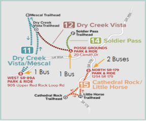 vacation months when they offer 7 days a week operations. This year round operation is due to a contract with the operator, the fixed costs of the equipment, and the need to retain trained drivers in a limited employment market.
Parking is provided at three locations. A first lot is located at the High School on SR 89A and Route 11 runs to both the Dry Creek Vista and Mescal trailheads. A second bus runs Route 12 from the Posse Grounds to both the Dry Creek Vista trailhead and Route 14 to the Soldiers Pass trailhead. Two additional buses on Route 15 run a loop from the SR 179 lot, Cathedral Rock, Little Horse, and back to the lot. All of these routes are shown in the figure, from the City website.
First Year Ridership
None of these routes extend into the “Y” to reduce the possibility of delays due to traffic. The boardings and departures at each of the stops has been tracked for each trip and the results of the ridership activity is shown in the following graph showing the number of roundtrips that have been ridden throughout March 2022 through April 1, 2023. A number of major holiday periods have been included on the graph to show when peak activity takes place.
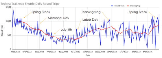
The blue line on this graph shows daily round trip ridership that has exceeded 1,000 round trips during the Spring Break periods to lower ridership of about 350 round trips during the summer months. The more significant variability in daily round trips in December through February were caused by a number of rainy and snowy days that took place impacting access to many of these trails. The red line is a 15-operational day moving average of the total ridership to better understand how ridership approached the USFS limits.
Day of the Week Ridership
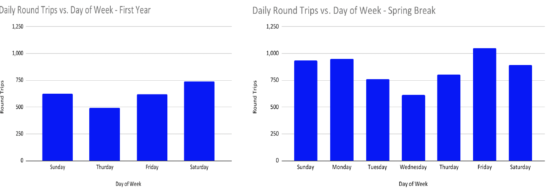
The Trailhead Shuttle was set up to meet the peak visitor need around weekends. The first graph below shows how the ridership varied by day of the week throughout the year. The second graph shows how the ridership varied during the Spring Break periods.
As expected, the higher ridership is during the weekend periods, with Saturday being the highest ridership day during the year and Friday being the highest ridership day during Spring Break. It suggests that this ridership may be most influenced by those that drive up for a single day in Sedona.
Ridership by Route
The ridership throughout the year on each route can also be reviewed. The following graph shows the total number of round trips to each of the different trailheads that are served. As expected, the Cathedral Rock trailhead experienced the most traffic with over half of the total round trips at about 80,000 for the year. The Soldiers Pass route had more than 35,000 round trips, mainly because it is a short route of about a mile each way and is in high demand.

The Little Horse and Mescal trailheads had significantly less traffic, likely because they already had available roadside parking that remained open during peak periods. The Dry Creek Vista did gain ridership over the monitoring period, and this was likely due to the high demand of the Devil’s Bridge hike as well as steps taken by the City to limit roadside parking inside City limits, as well as longer walks to access the trailhead as roadside parking filled during peak periods.
Trailhead Shuttle Costs
The cost of the Trailhead Shuttle is dependent on several cost components. First was the purchase of the 5 buses that are used for the Trailhead Shuttle, with a total capital cost of $710,125 that is spread over the expected life of the vehicles, about 7 years. This results in a monthly cost of about $8,454 per month. At the end of this period, the buses are expected to have minimal resale value given their high mileage.
A second cost category is the fixed cost of the contractor operating the vehicles. This includes management, maintenance, insurance, and other fixed costs. These amount to $752,000 annually, which are split into monthly payments of $62,651. It is important to note that this total cost will eventually cover the cost of the fixed route shuttle and the Microtransit, scheduled to start later this year. This will reduce the fixed cost allocated to the Trailhead Shuttle and reduce its overall operational costs.
A third cost are the Vehicle Revenue Hours (VRH), or the hours that the units begin operations receiving hikers until they suspend operations at the end of the day. This is a transit term as normally transit payments are received for transit use, but since Sedona pays the full cost of these operations these reflect bus operational hours.
A final cost term is the actual fuel costs that the buses use while transporting hikers, training operators, or driving the vehicles to maintenance. Overall, the summary of the monthly costs for the Trailhead Shuttle is shown in the following chart. The average monthly cost of the shuttle is slightly over $110,000/month.

Round Trip Costs
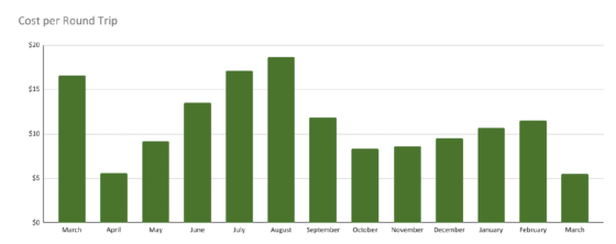
Based on the ridership and the total costs shown above, the average cost by round trips can be calculated for each month of operation. The following chart shows the composite cost per round trip for the Trailhead Shuttle from the beginning of operations in March 2022 until April 1, 2023.
As expected, the cost per round trip is less during the busy Spring Break periods when average round trips for all routes are slightly over $5 and higher at about $18 per round trip during the summer months when ridership is lower.
Route Costs
This cost for each of the different routes can also be calculated, as shown in the following graphic. This graphic shows, as expected, that the shortest route, Soldiers Pass, is also the lowest cost at slightly over $2 per round trip given its high ridership. This is also the location where the City recently constructed both a parking lot for hikers and a multi-use path to access the Soldiers Pass trailhead. 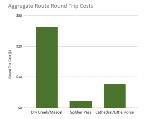
Cathedral Rock is in the middle at about $8 per round trip given the high ridership and intermediate length of the shuttle route. Finally, the Dry Creek Vista and Mescal routes show higher costs of around $26 per round trip due to their longer runs and lower use. This lower use is likely due to the significant amounts of currently available roadside parking near these trailheads that can lead hikers to opt for more flexibility and drive to locations near the trailhead.
Sustainability
One of the reasons for the Trailhead Shuttle is to provide a way to access the trailheads that put more hikers in vehicles with more capacity and reduce the number of vehicles on the roadway and that attempt to park near the trailhead. One way to do this is to calculate the amount of carbon dioxide generated by the Trailhead Shuttles and compare this to the use of the passenger vehicles that the hikers most likely already have in Sedona.
The total fuel volume used by the Trailhead Shuttles was used to estimate the Carbon Dioxide they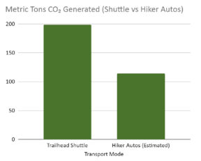 produce as in the graphic. It is important to note that this includes all shuttle operations so that a system carbon generation amount is provided.
To compare auto carbon generation, the calculation assumes each hiker automobile moves 3 hikers from the shuttle parking and travels the same distance as the Trailhead Shuttle to the trailhead using the average US fuel economy (22 MPG) to estimate the amount of Carbon Dioxide generated. While this graphic suggests that in terms of reducing Carbon Dioxide the Trailhead Shuttle may not reduce the Carbon Dioxide generated in the City, it does have a significant impact on reducing automobile congestion at the trailhead locations since adequate parking is in short supply.
Reduced Traffic Congestion
One of the items not included in the Trailhead Shuttle rationale is that of reducing traffic congestion in Sedona. This particular item is a key concern to many Sedona residents and businesses. It should be pointed out that with a maximum 1,000 round trips being provided by the Trailhead Shuttle, this relates to about 333 vehicles (using 3 hikers per vehicle) that are diverted from the Trailhead parking on a peak day. This may be compared to the estimated daily 16,000 cars present in Sedona during a peak period. However, it is also likely that most of these hikers are coming back from their hikes between the early afternoon to 5:00, precisely the same time that traffic is likely peaking in Sedona.
So does this mean that the Trailhead Shuttle is an ineffective strategy for managing traffic in Sedona? It is important to consider that the entire transportation system, including SIM improvements, the upcoming fixed route transit, and Microtransit need to be deployed to better answer that question. Providing residents and visitors with options like transit, safe bikeways and controlled parking in town and near trailheads are all components of a system that will help to reduce the focus on driving to locations in and around Sedona that add to the congestion that the community already is experiencing. In other words, it is too early to tell and it will take time to allow the overall transportation systems upgrades and modifications to operate and generate data on how they will best be operated.
Peak Tourism Management
A final item that needs to be considered is whether the use of the Trailhead Shuttle may direct too many hikers to trails that cannot reasonably accept the additional load without being degraded. This concern has already been raised by some that use these trails serviced by the Trailhead Shuttle. This is the specific reason the USFS placed limits on the total round trips that the Trailhead Shuttle could provide to different locations.
To protect the overall trail system in and around Sedona the number of hikers that are given access to these trailheads may need to be monitored and adjusted in the future. Once parking in areas with excessive amounts is controlled, the Trailhead Shuttle may be a useful tool to limit the number of hikers that access the trails where hiking pressure is too high, acting as a trail reservation system of sorts.
However, it also remains to be seen if private enterprise, in the form of say Uber, will cause an unintended consequence and bring more hikers to locations that cannot be supported. That is why the use and adjustment to the Trailhead Shuttle ridership may be an effective tool in managing peak visitation in Sedona to sustainable levels.
Mark TenBroek
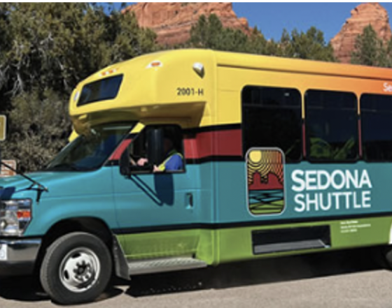
Credit to the Sedona Transit website and Mr. Robert Weber for the Shuttle photo, the trailhead shuttle route map, and the underlying ridership and cost information.
Editor’s Note:
Mark is a retired Professional Civil Engineer who graduated from the University of Michigan in 1977 and worked as a consulting and design engineer in the Midwest for over 40 years. He worked primarily on Water and Wastewater projects for municipalities and utilities. He and his spouse arrived in Sedona in 2017 to design and build a home in Uptown where they now live. Mark is very interested in understanding how things work using available data sources and by collecting new supporting information. He continues to work on understanding and writing about Sedona and how the local economy can be managed to provide a livable community while businesses can prosper. He understands Sedona’s unique place as both a sacred and spiritual center. Researching how the local economy can be effectively managed to protect our quality of life, the natural world, the tourist experience, and reasonable profits for local businesses, has become his passion.



7 Comments
Thank you for this detailed analysis. I was unaware that USFS had placed limits on the number of hikers on any given trail by controlling the # of shuttle trips. I believe the Volpe Institute received a grant to come to Sedona this coming Sept. to evaluate some of the challenges we are experiencing.
VERY GOOD REPORT EXPLAINING SO MANY ANGLES. THANK YOU. I THINK I UNDERSTOOD ABOUT 95% AND WAS SURPRISED ABOUT THE CARBON COMPARISONS. LIVING BY BACK O’BEYOND RD. IT HAS MADE A HUGE DIFFERENCE IN
CONGESTION, AND CAR AND FOOT TRAFFIC.
The analysis is pretty good, and can be added to the previous article(s) in the RRN regarding the cost benefit.
Questions I have asked multiple times – never an answer.
1: Why is it FREE to tourists? Go on any vacation anywhere, you you pay something for transportation. When we interviewed tourists last year in Spring, they thought the service was great, and could not believe it was free. Neither could we. You have people coming here from all over, spending $100s if not thousands of dollars on vacations and you can’t charge for a transportation service? This is an app based system, put a $5 charge per family or something. It does not have to be 100% accurate, but it could help offset these costs, which are only going to grow. Even at the Airport overlook, the $3 parking fee per car pays for the maintenance and improvements that are up there. A council flush with tax money tends to ignore common sense.
2: The city is finally doing something about the flooding on Back O Beyond road. They are putting in a culvert at the highest water crossing, between SR179 roundabout and the Cathedral trailhead – at a cost of $849,000. Will that help the residents on Back O Beyond Circle who live BELOW the trail head? Nope. There are two water crossings past the trail head the are 5X as severe as the one they are fixing. At least tourists can get to the trial head when things flood. Staff says that this is the first of the Back O Beyond repair, which has been a issue for decades.
3. There was talk in this article about pedestrians accessing trailheads. We see everything from couples to groups of 5 to 8 people walking down Back O Beyond road from SR179. They are parking in the parking area on SR179 and walking. There is not enough room barely for two cars on Back O Beyond let alone pedestrians. Just waiting for someone to get run over. And “No pedestrian allowed” signs? Those are about as effective as they are on airport road, which is another city owned road with as critical pedestrian issue.
There was an interesting analysis on the Shuttle system and the percent of ridership per trip in the Red Rock News not long ago. The outcome was not a stellar success. Throw a little offsetting income in there and it would look a lot better.
Why dont you attend a STAC meeting? They have a wide array of individuals that have volunteered their time to help improve traffic, help people with disabilities and make it easier to get the elderly to dr. appointments. I believe there is even and opening?
I am already a volunteer member of STAC, but thanks for the suggestion.
Thanks for all of the work Mark, but there are some glaring problems with this system and I believe your CO2 emissions estimates are grossly inaccurate.
When the SIM plan first came out, the shuttle parking lots were supposed to be at the high school (I noticed that parking lot was recently added) and at the Forest Station parking lot on 179. Both of those locations would’ve been optimal, but instead the parking lots were built at Posse Grounds and below the Church of the Red Rocks! So hikers that want to hike at Devil’s Bridge, drive in from the 260 and drive past Dry Creek road all the way to Posse Grounds to park and wait for the shuttle; then the shuttle drives hikers back the way they just came to the trailhead, so after their hike they travel back through town, so they can get back in their cars and drive back through town, the same way they drove in to town! How does this make any sense?
The same thing happens for hikers who come in to town on 179, they drive past the trailhead to the parking lot! The only exception is they have the pleasure of sitting in bumper to bumper traffic on every leg of the journey.
Both parking lots had to be built out, which is not included in your initial expense calculations. The original lots would have truly reduced congestion and lowered the CO2 emissions, but instead, there are 4 additional trips! I can only guess that some brain surgeon decided that maybe hikers would be more likely to spend money on dinner, since they were closer to the action, and had to wait for the traffic to die down.
I also agree that it is ridiculous that riders don’t pay a dime for the service. While it appears the City has endless buckets of money, they could pay off the existing debts (instead of servicing the debt) and fix our crumbling infrastructure (sewer system and roads are the first things that come to mind).
And I don’t know about anyone else, but it appears to me the new pathways near Tlaquepaque are a colossal waste of tax money! Especially as they don’t intend to close the crosswalk that is responsible for a huge part of our gridlock! When they built Tlaquepaque North the owners should’ve been forced to build an overpass with elevators for their shoppers, instead of setting aside $65,000 and hoping someone would came up with a solution to the pedestrians crossing. And yes it can be done, google “overpass, Dana Point, CA”. It spans Pacific Coast Highway to keep pedestrians from crossing 6 lanes of traffic.
Just my two cents!
It is pretty hard to comment on your suggested additions to the carbon calculation that was included in the article as there are lots of unknowns about how hikers get to the various parking lots and where they travel to next. I will stick to the assumptions that were included and the conclusions presented.
I will also not comment on the Tlaquepaque crosswalk cost or effectiveness as that was not part of the article scope.
Finally, the overall transit efficacy should be reviewed once all components have been rolled out and we have data on its performance. Thanks.