
By Ted Grussing
… I spent untold hours looking for the best views of the greater Sedona area over the years and this is one of the neatest shots that encompasses nearly everything there is … with the bonus of a good portion of the Verde Valley and mountains beyond. Another nice bonus for the day were beautiful clouds with a a base around11,000′ which allowed for some fun time flying cloud canyons after I got the airscape shots I wanted. I was about 7,500′ when I shot this from a position over the plateau ENE of the Village of Oak Creek where I live and looking WSW over it all.
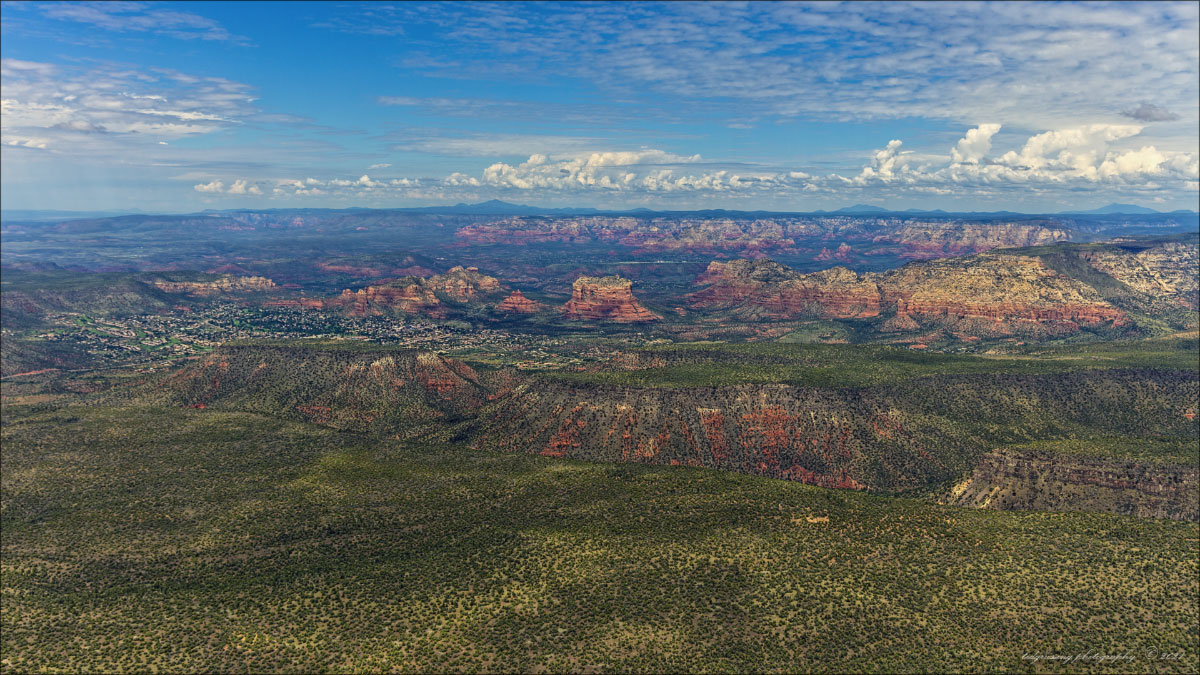
Starting in the foreground is the Colorado Plateau and the first canyon is Woods Canyon; it runs the width of the image and on the other side of Woods Canyon is Jacks Canyon, which includes Pine Valley just before it turns left and up towards the north. The Village of Oak Creek is on the far left side at about mid point from the bottom … you can see the two golf courses nestled in the valley. On the left side of the Village, House Mountain rises … it is about a 15,000,000 year old shield volcano which at one time was part of the rim … the rim has receded about four miles in the intervening years.
SR 179 which heads north from I 17 passes through this photo from left to right with a slight upward slant … you can see it on the left side, mid way up as it heads up towards and through the Village and you can pick it up again as it passes between Castle Rock and Bell Rock, just left of image center. To the right of Bell Rock is Courthouse Rock and straight to the right of it is Lee Mountain, the Rabbit Ears formation and on the far right side beyond the gap after Lee Mountain is Munds Mountain.
Above Lee and Munds Mountains is Wilson Mountain, another mountain of volcanic origin and cutting to the north behind it is Oak Creek Canyon. The whitish line above Courthouse Rock is Airport Mesa and beyond it is West Sedona … on this side, below it is the Chapel area … to the left of the airport is the Loop Road area. Oak Creek runs right to left just below Airport Mesa and through the Loop Road area, State Park, Page Springs, Cornville and eventually ending up at the confluence with the Verde River at about the location of Thousand Trails Campground, just north of SR 260 and east of Cottonwood.
On the left side, below the horizon is Black Mountain, then moving right, the Gap and then Casner Mountain … behind these two mountains and the gap, is Sycamore Canyon. On the horizon from left to right starting left of center is Bill Williams Mountain, near the right side Sitgreaves Mountain and on the right side, Kendrick Peak.
I love this place and all the wonderful people who live here … truly blessed! As you can see, the red rock country is not a huge area … perhaps fifty or so square miles .. you are looking at all of it!
Have a beautiful day … keep breathing and smile … even a slight grin will work.
Ted
###
The easiest way to reach Mr. Grussing is by email: ted@tedgrussing.com
In addition to sales of photographs already taken Ted does special shoots for patrons on request and also does air-to-air photography for those who want photographs of their airplanes in flight. All special photographic sessions are billed on an hourly basis.
Ted also does one-on-one workshops for those interested in learning the techniques he uses. By special arrangement Ted will do one-on-one aerial photography workshops which will include actual photo sessions in the air.
More about Ted Grussing …