

![]() Sedona AZ (June 4, 2014) – FINAL UPDATE – Today: Crews continue to monitor the fire perimeter. While there are no threats to containment, internal areas of unburned fuel may continue to smolder, producing light smoke.
Sedona AZ (June 4, 2014) – FINAL UPDATE – Today: Crews continue to monitor the fire perimeter. While there are no threats to containment, internal areas of unburned fuel may continue to smolder, producing light smoke.
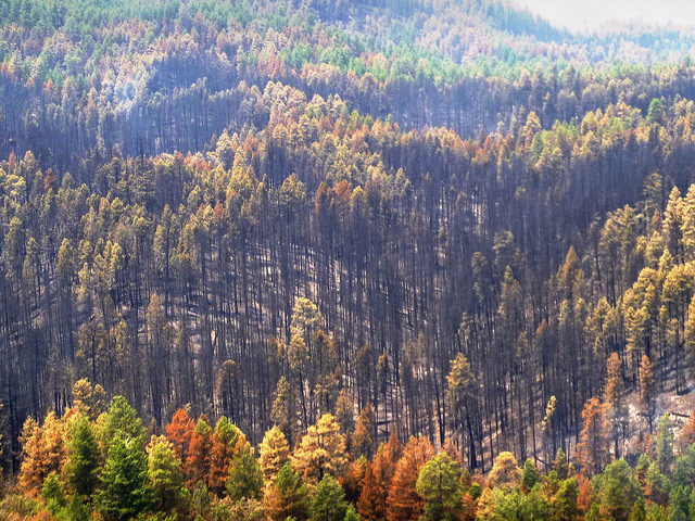
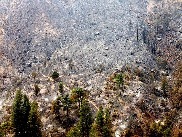
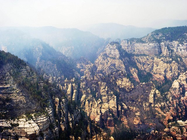
New Fire Videos: View a post-fire flight down West Fork and along Highway 89A: http://tinyurl.com/k2xa8qg
New Interactive 3D Fire Map: Visit http://tinyurl.com/kc4w6pf and download the file. Note:You need to have Google Earth open on your computer before opening these layers. To install Google Earth visit: http://google.com/earth
Size: 21,227 acres
Containment: 100 Percent
Date Reported: Tuesday, May 20 at approximately 4 p.m.
Cause: Human caused, under investigation.
Cost: 10.1 million dollars.
Forest Closure: Many areas within Oak Creek Canyon remain closed to the public. The Coconino National Forest has issued an emergency closure on all National Forest System lands within the area of the Slide Fire on the Coconino National Forest, in Coconino and Yavapai Counties. To view the Order and map of the fire closure area, visit: http://tinyurl.com/mzja5rd
Closed Roads: Highway 89A will remain closed from the Pine Flats campground north to the entrance of the overlook at the switchbacks. The ‘overlook’ is open to the public.
###
![]() Sedona AZ (June 3, 2014) – UPDATE – Yesterday: Within the controlled fire perimeter, areas of unburned fuel produced a small flare up in the afternoon in the Howard Pocket area. The flair up was far within the interior of fire containment lines. No new fire spread is expected outside the existing fire perimeter.
Sedona AZ (June 3, 2014) – UPDATE – Yesterday: Within the controlled fire perimeter, areas of unburned fuel produced a small flare up in the afternoon in the Howard Pocket area. The flair up was far within the interior of fire containment lines. No new fire spread is expected outside the existing fire perimeter.
Today: Crews will continue to monitor the area throughout the day and additional helicopter work may be necessary. Other internal areas of unburned fuel may continue to smolder, producing light smoke. Crews on all areas of the fire perimeter will continue rehabilitation efforts.
Additionally, the Burned Area Emergency Response (BAER) Team continued work to address emergency situations resulting from the wildfire such as the potential for increased flooding and mud and/or debris flows. For more information on BAER please visit: http://inciweb.nwcg.gov/incident/3884/
Size: 21,227 acres
Containment: 92 Percent
Date Reported: Tuesday, May 20 at approximately 4 p.m.
Cause: Human caused, under investigation.
Current Resources: Approximately 145 personnel.
Cost: 9.9 million dollars.
Forest Closure: Many areas within Oak Creek Canyon remain closed to the public.The Coconino National Forest has issued an emergency closure on all National Forest System lands within the area of the Slide Fire on the Coconino National Forest, in Coconino and Yavapai Counties. To view the Order and map of the fire closure area, visit: http://tinyurl.com/mzja5rd
Forest Restrictions: The Coconino and Kaibab National Forests continue Stage II fire restrictions that went into effective Friday (5/30) at 8 a.m., for additional information please visit Arizona Fire Restrictions http://firerestrictions.us/az/.
Closed Roads: Highway 89A will remain closed from the Pine Flats campground north to the entrance of the overlook at the switchbacks. The ‘overlook’ is open to the public.
Air Quality: For information on air quality, please visit the Arizona Department of Environmental Quality website at: http://www.phoenixvis.net/PPMmain.aspx
###
![]() Sedona AZ (June 2, 2014) – UPDATE – Yesterday: Within the controlled fire perimeter, areas of unburned fuel produced a small flare up in the afternoon near Junipine Resort. Helicopters were used for water bucket drops on the steep and rugged canyon walls in this area. No new fire spread is expected outside the existing fire perimeter.
Sedona AZ (June 2, 2014) – UPDATE – Yesterday: Within the controlled fire perimeter, areas of unburned fuel produced a small flare up in the afternoon near Junipine Resort. Helicopters were used for water bucket drops on the steep and rugged canyon walls in this area. No new fire spread is expected outside the existing fire perimeter.
Today: Crews will continue to monitor the area throughout the day and additional helicopter work may be necessary. Other internal areas of unburned fuel may continue to smolder, producing light smoke. Crews on all area of the fire perimeter will continue rehabilitation efforts.
Size: 21,227 acres
Containment: 90 Percent
Date Reported: Tuesday, May 20 at approximately 4 p.m.
Cause: Human caused, under investigation.
Current Resources: Approximately 200 personnel.
Cost: 9.8 million dollars.

Forest Closure: Many areas within Oak Creek Canyon remain closed to the public. The Coconino National Forest has issued an emergency closure on all National Forest System lands within the area of the Slide Fire on the Coconino National Forest, in Coconino and Yavapai Counties. To view the Order and map of the fire closure area, visit: http://tinyurl.com/mzja5rd
Forest Restrictions: The Coconino and Kaibab National Forests continue Stage II fire restrictions that went into effective Friday (5/30) at 8 a.m., for additional information please visit Arizona Fire Restrictions http://firerestrictions.us/az/.
Closed Roads: Highway 89A will remain closed from the Pine Flats campground north to the entrance of the overlook at the switchbacks. The ‘overlook’ will be open to the public.
Air Quality: For information on air quality, please visit the Arizona Department of Environmental Quality website at: http://www.phoenixvis.net/PPMmain.aspx
###
![]() Sedona AZ (June 1, 2014) – UPDATE – Yesterday: Near Sterling Canyon, an internal area of unburned fuel produced a small flare up in the afternoon. Helicopters were used for water bucket drops on the steep and rugged canyon walls in this area. No new fire spread is expected outside the existing fire perimeter.
Sedona AZ (June 1, 2014) – UPDATE – Yesterday: Near Sterling Canyon, an internal area of unburned fuel produced a small flare up in the afternoon. Helicopters were used for water bucket drops on the steep and rugged canyon walls in this area. No new fire spread is expected outside the existing fire perimeter.
Today: Crews will continue to monitor the area throughout the day and additional helicopter work may be necessary. Other internal areas of unburned fuel may continue to smolder, producing light smoke. Crews on all area of the fire perimeter will continue rehabilitation efforts.
Size: 21,227 acres
Containment: 90 Percent
Date Reported: Tuesday, May 20 at approximately 4 p.m.
Cause: Human caused, under investigation.
Current Resources: Approximately 200 personnel.
Cost: 9.3 million dollars.
Forest Closure: Many areas within Oak Creek Canyon remain closed to the public. The Coconino National Forest has issued an emergency closure on all National Forest System lands within the area of the Slide Fire on the Coconino National Forest, in Coconino and Yavapai Counties. To view the Order and map of the fire closure area, visit: http://tinyurl.com/mzja5rd
Forest Restrictions: The Coconino and Kaibab National Forests continue Stage II fire restrictions that went into effective Friday (5/30) at 8 a.m., for additional information please visit Arizona Fire Restrictions http://firerestrictions.us/az/.
Closed Roads: Highway 89A will remain closed from the Pine Flats campground north to the entrance of the overlook at the switchbacks. The ‘overlook’ will be open to the public.
Air Quality: For information on air quality, please visit the Arizona Department of Environmental Quality website at: http://www.phoenixvis.net/PPMmain.aspx
###
![]() Sedona AZ (May 31, 2014) – UPDATE – Today: Due to the high containment and low threat of growth, Slide Fire Management will transition from Tony Sciacca’s Southwest Incident Management Type I Team to a local Type III Organization under the Command of ICT#, Preston Mercer. The Type III Team will take Command of the Fire at 5:00 pm today, 5/31/14.
Sedona AZ (May 31, 2014) – UPDATE – Today: Due to the high containment and low threat of growth, Slide Fire Management will transition from Tony Sciacca’s Southwest Incident Management Type I Team to a local Type III Organization under the Command of ICT#, Preston Mercer. The Type III Team will take Command of the Fire at 5:00 pm today, 5/31/14.
Crews on all areas of the fire perimeter will continue chipping, patrol, and rehabilitation efforts. Internal areas of yet unburned fuel may continue to smolder, producing light smoke.
Yesterday: Crews worked along Highway 89A to chip woody material for removal and patrolled containment lines.
Size: 21,227 acres
Containment: 90 Percent
Date Reported: Tuesday, May 20 at approximately 4 p.m.
Cause: Human caused, under investigation.
Current Resources: Approximately 200 personnel.
Cost: 9.3 million dollars.
Forest Restrictions & Closures: The Coconino and Kaibab National Forests continue Stage II fire restrictions that went into effective Friday (5/30) at 8 a.m., for additional information please visit Arizona Fire Restrictions http://firerestrictions.us/az/. The Coconino National Forest has issued an emergency closure on all National Forest System lands within the area of the Slide Fire on the Coconino National Forest, in Coconino and Yavapai Counties. To view the Order and map of the fire closure area, visit: http://tinyurl.com/mzja5rd
Closed Roads: Highway 89A will remain closed from the Pine Flats campground north to the entrance of the overlook at the switchbacks. The overlook will be open to the public.
Air Quality: For information on air quality, please visit the Arizona Department of Environmental Quality website at: http://www.phoenixvis.net/PPMmain.aspx
###
![]() Burned Area Emergency Response (BAER) Team begins work on the Slide Fire
Burned Area Emergency Response (BAER) Team begins work on the Slide Fire
Sedona AZ (May 30, 2014) – Although the initial threat of the Slide Fire has passed, post-fire conditions are being assessed to recommend preventative treatments and emergency stabilization for problems including soil erosion from loss of vegetation; flooding from increased runoff; and increased sedimentation downstream, which could have the potential to damage houses and threaten public safety. Scott Russell, Acting Forest Supervisor for the Coconino National Forest, has requested a Burned Area Emergency Response (BAER) Team to identify imminent post-wildfire threats to human life and safety, property, and critical natural or cultural resources and take immediate actions, as appropriate, to manage unacceptable risks.
The interagency BAER Team, led by BAER Team Leader Greg Kuyumjian, is currently gathering information to evaluate those potential threats to public safety, life, and property associated with post-Slide Fire conditions. The first tool developed during assessment is the burn-severity map, which identifies areas of the landscape similarly affected by the fire. The Team will make recommendations to determine critical values and threats, risk evaluation and emergency determination, propose response action, and funding requests. The entire process happens very quickly; speed required before the onset of the monsoonal thunderstorms. Monitoring may be conducted during and after treatments to examine implementation, effectiveness, and results.
Information concerning the BAER team findings and current conditions will be posted online as available: http://inciweb.nwcg.gov and www.coconinoforest.us.
###
Sedona AZ (May 30, 2014) – AREA CLOSURES UPDATE – Forest Service recreation sites north of Slide Rock State Park remain closed. The following recreation sites are currently open at this 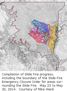 time: Grasshopper Point Picnic Area, Midgley Bridge, Encinoso Picnic Area, Manzanita Campground, and Oak Creek Visitor Center at Indian Gardens. The Oak Creek Canyon Vista Overlook also is open, but is currently only accessible from the north end of Hwy 89A from Flagstaff. Persons wishing to travel from Sedona to Flagstaff are advised to use I-17.
It is important to note that the surrounding forest areas affected by the Slide Fire are currently under a Coconino National Forest Emergency Fire Closure and citizens are prohibited from entering the closure area of National Forest System lands around the Slide Fire. This includes trails and campgrounds north of Slide Rock State Park.
To view the order and map of the fire closure area visit: www.fs.usda.gov/Internet/FSE_DOCUMENTS/stelprd3801868.pdf. For the status of Slide Rock State Park, please visit their website at www.azstateparks.com/Parks/SLRO for updates.
If you are planning to visit a business north of Slide Rock State Park, you may want to call ahead to the business to find out their status. For more information about businesses in the area, you also can visit the Sedona Chamber of Commerce website www.visitsedona.com.
Officials will continue to assess the area for any changes or hazards and work with the residents and business owners to identify needs. Smoke is likely to continue to be an issue. The County Public Health Services District (CCPHSD) advises the public to curtail outdoor activity and to monitor smoke levels.
###
![]() Sedona AZ (May 30, 2014) – AIR QUALITY UPDATE – Downslope winds were strong and persistent overnight Thursday into Friday morning around Sedona, which limited smoke concentrations. These winds moved smoke away from the Flagstaff area into the upper Verde Valley and briefly into Camp Verde. Overall, smoke concentrations for both Flagstaff and Verde Valley were much less on Thursday compared to previous days. This was likely due to high humidity and cooler temperatures resulting in less fire activity and lower smoke production.
Sedona AZ (May 30, 2014) – AIR QUALITY UPDATE – Downslope winds were strong and persistent overnight Thursday into Friday morning around Sedona, which limited smoke concentrations. These winds moved smoke away from the Flagstaff area into the upper Verde Valley and briefly into Camp Verde. Overall, smoke concentrations for both Flagstaff and Verde Valley were much less on Thursday compared to previous days. This was likely due to high humidity and cooler temperatures resulting in less fire activity and lower smoke production.
Decreasing moisture, higher temperatures, and breezy southwesterly winds during the afternoon hours are expected through Sunday. This may result in increased fire activity. If this weather pattern occurs, typical downslope winds during the early morning hours will also likely occur. This means that any smoke produced from the Slide Fire will continue to affect portions of the Verde Valley during the morning before lifting and moving northeasterly towards the Flagstaff area. As fire activity ramps down, heavy impacts may still be possible, but will be dependent on fuel availability and the amount of smoke produced.
For up-to-date monitoring information for particulate matter, visit the Arizona Department of Environmental Quality (ADEQ) Web page for Portable Particulate Monitors, http://www.phoenixvis.net/PPMmain.aspx.
###
![]() Sedona AZ (May 30, 2014) – The Slide Fire is located in Oak Creek Canyon just north of Slide Rock State Park and burned northward, predominantly on the west side of the canyon.
Sedona AZ (May 30, 2014) – The Slide Fire is located in Oak Creek Canyon just north of Slide Rock State Park and burned northward, predominantly on the west side of the canyon.
Yesterday: Crews worked along Highway 89A to chip woody material for removal and patrolled containment lines.
Today: Crews on all areas of the fire perimeter will continue chipping, patrol, and rehabilitation efforts. Internal areas of yet unburned fuel may continue to smolder, producing light to moderate smoke.
Size: 21,217 acres
Containment: 75 percent
Date Reported: Tuesday, May 20 at approximately 4 p.m.
Cause: Human caused, under investigation.
Current Resources: Approximately 511 personnel.
Cost: 8.6 million dollars.

Restrictions & Closures: The Coconino and Kaibab National Forests have implemented Stage II fire restrictions effective Friday (5/30) at 8 a.m., for additional information please visit Arizona Fire Restrictions http://firerestrictions.us/az/
The Coconino National Forest has issued an emergency closure on all National Forest System lands within the area of the Slide Fire on the Coconino National Forest, in Coconino and Yavapai Counties. To view the Order and map of the fire closure area, visit: http://tinyurl.com/mzja5rd
Evacuations UPDATE: The Coconino County Sheriff’s Office, in coordination with area federal and local agencies, lifted the mandatory evacuation order at 1:00 p.m. on Thursday, May 29, for residents evacuated north of Slide Rock State Park. At that time, Hwy 89A reopened to residents and business owners only to allow them to assess their properties. Sheriff’s deputies will continue to operate the roadblock at Slide Rock State Park; residents will be required to present an ID to verify their residency before being allowed to enter.
Access to Hwy 89A north of Slide Rock will be restricted until 6:00 p.m. on Friday to allow residents time to assess their properties and begin cleanup of household debris. The roadway will remain closed at the Pine Flats Campground north to the overlook at the switchbacks.
Smoke will continue to be an immediate issue for many Sedona-area residents. The Coconino County Public Health Services District (CCPHSD) advises the public to curtail outdoor activity and to monitor smoke levels.
For more information, visit www.coconino.az.gov
Closed Roads: Highway 89A from Sedona to Vista Overlook, Forest Road (FR) 535 at Highway 89A, FR 533 at Highway 89A, FR 231 at Rogers Lake, FR 527 and 530 (west side; Volunteer Canyon area) and Casner Mountain is closed to all vehicles. The roadway will remain closed at the Pine Flats campground north to the overlook at the switchbacks for undetermined time.
###
![]() Sedona AZ (May 29, 2014) – AIR QUALITY UPDATE – Strong southerly wind flow overnight Wednesday weakened typical downslope winds, which allowed more smoke to be near the Flagstaff area during the morning hours on Thursday. Heavy smoke impacts were observed in the upper Verde Valley around Sedona before light rainfall and breezy winds in the mid to late morning helped clear the air. The rain and wind also improved the air quality in Flagstaff.
Sedona AZ (May 29, 2014) – AIR QUALITY UPDATE – Strong southerly wind flow overnight Wednesday weakened typical downslope winds, which allowed more smoke to be near the Flagstaff area during the morning hours on Thursday. Heavy smoke impacts were observed in the upper Verde Valley around Sedona before light rainfall and breezy winds in the mid to late morning helped clear the air. The rain and wind also improved the air quality in Flagstaff.
The cooler and moist air mass reduced daytime lift of smoke. Consequently, additional smoke from smoldering and possible unburnt interior fuels is more likely to reduce air quality between Flagstaff and Sedona tonight and Friday morning.
A warmer and drier weather pattern with increasing daytime southwesterly winds will begin Friday afternoon and continue into the weekend, especially on Saturday. Modeled trajectories show Friday afternoon smoke moving north and northeastward. Dispersion and ventilation of daytime smoke will improve, but early morning downslope winds carrying smoke into the upper Verde Valley is expected to continue.
For up-to-date monitoring information for particulate matter, visit the Arizona Department of Environmental Quality (ADEQ) Web page for Portable Particulate Monitors, http://www.phoenixvis.net/PPMmain.aspx.
###
![]() Sedona AZ (May 29, 2014) – The Slide Fire is located in Oak Creek Canyon just north of Slide Rock State Park and burning northward, predominantly on the west side of the canyon.
Sedona AZ (May 29, 2014) – The Slide Fire is located in Oak Creek Canyon just north of Slide Rock State Park and burning northward, predominantly on the west side of the canyon.
Yesterday: Crews continued work along Highway 89A to chip woody material for removal and patrol containment lines. Helicopters conducted water drops on interior ‘island’ pockets of fire activity in extreme rugged terrain. All burnout operations are complete.
 Today: Crews on all areas of the fire perimeter will continue chipping, patrol, and rehabilitation efforts. Internal areas of yet unburned fuel may continue to smolder, producing light to moderate smoke.
Size: 21,067 acres
Containment: 55 percent
Date Reported: Tuesday, May 20 at approximately 4 p.m.
Cause: Human caused, under investigation.
Current Resources: Approximately 676 personnel.
Cost: 8 million dollars.
Restrictions & Closures: Due to increasing fire danger, the Coconino and Kaibab National Forests will implement Stage II fire restrictions effective Friday (5/30) at 8 a.m., for additional information please visit Arizona Fire Restrictions http://firerestrictions.us/az/
The Coconino National Forest has issued an emergency closure on all National Forest System lands within the area of the Slide Fire on the Coconino National Forest, in Coconino and Yavapai Counties. To view the Order and map of the fire closure area, visit:http://tinyurl.com/mzja5rd
Evacuations UPDATE: The Coconino County Sheriff’s Office will reopen US 89A at Slide Rock State Park to residents only at 1 p.m. May 29. Only verified residents will be allowed past the roadblock. For additional information please call the Coconino Information Center (EOC) at (928) 679-4173 between 8:00 a.m. and 5:00 p.m.
Closed Roads: Highway 89A from Sedona to Vista Overlook, Forest Road (FR) 535 at Highway 89A, FR 533 at Highway 89A, FR 231 at Rogers Lake, FR 527 and 530 (west side; Volunteer Canyon area) and Casner Mountain is closed to all vehicles.
Air Quality: For information on air quality, please visit the Arizona Department of Environmental Quality website at: http://www.phoenixvis.net/PPMmain.aspx
###
![]() Sedona AZ (May 28, 2014) – AIR QUALITY UPDATE – Cool temperatures overnight resulted in smoke travelling down into drainages, leading to increased impacts at some of the monitors in the early morning hours on Wednesday. The public continues to be advised that if they feel any health effects from wildfire smoke they should take precautions such as staying indoors and limiting their activity.
Sedona AZ (May 28, 2014) – AIR QUALITY UPDATE – Cool temperatures overnight resulted in smoke travelling down into drainages, leading to increased impacts at some of the monitors in the early morning hours on Wednesday. The public continues to be advised that if they feel any health effects from wildfire smoke they should take precautions such as staying indoors and limiting their activity.
For up-to-date monitoring information for particulate matter, visit the Arizona Department of Environmental Quality (ADEQ) Web page for Portable Particulate Monitors, http://www.phoenixvis.net/PPMmain.aspx. For information regarding the health impacts of wildfire smoke, visit the Arizona Department of Environmental Quality’s (ADEQ) website for Wildfire Support, http://www.azdeq.gov/function/programs/wildfire.html. The Arizona Department of Health Services – Wildfire Smoke & Your Health website, http://www.azdhs.gov/phs/oeh/toxicology/wildfires.htm has information regarding health affects of smoke from wildfires and wildfire safety.
###
![]() Sedona AZ (May 28, 2014) – MORNING UPDATE – The Slide Fire is located in Oak Creek Canyon just north of Slide Rock State Park and burning northward, predominantly on the west side of the canyon.
Sedona AZ (May 28, 2014) – MORNING UPDATE – The Slide Fire is located in Oak Creek Canyon just north of Slide Rock State Park and burning northward, predominantly on the west side of the canyon.
Tuesday crews were able to complete burnout operations for the remaining perimeter. Today crews continue to improve the west and south boundary lines and continue to mop-up and patrol the east and north sides of the fire.
 Weather conditions are expected to be hot and dry with increasing winds today.
Coconino County will hold a community meeting at 6 p.m. today at the Red Rock High School in Sedona to discuss procedures for residents and business owners to re-enter their properties in Oak Creek Canyon.
Size: 20,369 acres (based on infrared photography)
Containment: 45 percent
Injuries: No injuries reported.
Date Reported: Tuesday, May 20 at approximately 4 p.m.
Cause: Human caused, under investigation.
If you have any information that might assist in the investigation of the Slide fire, please contact officials at 928-527-3511.
Structures Threatened: Approximately 300 structures, private homes, vacation resort cabins, and a Forest Service lookout tower. To date no structures have been lost.
Current Resources: Approximately 884 personnel including 22 crews, 29 engines and 9 helicopters.
Closures: The Coconino National Forest has issued an emergency closure on all National Forest System lands within the area of the Slide Fire on the Coconino National Forest, in Coconino and Yavapai Counties. To view the Order and map of the fire closure area, visit:
http://www.fs.usda.gov/detailfull/coconino/landmanagement/ cid=stelprdb5331631&width=full
Closed Roads: Highway 89A from Sedona to Fort Tuthill in Flagstaff, Forest Road (FR) 535 at Highway 89A, FR 533 at Highway 89A, FR 231 at Rogers Lake, FR 527 and 530 (west side; Volunteer Canyon area) and Casner Mountain is closed to all vehicles.
Evacuations: Evacuations remain in place in Oak Creek Canyon from Slide Rock State Park to Sterling Springs Hatchery. Campers who left behind camping gear at Pine Flat and Cave Springs Campground can call the Coconino Information Center (EOC) at (928) 679-4173 between 8:00 a.m. and 5:00 p.m. to arrange to pick up their property.
For information on air quality, please visit the Arizona Department of Environmental Quality website at: http://www.phoenixvis.net/PPMmain.aspx
###
![]() Sedona AZ (May 27, 2014) – EVENING UPDATE – The Slide Fire is located in Oak Creek Canyon just north of Slide Rock State Park.
Sedona AZ (May 27, 2014) – EVENING UPDATE – The Slide Fire is located in Oak Creek Canyon just north of Slide Rock State Park.
Size: 20, 369
Containment: 45%
Today: Work progressed today on the entire perimeter of the fire. On the east flank of the perimeter, crews continued mop up operations, including chipping and rehabilitation work. Handline placed around private property in the southwest area was inspected and is holding in place. The only damage sustained to any private property was one fence post. Some smoke was observed within some interior pockets, but was of no concern.
Tomorrow’s weather is predicted to be very warm and dry. Winds from the south-southwest are expected to increase over the next two days with gusts of 25 mph and with a slight chance of rain going into the weekend. There may be continued burning in interior pockets, but will burn out on its own.
Note: This will be the last evening update.

Location: Originated just about 4 to 5 miles north of Sedona, just north of Slide Rock State Park.
Date Reported: Tuesday, May 20 at approximately 4 p.m.
Cause: Human caused, under investigation.
Law Enforcement is seeking any information the public may have regarding the start of the Slide Fire and anyone of suspicion in the area on the day the fire started between Slide Rock State Park and Half Way Picnic Area. The public should call Forest Service Law Enforcement at 928-527-3511 if they have any information that might assist law enforcement in the investigation.
Structures Threatened: Approximately 300 structures, private homes, vacation resort cabins, and a Forest Service lookout tower. To date no structures have been lost.
Injuries: Injuries were reported on the incident, but none resulted in any lost time.
Current Resources: Approximately 844 personnel.
New closures: The Coconino National Forest has issued an emergency closure on all National Forest System lands within the area of the Slide Fire on the Coconino National Forest, in Coconino and Yavapai Counties. To view the Order and map of the fire closure area, visit:
http://www.fs.usda.gov/detailfull/coconino/landmanagement/ cid=stelprdb5331631&width=full
Closures still in place:
· Highway 89A from Sedona to Fort Tuthill in Flagstaff
· Forest Road (FR) 535 at Highway 89A
· FR 533 at Highway 89A
· FR 231 at Rogers Lake
· FR 527 and 530 (west side; Volunteer Canyon area)
· Casner Mountain is closed to all vehicles
Evacuations: The Coconino County Sheriff’s Office has announced the lifting of the pre-evacuation warning, effective at noon on Monday, May 26 for residents impacted by the Slide Fire in the Kachina Village and Forest Highlands sub-divisions. This action is dependent on fire activity. Evacuations remain in place in Oak Creek Canyon from Slide Rock State Park to Sterling Springs Hatchery. No new evacuations are in place at this time.
Coconino County is reminding people to register their cellphone number with the County’sCodeRED emergency notification system at www.coconino.az.gov/emergency. Only those residents whose numbers are registered will receive a direct phone call about any type of pre- or mandatory evacuation order.
Campers who left behind camping gear at Pine Flat and Cave Springs Campgrounds can call the Information Center 928-679-4173 to arrange pickup of their property.
###
![]() Sedona AZ (May 27, 2014, 5:30pm) – AIR QUALITY UPDATE – Fire activity and prevailing winds is pushing smoke towards the northeast into the Flagstaff area. People are advised that if they feel ill as a result of the smoke they should take precautions such as stay indoors, limit their activities, and contact their health care provider for additional information. For up-to-date monitoring information for particulate matter, visit the Arizona Department of Environmental Quality (ADEQ) Web page for Portable Particulate Monitors, http://www.phoenixvis.net/PPMmain.aspx. For information regarding the health impacts of wildfire smoke, visit the Arizona Department of Environmental Quality’s (ADEQ) website for Wildfire Support, http://www.azdeq.gov/function/programs/wildfire.html. The Arizona Department of Health Services – Wildfire Smoke & Your Health website, http://www.azdhs.gov/phs/oeh/toxicology/wildfires.htm has information regarding health affects of smoke from wildfires and wildfire safety.
Sedona AZ (May 27, 2014, 5:30pm) – AIR QUALITY UPDATE – Fire activity and prevailing winds is pushing smoke towards the northeast into the Flagstaff area. People are advised that if they feel ill as a result of the smoke they should take precautions such as stay indoors, limit their activities, and contact their health care provider for additional information. For up-to-date monitoring information for particulate matter, visit the Arizona Department of Environmental Quality (ADEQ) Web page for Portable Particulate Monitors, http://www.phoenixvis.net/PPMmain.aspx. For information regarding the health impacts of wildfire smoke, visit the Arizona Department of Environmental Quality’s (ADEQ) website for Wildfire Support, http://www.azdeq.gov/function/programs/wildfire.html. The Arizona Department of Health Services – Wildfire Smoke & Your Health website, http://www.azdhs.gov/phs/oeh/toxicology/wildfires.htm has information regarding health affects of smoke from wildfires and wildfire safety.
xxx
![]() Fire update and re-entry plans to be shared at Red Rock High School
Fire update and re-entry plans to be shared at Red Rock High School
Sedona AZ (May 27, 2014) – Coconino County will hold a community meeting at 6 p.m. Wednesday, May 28 at Red Rock High School in Sedona to discuss procedures for residents and business owners to re-enter their properties in Oak Creek Canyon. Red Rock High School is located at 995 Upper Red Rock Loop Road in Sedona.
Several residents and businesses in the Canyon along US 89A, between mile post 381 north to Forest Highlands subdivision, remain under a mandatory-evacuation order since the Slide Fire broke out about 4 p.m. Tuesday, May 20.
During the meeting, residents, business owners and members of the public will be provided an update on the fire. They will also learn of how the County, Sheriff’s Office, APS and other agencies are preparing for when residents are allowed to re-enter their properties.
There is currently no indication when residents or the public will be allowed to re-enter Oak Creek Canyon. US 89A north of Slide Rock State Park and south of Forest Highlands subdivision remains closed.
###
![]() Sedona AZ (May 27, 2004 – AIR QUALITY UPDATE – High levels of particulates have been observed in Sedona and at the portable monitor in Ft. Tuthill early this morning (Tuesday). The public is advised that if they feel ill as a result of wildfire smoke to take necessary precautions including to stay indoors, use a HEPA filter, limit your activities and contact your health care provider for additional information. For up-to-date monitoring information for particulate matter, visit the Arizona Department of Environmental Quality (ADEQ) Web page for Portable Particulate Monitors, http://www.phoenixvis.net/PPMmain.aspx. For information regarding the health impacts of wildfire smoke, visit the Arizona Department of Environmental Quality’s (ADEQ) website for Wildfire Support, http://www.azdeq.gov/function/programs/wildfire.html. The Arizona Department of Health Services – Wildfire Smoke & Your Health website, http://www.azdhs.gov/phs/oeh/toxicology/wildfires.htm has information regarding health affects of smoke from wildfires and wildfire safety.
Sedona AZ (May 27, 2004 – AIR QUALITY UPDATE – High levels of particulates have been observed in Sedona and at the portable monitor in Ft. Tuthill early this morning (Tuesday). The public is advised that if they feel ill as a result of wildfire smoke to take necessary precautions including to stay indoors, use a HEPA filter, limit your activities and contact your health care provider for additional information. For up-to-date monitoring information for particulate matter, visit the Arizona Department of Environmental Quality (ADEQ) Web page for Portable Particulate Monitors, http://www.phoenixvis.net/PPMmain.aspx. For information regarding the health impacts of wildfire smoke, visit the Arizona Department of Environmental Quality’s (ADEQ) website for Wildfire Support, http://www.azdeq.gov/function/programs/wildfire.html. The Arizona Department of Health Services – Wildfire Smoke & Your Health website, http://www.azdhs.gov/phs/oeh/toxicology/wildfires.htm has information regarding health affects of smoke from wildfires and wildfire safety.
###
![]() Sedona AZ (May 27, 2014) – MORNING UPDATE – The Slide Fire is located in Oak Creek Canyon just north of Slide Rock State Park and burning northward, predominantly on the west side of the canyon.
Sedona AZ (May 27, 2014) – MORNING UPDATE – The Slide Fire is located in Oak Creek Canyon just north of Slide Rock State Park and burning northward, predominantly on the west side of the canyon.
Size: 20,328 acres (Acres are based on infrared photography 5/26/14)
Containment: 35 percent
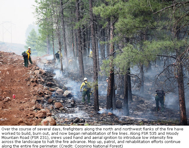
During Memorial Day crews burned out along the Woody Mountain Road, completing the final perimeter burnout around the fire. Over the course of the fire, fire personnel constructed approximately 40 miles of line to form a containment perimeter around the fire. Work was also completed in the removal of hazard trees along Highway 89A. These trees were damaged by the fire and deemed a safety risk to travelers.

 On Tuesday crews will work on holding the containment line along the west edge of the fire and burn out patches of unburned land within the fire line. All firing will be conducted to create low intensity fire on the landscape in a manner where fire managers have more influence on the ultimate outcome. Crews will also be patrolling and mopping up other parts of the fire line to assure the fire stays within containment boundaries. No threats to the fire line are anticipated today.
In addition to holding the fire line within containment boundaries, crews will begin implementing fire rehabilitation guidelines provided by the Coconino National Forest. These guidelines provide direction in mitigating the impact of fire line construction across the fire.
Weather conditions will continue to warm and dry out as the high pressure ridge intensifies into Wednesday. Work was completed on the installation of two Remote Automated Weather Stations (RAWS). The placement locations were designed to provide additional weather date for fire managers to help them understand weather conditions across the fire and the impact those weather conditions will have on burning conditions.
Location: Originated just about 4 to 5 miles north of Sedona, just north of Slide Rock State Park.
Date Reported: Tuesday, May 20 at approximately 4 p.m.
Cause: Human caused, under investigation.
Law Enforcement is seeking any information the public may have regarding the start of the Slide Fire and anyone of suspicion in the area on the day the fire started between Slide Rock State Park and Half Way Picnic Area. The public should call Forest Service Law Enforcement at 928-527-3511 if they have any information that might assist law enforcement in the investigation.
Structures Threatened: Approximately 300 structures, private homes, vacation resort cabins, and a Forest Service lookout tower. To date no structures have been lost.
Injuries: No injuries reported.
Current Resources:Approximately 1081 personnel including 28 crews, 58 engines, 9 helicopters, 2 air attack planes, and other resources which are not assigned but available to the incident such as heavy air tankers.
Closures: The Coconino National Forest has issued an emergency closure on all National Forest System lands within the area of the Slide Fire on the Coconino National Forest, in Coconino and Yavapai Counties. To view the Order and map of the fire closure area, visit:
http://www.fs.usda.gov/detailfull/coconino/landmanagement/?cid=stelprdb5331631&width=full
- Highway 89A from Sedona to Fort Tuthill in Flagstaff
- Forest Road (FR) 535 at Highway 89A
- FR 533 at Highway 89A
- FR 231 at Rogers Lake
- FR 527 and 530 (west side; Volunteer Canyon area)
- Casner Mountain is closed to all vehicles
Evacuations: Evacuations remain in place in Oak Creek Canyon from Slide Rock State Park to Sterling Springs Hatchery. Campers who left behind camping gear at Pine Flat and Cave Springs Campground can call the Coconino Information Center (EOC) at (928) 679-4173 between 8:00 a.m. and 5:00 p.m. to arrange to pick up their property.
Coconino County is reminding people to register their cellphone number with the County’s CodeRED emergency notification system at www.coconino.az.gov/emergency. Only those residents whose numbers are registered will receive a direct phone call about any type of pre- or mandatory evacuation order.
For information on air quality, please visit the Arizona Department of Environmental Quality website at: http://www.phoenixvis.net/PPMmain.aspx
###
![]() Sedona AZ (May 26, 2014) – EVENING UPDATE – The Slide Fire is located in Oak Creek Canyon just north of Slide Rock State Park and burning northward, predominantly on the west side of the canyon.
Sedona AZ (May 26, 2014) – EVENING UPDATE – The Slide Fire is located in Oak Creek Canyon just north of Slide Rock State Park and burning northward, predominantly on the west side of the canyon.
Size: 18,500
Containment: 35%
Today: Fire personnel continued to work on rehabilitating fire line from Slide Rock State Park north to the 89A switchbacks and west along the north and northwest flanks Crews used hand ignition to promote a low intensity burn due to the higher temperatures and lower humidity. Arizona Public Service personnel removed hazard trees throughout Oak Creek Canyon.
Tonight: Burnout operations will continue overnight along Woody Mountain Road (FSR 231) near West Buzzard Point to complete the containment buffer. Line preparation for burnout operations will continue on the western flank. Smoke is anticipated to settle over the larger fire area this evening. Motorists please be aware of diminished visibility and wildlife. For information on air quality, please visit the Arizona Department of Environmental Quality website at: http://www.phoenixvis.net/PPMmain.aspx
Location: Originated just about 4 to 5 miles north of Sedona, just north of Slide Rock State Park.
Date Reported: Tuesday, May 20 at approximately 4 p.m.
Cause: Human caused, under investigation.
Law Enforcement is seeking any information the public may have regarding the start of the Slide Fire and anyone of suspicion in the area on the day the fire started between Slide Rock State Park and Half Way Picnic Area. The public should call Forest Service Law Enforcement at 928-527-3511 if they have any information that might assist law enforcement in the investigation.
Structures Threatened: Approximately 300 structures, private homes, vacation resort cabins, and a Forest Service lookout tower. To date no structures have been lost.
Injuries: No significant injuries reported.
Current Resources: Approximately 1,092 personnel
Closures:
NEW: The Coconino National Forest has issued an emergency closure on all National Forest System lands within the area of the Slide Fire on the Coconino National Forest, in Coconino and Yavapai Counties. To view the Order and map of the fire closure area, visit:
http://www.fs.usda.gov/detailfull/coconino/landmanagement/ cid=stelprdb5331631&width=full
Previous closures still in place:
- Highway 89A from Sedona to Fort Tuthill in Flagstaff
- Forest Road (FR) 535 at Highway 89A
- FR 533 at Highway 89A
- FR 231 at Rogers Lake
- FR 527 and 530 (west side; Volunteer Canyon area)
- Casner Mountain is closed to all vehicles
Evacuations: The Coconino County Sheriff’s Office has announced the lifting of the pre-evacuation warning, effective at noon on Monday, May 26 for residents impacted by the Slide Fire in the Kachina Village and Forest Highlands sub-divisions. This action is dependent on fire activity. Evacuations remain in place in Oak Creek Canyon from Slide Rock State Park to Sterling Springs Hatchery. No new evacuations are in place at this time.
Coconino County is reminding people to register their cellphone number with the County’s CodeRED emergency notification system at www.coconino.az.gov/emergency. Only those residents whose numbers are registered will receive a direct phone call about any type of pre- or mandatory evacuation order.
Campers who left behind camping gear at Pine Flat and Cave Springs Campgrounds can call the Information Center 928-679-4173 to arrange pickup of their property.
###
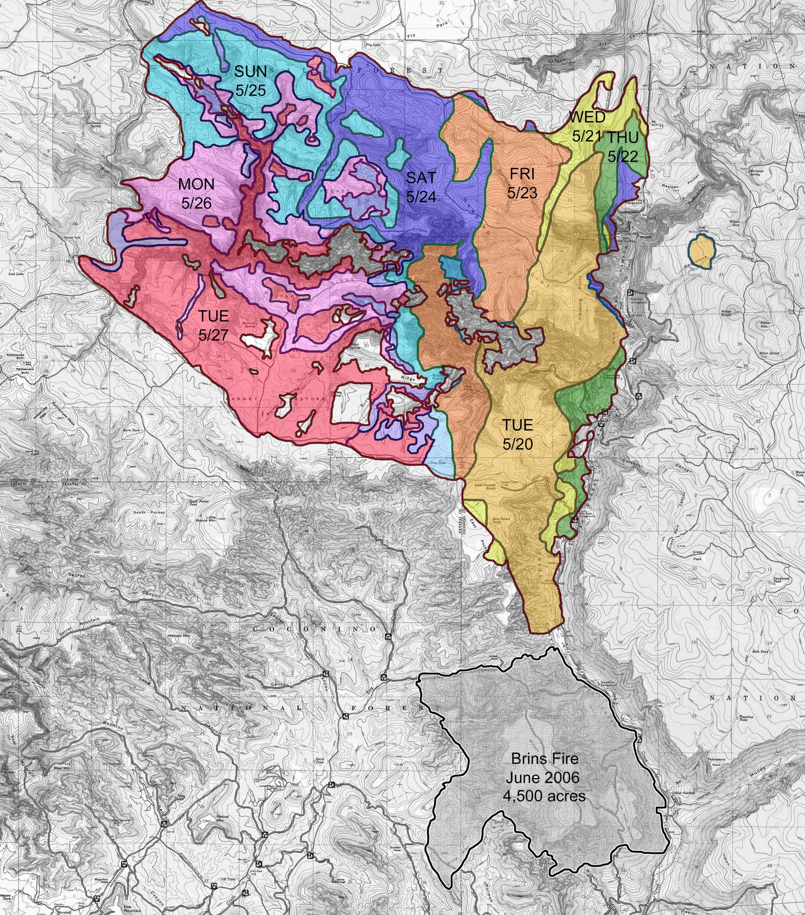
 Sedona AZ (May 26, 2014) – Sedona Resident and City Councilor Mike Ward has provided a detailed map tracking the Slide Fire progress and is generously allowing us to share with
Sedona.biz readers. The map is quite large allowing for excellent detail when zoomed in. Thank you Mr. Ward!
###
![]() Sedona AZ (May 26, 2014) – AIR QUALITY UPDATE – The monitored levels of particulates on the Sedona area were lower in the late evening hours into early Monday morning but still remain elevated. Breezy westerly and northwesterly winds that are forecasted into Monday may override the normal upslope – downslope wind pattern pushing smoke east of the fire. Areas east of I-17 may experience intermittent impacts throughout the day with chances of moderate impacts to the areas of Village of Oak Creek, Rim Rock, Camp Verde and the lower Verde Valley overnight and into the early morning hours. Impacts north of the San Francisco Peaks should be minimal.
Sedona AZ (May 26, 2014) – AIR QUALITY UPDATE – The monitored levels of particulates on the Sedona area were lower in the late evening hours into early Monday morning but still remain elevated. Breezy westerly and northwesterly winds that are forecasted into Monday may override the normal upslope – downslope wind pattern pushing smoke east of the fire. Areas east of I-17 may experience intermittent impacts throughout the day with chances of moderate impacts to the areas of Village of Oak Creek, Rim Rock, Camp Verde and the lower Verde Valley overnight and into the early morning hours. Impacts north of the San Francisco Peaks should be minimal.
For up-to-date monitoring information for particulate matter, visit the Arizona Department of Environmental Quality (ADEQ) Web page for Portable Particulate Monitors, http://www.phoenixvis.net/PPMmain.aspx.
The public is advised that if they feel ill as a result of wildfire smoke to take necessary precautions including to stay indoors, use a HEPA filter, limit your activities and contact your health care provider for additional information. Residents and motorists are asked to use caution as visibility may be limited at times. For information regarding the health impacts of wildfire smoke, visit the Arizona Department of Environmental Quality’s (ADEQ) website for Wildfire Support, http://www.azdeq.gov/function/programs/wildfire.html. The Arizona Department of Health Services – Wildfire Smoke & Your Health website, http://www.azdhs.gov/phs/oeh/toxicology/wildfires.htm has information regarding health affects of smoke from wildfires and wildfire safety.

###
![]() Sedona AZ (May 26, 2014) – MORNING UPDATE – The Slide Fire is located in Oak Creek Canyon just north of Slide Rock State Park and burning northward, predominantly on the west side of the canyon.
Sedona AZ (May 26, 2014) – MORNING UPDATE – The Slide Fire is located in Oak Creek Canyon just north of Slide Rock State Park and burning northward, predominantly on the west side of the canyon.
Size: 16,365 acres (Acres are based on infrared photography 5/25/14)
Containment: 25 percent
On Sunday, significant progress was made in completing the burnout operation between the West Fork of Oak Creek Canyon and the northern boundary of the fire along Forest Road 535. Crews assisted by helicopters dropping ignition devices (PSD) burned out the remaining parts of this area which will help prevent the further movement of the fire to the north. During the evening crews continued to burn out lines along the Woody Mountain Road (FR231) on the southwest side of the fire.
 On Memorial Day crews will continue burnout operations between FR 231 and the south side of the West Fork of Oak Creek Canyon. Crews will begin rehabilitation work along Highway 89 and the developed areas on the southeast corner of the fire in Oak Creek Canyon. Vegetative debris created earlier during firefighting efforts will be chipped and hauled from the area.
The weather over the next three days will change significantly as the low pressure over the fire during the weekend moves east and is replaced by high pressure bringing warmer and dryer air. Temperatures are anticipated to rise 5 to 8 degrees a day to mid-week with an accompanying drop in humidity. To allow fire managers to better assess weather conditions over the fire, two Remote Automated Weather Stations (RAWS) will be installed within and near the fire area to measure local weather conditions.
Considering the steep rugged terrain associated with this fire, the incident has had an excellent safety record. Although there have been some minor injuries, all firefighters returned to work. Medical issues have included treatment for poison oak and ivy exposure.
Location: Originated just about 4 to 5 miles north of Sedona, just north of Slide Rock State Park.
Date Reported: Tuesday, May 20 at approximately 4 p.m.
Cause: Human caused, under investigation.
Law Enforcement is seeking any information the public may have regarding the start of the Slide Fire and anyone of suspicion in the area on the day the fire started between Slide Rock State Park and Half Way Picnic Area. The public should call Forest Service Law Enforcement at 928-527-3511 if they have any information that might assist law enforcement in the investigation.
Structures Threatened: Approximately 300 structures, private homes, vacation resort cabins, and a Forest Service lookout tower. To date no structures have been lost.
Injuries: No injuries reported.
Current Resources:Approximately 1,236 personnel including 35 crews, 61 engines, 9 helicopters, 2 air attack planes, and other resources which are not assigned but available to the incident such as heavy air tankers.
Closures:
NEW: The Coconino National Forest has issued an emergency closure on all National Forest System lands within the area of the Slide Fire on the Coconino National Forest, in Coconino and Yavapai Counties. To view the Order and map of the fire closure area, visit:
http://www.fs.usda.gov/detailfull/coconino/landmanagement/?cid=stelprdb5331631&width=full
- Highway 89A from Sedona to Fort Tuthill in Flagstaff
- Forest Road (FR) 535 at Highway 89A
- FR 533 at Highway 89A
- FR 231 at Rogers Lake
- FR 527 and 530 (west side; Volunteer Canyon area)
- Casner Mountain is closed to all vehicles
Evacuations: The Coconino County Sheriff’s Office has announced the lifting of the pre-evacuation warning, effective at noon on Monday, May 26 for residents impacted by the Slide Fire in the Kachina Village and Forest Highlands sub-divisions. This action is dependent on fire activity. Evacuations remain in place in Oak Creek Canyon from Slide Rock State Park to Sterling Springs Hatchery. No new evacuations are in place at this time.
Coconino County is reminding people to register their cellphone number with the County’s CodeRED emergency notification system at www.coconino.az.gov/emergency. Only those residents whose numbers are registered will receive a direct phone call about any type of pre- or mandatory evacuation order.
For information on air quality, please visit the Arizona Department of Environmental Quality website at:
###
![]() Sedona AZ (May 25, 2014) – EVENING UPDATE – The Slide Fire is located in Oak Creek Canyon just north of Slide Rock State Park and burning northward, predominantly on the west side of the canyon.
Sedona AZ (May 25, 2014) – EVENING UPDATE – The Slide Fire is located in Oak Creek Canyon just north of Slide Rock State Park and burning northward, predominantly on the west side of the canyon.
Size: 14,100
Containment: 25%
The Incident Management Team thanks the Sedona Fire Department for having a structure preparation plan in place for Oak Creek Canyon. This plan assisted team members in quickly dispatching resources to appropriate areas. This smooth transition was elemental in protecting structures within the canyon.
Today:
Fire personnel worked on rehabilitating fire line near Slide Rock State Park, and monitoring fire activity surrounding the fish hatchery and switchbacks. Along FSR 535 crews continued patrols and began mop up. Crews continued burnout operations today moving south along Woody Mountain Road (FSR 231). To promote a low intensity burn, surface fire was applied via aerial ignition near the tops of West Fork Canyon and Casner Cabin Draw. This practice allows fire to slowly back down into the canyon bottom lessening impacts to watersheds. Crews will continue to mop up and reinforce completed containment lines on the perimeter of the fire.
Tonight:
 Burnout operations will continue throughout the night along Woody Mountain Road creating a buffer area for the approaching main fire. Line preparation for burnout operations will continue moving south and southeast in front of the burnout operations. Fire managers are anticipating burnout operations will conclude by Tuesday. Smoke is anticipated to settle over the larger fire area this evening. Motorists please be aware of diminished visibility and wildlife. For information on air quality, please visit the Arizona Department of Environmental Quality website at: http://www.phoenixvis.net/PPMmain.aspx
The Incident Management Team expresses their sincere thanks for donations which were received in support of our firefighters. However they request that future donations be made to charities like the Salvation Army, United Way, the American Red Cross, Coconino and Yavapai Search and Rescue, or other local charitable organizations. Firefighters working the Slide Fire are well supplied and need no further clothing and food items. Individuals wanting to donate their time should contact the Northern Arizona United Way at (928) 773-9813 or nazunitedway.org. Monetary contributions can be made to the Wildland Firefighter Foundation at http://www.wffoundation.org/.
Location: Originated just about 4 to 5 miles north of Sedona, just north of Slide Rock State Park.
Date Reported: Tuesday, May 20 at approximately 4 p.m.
Cause: Human caused, under investigation.
Law Enforcement is seeking any information the public may have regarding the start of the Slide Fire and anyone of suspicion in the area on the day the fire started between Slide Rock State Park and Half Way Picnic Area. The public should call Forest Service Law Enforcement at 928-527-3511 if they have any information that might assist law enforcement in the investigation.
Structures Threatened: Approximately 300 structures, private homes, vacation resort cabins, and a Forest Service lookout tower. To date no structures have been lost.
Injuries: No significant injuries reported.
Current Resources: Approximately 1,236 personnel including 35 crews, 61 engines, nine helicopters, two air attack planes, and other resources which are not assigned but available to the incident such as heavy air tankers.
Closures:
NEW: The Coconino National Forest has issued an emergency closure on all National Forest System lands within the area of the Slide Fire on the Coconino National Forest, in Coconino and Yavapai Counties. To view the Order and map of the fire closure area, visit:
http://www.fs.usda.gov/detailfull/coconino/landmanagement/?cid=stelprdb5331631&width=full
Previous closures still in place:
- Highway 89A from Sedona to Fort Tuthill in Flagstaff
- Forest Road (FR) 535 at Highway 89A
- FR 533 at Highway 89A
- FR 231 at Rogers Lake
- FR 527 and 530 (west side; Volunteer Canyon area)
- Casner Mountain is closed to all vehicles
Evacuations: The Coconino County Sheriff’s Office has announced the lifting of the pre-evacuation warning, effective at noon on Monday, May 26 for residents impacted by the Slide Fire in the Kachina Village and Forest Highlands sub-divisions. This action is dependent on fire activity. Evacuations remain in place in Oak Creek Canyon from Slide Rock State Park to Sterling Springs Hatchery. No new evacuations are in place at this time.
Coconino County is reminding people to register their cellphone number with the County’s CodeRED emergency notification system at www.coconino.az.gov/emergency. Only those residents whose numbers are registered will receive a direct phone call about any type of pre- or mandatory evacuation order.
###
![]() Sedona AZ (May 25, 2014) – ADEQ Air Quality Outlook Report – Lighter winds and cooler high temperatures kept the smoke near the fire Friday. As a result, the Flagstaff and Verde Valley monitors observed longer duration of smoke impacts. The Ft. Tuthill monitor increased from the Good AQI category to Moderate. Sedona also saw a longer duration of smoke but the impacts were lessened by the south-southeasterly flow Friday evening.
Sedona AZ (May 25, 2014) – ADEQ Air Quality Outlook Report – Lighter winds and cooler high temperatures kept the smoke near the fire Friday. As a result, the Flagstaff and Verde Valley monitors observed longer duration of smoke impacts. The Ft. Tuthill monitor increased from the Good AQI category to Moderate. Sedona also saw a longer duration of smoke but the impacts were lessened by the south-southeasterly flow Friday evening.
Breezy westerly and northwesterly winds that are forecasted for Sunday into Monday may override the normal upslope – downslope wind pattern pushing smoke east of the fire. Areas east of I17 may experience intermittent impacts throughout the day with chances of moderate impacts to the areas of Village of Oak Creek, Rim Rock, Camp Verde and the lower Verde Valley overnight and into the early morning hours. Impacts north of the San Francisco Peaks should be minimal.
Outflow winds caused by thunderstorm activity in the region may cause smoke impacts to areas previously unaffected.
###
![]() Sedona AZ (May 25, 2014) – 7am UPDATE – The Slide Fire is located in Oak Creek Canyon just north of Slide Rock State Park and burning northward, predominantly on the west side of the canyon.
Sedona AZ (May 25, 2014) – 7am UPDATE – The Slide Fire is located in Oak Creek Canyon just north of Slide Rock State Park and burning northward, predominantly on the west side of the canyon.
Size: 13,423 acres (Acres are based on infrared photography 5/24/14)
On Saturday, efforts to suppress the fire were hindered by smoke which prohibited the use of aerial observation aircraft. Helicopter activity supporting firefighters on the line was also significantly reduced. Late in the day a helicopter was able to complete a mission dropping ignition devices (PSD) to burnout fuels between the West Fork of Oak Creek Canyon and the fire line along Forest Road 535.  High moisture levels over the fire during the night time hours prohibited further burnout operations. Yesterday a 230KW power transmission line was re-energized northwest of the fire. Another APS line was also energized heading east from the Arizona Department of Transportation maintenance facility near the Overlook on Highway 89.
On Friday Congresswoman Ann Kirkpatrick and Arizona Representative Bob Thorpe visited the Incident Command Post. They were briefed by members of the Incident Command Team on fire strategy, potential fire impacts, and evacuations in the fire area.
Burnout operations will continue today along Woody Mountain Road FR231 depending on weather conditions and the outcome of nightshift operations. Crews will continue to mop up and reinforce completed containment lines on the perimeter of the fire. Fire personnel will also be working with APS in Oak Creek Canyon to repair power lines damaged in the area. Although burning conditions today will be tempered by weather conditions, a warmer and dryer period is expected for early this week.
Although numerous burnout operations have occurred over the fire, the overall impact is very similar to those of a controlled burn. Sensitive application of fire is utilized to minimize impact on the forest.
The Incident Management Team expresses their sincere thanks for donations which were received in support of our firefighters. However they request that future donations be made to charities like the Salvation Army, United Way, the American Red Cross, Coconino and Yavapai Search and Rescue, or other local charitable organizations. Firefighters working the Slide Fire are well supplied and need no further clothing and food items. Individuals wanting to donate their time should contact the Northern Arizona United Way at (928) 773-9813 or nazunitedway.org.
Location: Originated just about 4 to 5 miles north of Sedona, just north of Slide Rock State Park.
Date Reported: Tuesday, May 20 at approximately 4 p.m.
Cause: Human caused, under investigation.
Law Enforcement is seeking any information the public may have regarding the start of the Slide Fire and anyone of suspicion in the area on the day the fire started between Slide Rock State Park and Half Way Picnic Area. The public should call Forest Service Law Enforcement at 928-527-3511 if they have any information that might assist law enforcement in the investigation.
Containment: 10%
Structures Threatened: Approximately 300 structures, private homes, vacation resort cabins, and a Forest Service lookout tower. To date no structures have been lost.
Injuries: No injuries reported.
Current Resources: Approximately 1,219 personnel including 38 crews, 62 engines, nine helicopters, two air attack planes, and other resources which are not assigned but available to the incident such as heavy air tankers.
Closures:
- Highway 89A from Sedona to Fort Tuthill in Flagstaff
- Forest Road (FR) 535 at Highway 89A
- FR 533 at Highway 89A
- FR 231 at Rogers Lake
- FR 527 and 530 (west side; Volunteer Canyon area)
- Casner Mountain is closed to all vehicles
Evacuations: The Coconino County Sheriff’s Office has announced the lifting of the pre-evacuation warning, effective at noon on Monday, May 26 for residents impacted by the Slide Fire in the Kachina Village and Forest Highlands sub-divisions. This action is dependent on fire activity. Evacuations remain in place in Oak Creek Canyon from Slide Rock State Park to Sterling Springs Hatchery. No new evacuations are in place at this time.
Coconino County is reminding people to register their cellphone number with the County’s CodeRED emergency notification system at www.coconino.az.gov/emergency. Only those residents whose numbers are registered will receive a direct phone call about any type of pre- or mandatory evacuation order.
For information on air quality, please visit the Arizona Department of Environmental Quality website at: http://www.phoenix.net/PPMmain.aspx
###
![]() Sedona AZ (May 24, 2014) – EVENING UPDATE – The Slide Fire is located in Oak Creek Canyon just north of Slide Rock State Park and burning northward, predominantly on the west side of the canyon.
Sedona AZ (May 24, 2014) – EVENING UPDATE – The Slide Fire is located in Oak Creek Canyon just north of Slide Rock State Park and burning northward, predominantly on the west side of the canyon.
Today:
Fire behavior has been suppressed today by smoke and cloud cover. Weather conditions over the Slide Fire created a smoke inversion over the fire and surrounding areas throughout most of the day. This caused incident aircraft to be grounded and the use of helicopters for aerial ignition could not occur until late in the afternoon. Line crews continued to burnout the area between the West Fork of Oak Creek Canyon, Forest Road (FR) 535 and Woody Mountain Road (FR 231). Fire is slowly moving up the West Fork of Oak Creek Canyon and onto the top of Buzzard Ridge and Barney Pasture. Mop up continued around structures in Oak Creek Canyon.
 The Coconino County Sheriff’s Office announced the lifting of the pre-evacuation warning, effective at noon on Monday, May 26 for residents impacted by the Slide Fire in the Kachina Village and Forest Highlands sub-divisions. This action is dependent on fire activity. Evacuations remain in place in Oak Creek Canyon from Slide Rock State Park to Sterling Springs Hatchery. No new evacuations are in place at this time.
Tonight:
Burnout operations will continue throughout the night along Woody Mountain Road creating a buffer area for the approaching main fire. Much of the burnout operations are being conducted at night, to take advantage of low humidity and temperature, which will keep fire intensity low. This is important because it helps minimize impacts to the watershed. Fire managers are anticipating burnout operations will conclude by Tuesday.
Because of fire conditions Coconino County has instituted a ban on open burning on County public lands and private lands in the unincorporated areas of the County. The ban went into effect at 10:30 a.m. Friday May 23 and will remain in effect until fire danger conditions subside. Further information on this ban may be found at www.coconino.az.gov.
The Incident Management Team expresses their sincere thanks for donations which were received in support of our firefighters. However they request that future donations be made to charities like United Way, the American Red Cross, Coconino and Yavapai Search and Rescue, or other local charitable organizations. Firefighters working the Slide Fire are well supplied and need no further clothing and food items. Individuals wanting to donate their time should contact the Northern Arizona United Way at (928) 773-9813 or nazunitedway.org.
Size: Approximately 11,800 acres.
Containment: 5%
Location: Originated just about 4 to 5 miles north of Sedona, just north of Slide Rock State Park.
Date Reported: Tuesday, May 20 at approximately 4 p.m.
Cause: Human caused, under investigation.
Law Enforcement is seeking any information the public may have regarding the start of the Slide Fire and anyone of suspicion in the area on the day the fire started between Slide Rock State Park and Half Way Picnic Area. The public should call Forest Service Law Enforcement at 928-527-3511 if they have any information that might assist law enforcement in the investigation.
Structures Threatened: Approximately 300 structures, private homes as well vacation resort cabins and a Forest Service lookout tower.
Injuries: No significant injuries reported.
Current Resources: Approximately 975 personnel including 36 crews, 46 engines, nine helicopters, two air attack, and other resources.
Closures:
- Highway 89A from Sedona to Fort Tuthill in Flagstaff
- Forest Road (FR) 535 at Highway 89A
- FR 533 at Highway 89A
- FR 231 at Rogers Lake
- FR 527 and 530 (west side; Volunteer Canyon area)
- Casner Mountain is closed to all vehicles
Coconino County is reminding people to register their cellphone number with the County’s CodeRED emergency notification system at www.coconino.az.gov/emergency. Only those residents whose numbers are registered will receive a direct phone call about any type of pre- or mandatory evacuation order.
For information on air quality, please visit the Arizona Department of Environmental Quality website at http://www.phoenixvis.net/PPMmain.aspx
###
![]() Sedona AZ (May 24, 2014) – MIDDAY UPDATE – The Slide Fire is located in Oak Creek Canyon just north of Slide Rock State Park and burning northward, predominantly on the west side of the canyon.
Sedona AZ (May 24, 2014) – MIDDAY UPDATE – The Slide Fire is located in Oak Creek Canyon just north of Slide Rock State Park and burning northward, predominantly on the west side of the canyon.
Size: Approximately 10,609 acres.
The weather conditions in the area of the Slide Fire remained fairly stagnant this morning. The failure of the air inversion to lift has grounded observation aircraft and prohibited the use of helicopters for aerial ignition. Line crews will continue to burnout by hand the area between the West Fork of Oak Creek Canyon and Forest Road 535. Mop up is continuing around structures in Oak Creek Canyon.
 Because of fire conditions Coconino County has instituted a ban on open burning on County public lands and private lands in the unincorporated areas of the County. The ban went into effect at 10:30 a.m. Friday May 23 and will remain in effect until fire danger conditions subside. Further information on this ban may be found at www.coconino.az.gov.
The Incident Management Team expresses their sincere thanks for donations which were received in support of our firefighters. However they request that future donations be made to charities like United Way, the American Red Cross, Coconino and Yavapai Search and Rescue, or other local charitable organizations. Firefighters working the Slide Fire are well supplied and need no further clothing and food items. Individuals wanting to donate their time should contact the Northern Airzona United Way at (928) 773-9813 or nazunitedway.org.
Coconino County is reminding people to register their cellphone number with the County’s CodeRED emergency notification system at www.coconino.az.gov/emergency. Only those residents whose numbers are registered will receive a direct phone call about any type of pre- or mandatory evacuation order.
For information on air quality, please visit the Arizona Department of Environmental Quality website at http://wildlandfire.az.gov
###
![]() Sedona AZ (May 24, 2014) – Sedona Fire District has provided an informational flyer containing website links that provide direct access to information that may be interesting to Sedona and Verde Valley residents. These websites include the Slide Fire, road closures, air quality, donation, Code Red sign up and other information. https://sedona.biz//wp-content/uploads/2014/05/20140524_SFD-Slide-Fire-Flyer-Master-2014.pdf
Sedona AZ (May 24, 2014) – Sedona Fire District has provided an informational flyer containing website links that provide direct access to information that may be interesting to Sedona and Verde Valley residents. These websites include the Slide Fire, road closures, air quality, donation, Code Red sign up and other information. https://sedona.biz//wp-content/uploads/2014/05/20140524_SFD-Slide-Fire-Flyer-Master-2014.pdf
###
![]() Sedona AZ (May 24, 2014) – 9:00AM UPDATE – The Slide Fire is located in Oak Creek Canyon just north of Slide Rock State Park and burning northward, predominantly on the west side of the canyon.
Sedona AZ (May 24, 2014) – 9:00AM UPDATE – The Slide Fire is located in Oak Creek Canyon just north of Slide Rock State Park and burning northward, predominantly on the west side of the canyon.
Size: Approximately 10,609 acres.
Last night crews performed firing operations along the north side of the fire to remove fuel along a power line which supplies electricity to Flagstaff. Night time firing operations were especially effective because lower temperatures, higher humidity, and calmer wind moderated fire behavior.
 Much of the terrain in the canyon is steep and rugged, making conditions unsafe for firefighters. An outstanding example of the good work being done by firefighters was the treatment applied to the switchbacks on Highway 89A Thursday night and Friday. Hotshot crews built a containment line across the switchbacks, and brought fire downhill, burning out the west side of Oak Creek Canyon to the bottom. This low intensity backing fire removed fine fuels and ladder fuels, preventing fire from running upslope, and consuming forest vegetation in its path.
Today, firefighters are preparing line on the southwest side in anticipation of additional burnout operations. Along the northern perimeter crews will patrol and continue mop up of last night’s firing operations, while preparing for more burn out operations tonight. Chipping crews will chip brush and slash along the east side of the fire. Along the eastern flank, mop up of last night’s firing operations, monitoring, and structure protection will be the priorities for the day. Aircraft will support ground forces with water drops, and with PSD (perforated spherical device) firing operations.
Structure protection will continue in the Kachina Village and Forest Highlands areas.
Containment: 5%
Location: Originated just about 4 to 5 miles north of Sedona, just north of Slide Rock State Park.
Date Reported: Tuesday, May 20 at approximately 4 p.m.
Cause: Human caused, under investigation
Structures Threatened: Approximately 300 structures, private homes, vacation resort cabins, and a Forest Service lookout tower. To date no structures have been lost.
Injuries: No injuries reported.
Current Resources: Approximately 975 personnel including 36 crews, 46 engines, three air tankers, nine helicopters, two air attack planes, and other resources.
Closures:
- Highway 89A from Sedona to Fort Tuthill in Flagstaff
- Forest Road (FR) 535 at Highway 89A
- FR 533 at Highway 89A
- FR 231 at Rogers Lake
- FR 527 and 530 (west side; Volunteer Canyon area)
- Casner Mountain is closed to all vehicles
Evacuations: Evacuations remain in place in Oak Creek Canyon from Slide Rock State Park to Sterling Springs Hatchery. Coconino County issued a pre-evacuation notice to residents of Kachina Village and Forest Highlands subdivisions. Residents are advised to be prepared to evacuate. County Emergency Management encourages those in the affected neighborhoods to begin packing important items they may need for several days. These items include prescriptions, important papers, any special dietary needs and pets. No new evacuations are in place at this time.
Coconino County is reminding people to register their cellphone number with the County’s CodeRED emergency notification system at www.coconino.az.gov/emergency. Only those residents whose numbers are registered will receive a direct phone call about any type of pre- or mandatory evacuation order.
For information on air quality, please visit the Arizona Department of Environmental Quality website at: http://wildlandfire.az.gov
###
![]() Sedona AZ (May 23, 2014) – 8:15 UPDATE – FIRE ACTIVITY: Work continues along FSR 231 and FSR 535 to prepare for burnout operations. Firefighters are utilizing aerial ignitions by helicopter and continuing ground burnout operations on the north and west flanks. Aerial ignitions are applied to the top of slopes; it creates a low intensity fire that backs slowly down the canyon to prevent fire from gaining momentum upslope. Crews continue to protect structures in Oak Creek Canyon.
Sedona AZ (May 23, 2014) – 8:15 UPDATE – FIRE ACTIVITY: Work continues along FSR 231 and FSR 535 to prepare for burnout operations. Firefighters are utilizing aerial ignitions by helicopter and continuing ground burnout operations on the north and west flanks. Aerial ignitions are applied to the top of slopes; it creates a low intensity fire that backs slowly down the canyon to prevent fire from gaining momentum upslope. Crews continue to protect structures in Oak Creek Canyon.
Over a hundred spot fires were found last night with an infrared flight north of the fire. Crews were able to line and mop-up the spots easily due to past fuel treatments in the area.
Firefighter safety is our number one priority. Due to the extreme terrain, our suppression strategy is to create containment lines in safer areas far ahead of the fire, reinforcing these lines with low-intensity burnout operations. This means fire managers are expecting the size of the fire’s footprint to greatly increase, but many areas will receive much lighter fire behavior.
SIZE: Approximately 7,500 acres; 5% containment
AIR QUALITY: A low-pressure system moving into the area on Thursday helped push the smoke north and northwest of the fire. Additionally, increased moisture and cloud cover lowered afternoon temperatures resulting in less lift of daytime smoke. This contributed to slightly elevated smoke impacts in the Flagstaff area during the evening before smoke drained towards the Verde Valley overnight. Sedona still experienced Unhealthy air quality during the early Friday morning; with surrounding areas observing minimal smoke impacts. Lighter winds this weekend and cooler high temperatures will help keep more smoke near the fire. As a result, the Flagstaff area and Verde Valley may observe increased and longer duration smoke impacts. Potential thunderstorm activity has been forecasted for the area. Outflow winds from thunderstorms are capable of causing smoke impacts into areas previously unaffected. For up-to-date monitoring information for particulate matter, visit ADEQ’s Web page for Portable Particulate Monitors, http://www.phoenixvis.net/PPMmain.aspx.
Visit the Arizona Department of Environmental Quality’s (ADEQ) website for Wildfire Support, http://www.azdeq.gov/function/programs/wildfire.html. The Arizona Department of Health Services – Wildfire Smoke & Your Health website, http://www.azdhs.gov/phs/oeh/toxicology/wildfires.htm has information regarding health affects of smoke from wildfires and wildfire safety.
Residents and motorists are asked to use caution as visibility may be limited at times. The Coconino County Public Health Services District is advising the public that if they feel ill as a result of wildfire smoke to take necessary precautions including to stay indoors, use a HEPA filter, limit your activities and contact your health care provider for additional information. Smoke will likely continue to drift north and be noticeable along I-17 approaching northern Arizona.
EVACUATIONS: As of Friday evening there are no new evacuations. Evacuations remain in place in Oak Creek Canyon from Slide Rock State Park to Sterling Springs Hatchery. There is a pre-evacuation notice for residents in Kachina Village & Forest Highlands subdivisions, these areas are not under a mandatory evacuation at this time. Residents are advised to be prepared to evacuate. Residents will be given advanced warning if further action is required. If a mandatory evacuation is ordered, residents will be notified through Coconino County’s CodeRed emergency notification system and Coconino County Sheriff uniformed deputies will go door-to-door to evacuate residents. Coconino County is reminding people to register their cell phone number with the CodeRed system at www.coconino.az.gov/emergency. Only registered phone numbers will receive notifications about any pre- or mandatory evacuation order. Coconino County Emergency Management encourages those in affected neighborhoods to begin packing important items they might need for several days such as prescriptions, important papers, specific dietary needs and pets. Officials have set up an evacuation center located at Sinagua Middle School at 3950 E Butler Ave. in Flagstaff. A shelter for pets has been set up at the Coconino Humane Association 3501 E. Butler Ave.
CLOSURES: Hwy 89A from Sedona to Ft. Tuthill, Forest Road (FR) 535 at Hwy 89A, FR 533 at Hwy 89A, FR 231 at Rogers Lake, FR 527 & 530 (west side, Volunteer Canyon area), and Casner Mountain closed to all vehicles.
INFORMATION: Coconino County has set up a call center to obtain general information regarding the fire, (928) 679-4173. For detailed fire information, visit the Incident Management System (InciWeb).
###
![]() Sedona AZ (May 23, 2014) – 7:30PM UPDATE – The Slide Fire is located in Oak Creek Canyon just north of Slide Rock State Park and burning northward, up the canyon into places such as West Fork and Harding Point.
Sedona AZ (May 23, 2014) – 7:30PM UPDATE – The Slide Fire is located in Oak Creek Canyon just north of Slide Rock State Park and burning northward, up the canyon into places such as West Fork and Harding Point.
The fire burned with lower intensity today across most of the fire, allowing firefighters to make progress. However the fire was very active in the area of Howard Pocket NW of Oak Creek Canyon. Crews conducted successful burnout operations along the “switchbacks” down Highway 89A to the fish hatchery which, will continue tonight. Firefighters, protecting structures in evacuated areas, were able to allow the fire to slowly back downhill to the containment lines behind the structures. This action will provide more security for evacuated homes. Firefighters held fire lines on the SW flank of the fire adjacent to the Secret Mountain Wilderness. On the north and west side of the fire, crews were able to improve lines along FR 535 to the power line and southeast along FR 231, facilitating burnout operations when weather conditions permit.
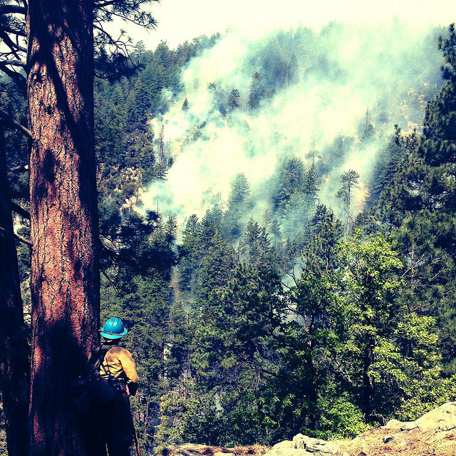
A burn out operation will be initiated tonight and is part of the overall containment strategy on the NW section of the fire. The idea is to create an area northwest of the main fire that circles the deep canyons, including West Fork of Oak Creek, keeping firefighters out of very hazardous terrain. When burnout operations are completed, it will halt the main fire as it approaches, because of the lack of fuel. Although this strategy will increase the total fire acreage it also lessens impacts to natural resources and provides for the safety of firefighters. These actions are taking place because firefighter and public safety are our number one priority.
Firefighters plan to conduct burnout operations overnight while atmospheric conditions dampen fire intensity.
Size: Approximately 7,500 acres.
Containment: 5%
Location: Originated just about 4 to 5 miles north of Sedona, just north of Slide Rock State Park.
Date Reported: Tuesday, May 20 at approximately 4 p.m.
Cause: Human caused, under investigation
Structures Threatened: Approximately 300 structures, private homes, vacation resort cabins, and a Forest Service lookout tower. To date no structures have been lost.
Injuries: No injuries reported.
Current Resources: Approximately 850 personnel including 15 hotshot crews, 33 engines, three air tankers, five helicopters, two air attack, and other resources.
Closures:
- Highway 89A from Sedona to Fort Tuthill in Flagstaff
- Forest Road (FR) 535 at Highway 89A
- FR 533 at Highway 89A
- FR 231 at Rogers Lake
- FR 527 and 530 (west side; Volunteer Canyon area)
- Casner Mountain is closed to all vehicles
Evacuations: Evacuations remain in place in Oak Creek Canyon from Slide Rock State Park to Sterling Springs Hatchery. Coconino County issued a pre-evacuation notice to residents of Kachina Village and Forest Highlands subdivisions. Residentsare advised to be prepared to evacuate. County Emergency Management encourages those in the affected neighborhoods to begin packing important items they may need for several days. These items include prescriptions, important papers, any special dietary needs and pets. No new evacuations are in place at this time.
Coconino County is reminding people to register their cellphone number with the County’s CodeRED emergency notification system at www.coconino.az.gov/emergency. Only those residents whose numbers are registered will receive a direct phone call about any type of pre- or mandatory evacuation order.
For information on air quality, please visit the Arizona Department of Environmental Quality website at: http://wildlandfire.az.gov
###
![]() Sedona AZ (May 23, 2014) – MIDDAY UPDATE – A community meeting on the Slide Fire will be held this afternoon at 4p.m. in Sedona at the Red Rock High School Performing Arts Center, 995 Upper Red Rock Loop Road.
Sedona AZ (May 23, 2014) – MIDDAY UPDATE – A community meeting on the Slide Fire will be held this afternoon at 4p.m. in Sedona at the Red Rock High School Performing Arts Center, 995 Upper Red Rock Loop Road.
Work continues along FSR 231 and FSR 535 to prepare for burnout operations. Firefighters are utilizing aerial ignitions by helicopter and continuing ground burnout operations on the north and west flanks. Aerial ignitions are applied to the top of slopes; it creates a low intensity fire that backs slowly down the canyon to prevent fire from gaining momentum upslope. Crews continue to protect structures in Oak Creek Canyon.
Over a hundred spot fires were found last night with an infrared flight north of the fire. Crews were able to line and mop-up the spots easily due to past fuel treatments in the area.
Firefighter safety is our number one priority. Due to the extreme terrain, our suppression strategy is to create containment lines in safer areas far ahead of the fire, reinforcing these lines with low-intensity burnout operations. This means fire managers are expecting the size of the fire’s footprint to greatly increase, but many areas will receive much lighter fire behavior.
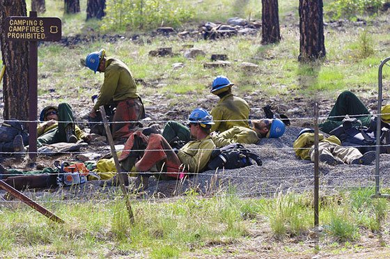
For information on air quality, please visit Arizona Department of Environmental Quality at:
No new information regarding size and containment at this time.
All closures and evacuations remain the same.
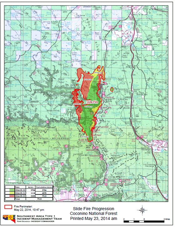
###
![]() Sedona AZ (May 23, 2014) – 7am UPDATE – The Slide Fire is located in Oak Creek Canyon just north of Slide Rock State Park and burning northward, up the canyon into places such as West Fork and Harding Point.
Sedona AZ (May 23, 2014) – 7am UPDATE – The Slide Fire is located in Oak Creek Canyon just north of Slide Rock State Park and burning northward, up the canyon into places such as West Fork and Harding Point.
Overnight: Crews made good progress overnight conducting burnout operations along the north and east flanks of the fire. Several small spot fires were contained south of FSR 535 through the evening hours. Additional burnout operations were conducted starting near the upper canyon ‘switchbacks’ on Highway 89A southward to the Fish Hatchery.
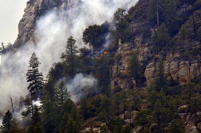
Today: Firefighters will continue working in the East Pocket area to the southwest using possible retardant and water drops in the rugged terrain. Prep work will also continue along FSR 231 and FSR 535 in preparation for aerial ignitions and ground burnout operations to the north and west flanks. Forming a ‘catcher’s mitt’ to the northwest, this suppression strategy will significantly increase acreage, but is essential to firefighter safety in extreme canyon terrain. Safety remains the number one priority in all wildfire operations. Fire managers anticipate lower intensity fire behavior within the ‘catcher’s mit’ containment lines. Crews will also work to hold hand and dozer line completed overnight near the Fish Hatchery. If conditions permit, crews may conduct burnouts near Slide Rock State Park to secure the southernmost containment lines.
Size: Approximately 7,500 acres.
Containment: 5%
Location: Originated just about 4 to 5 miles north of Sedona, just north of Slide Rock State Park.
Date Reported: Tuesday, May 20 at approximately 4 p.m.
Cause: Human caused, under investigation
Law Enforcement is seeking any information the public may have regarding the start of the Slide Fire and anyone of suspicion in the area on the day the fire started between Slide Rock State Park and Half Way Picnic Area. The public should call Forest Service Law Enforcement at 928-527-3511 if they have any information that might assist law enforcement in the investigation.
Structures Threatened: Approximately 300 structures, private homes as well vacation resort cabins and a Forest Service lookout tower.
Injuries: No injuries reported.
Current Resources: Approximately 840 personnel including 15 hotshot crews, 33 engines, three air tankers, five helicopters, two air attack, and other resources.
Closures:
- Highway 89A from Sedona to Fort Tuthill in Flagstaff
- Forest Road (FR) 535 at Highway 89A
- FR 533 at Highway 89A
- FR 231 at Rogers Lake
- FR 527 and 530 (west side; Volunteer Canyon area)
- Casner Mountain is closed to all vehicles
Evacuations: Evacuations remain in place in Oak Creek Canyon from Slide Rock State Park to Sterling Springs Hatchery. Coconino County issued a pre-evacuation notice to residents of Kachina Village and Forest Highlands subdivisions. Residentsare advised to be prepared to evacuate. County Emergency Management encourages those in the affected neighborhoods to begin packing important items they may need for several days. These items include prescriptions, important papers, any special dietary needs and pets. No new evacuations are in place at this time.
Coconino County is reminding people to register their cellphone number with the County’s CodeRED emergency notification system at www.coconino.az.gov/emergency. Only those residents whose numbers are registered will receive a direct phone call about any type of pre- or mandatory evacuation order.
###
![]() Sedona AZ (May 22, 2014) – EVENING UPDATE – The Slide Fire is located in Oak Creek Canyon just north of Slide Rock State Park and burning northward, up the canyon into places such as West Fork and Harding Point.
Sedona AZ (May 22, 2014) – EVENING UPDATE – The Slide Fire is located in Oak Creek Canyon just north of Slide Rock State Park and burning northward, up the canyon into places such as West Fork and Harding Point.
Today:
Crews continued to hold the fire west of Highway 89A and south of Fry Canyon. A small spot fire occurred across the northern line into an area that was previously thinned in 2006. Because this area was previously treated, the spot fire was unable to grow and crews quickly extinguished it.
Hotshot crews also worked to create fire line across the Pumphouse Wash near the Hwy 89A ‘switchbacks’ to control the east flank and prevent further spread east. Winds increased to 18-22mph with gusts of 32, temperatures were in the 70s. As the day continued to warm, firefighters saw an increase in fire behavior, with the most active portion of the fire toward the northwest to Harding Point. Firefighters observed active fire in the East Pocket area, but previously dropped retardant was able to help control growth.

Tonight:
Firefighters will be working throughout the lower canyon to monitor fire activity and conduct burnout operations as necessary. Overnight downslope winds will likely continue to drive the fire down canyon. Erratic winds may also be present producing moderate to high fire behavior. Crews will continue to work along FSR 535 and FSR 231 preparing for additional burnout operations tomorrow.
Size: Approximately 7,500 acres.
Containment: 5%
Location: Originated just about 4 to 5 miles north of Sedona, just north of Slide Rock State Park.
Date Reported: Tuesday, May 20 at approximately 4 p.m.
Cause: Human caused, under investigation
Law Enforcement is seeking any information the public may have regarding the start of the Slide Fire and anyone of suspicion in the area on the day the fire started between Slide Rock State Park and Half Way Picnic Area. The public should call Forest Service Law Enforcement at 928-527-3511 if they have any information that might assist law enforcement in the investigation.
Structures Threatened: Approximately 300 structures, private homes as well vacation resort cabins and a Forest Service lookout tower.
Injuries: No injuries reported.
Current Resources: Approximately 840 personnel including 15 hotshot crews, 33 engines, three air tankers, five helicopters, two air attack, and other resources.
Closures:
- Highway 89A from Sedona to Fort Tuthill in Flagstaff
- Forest Road (FR) 535 at Highway 89A
- FR 533 at Highway 89A
- FR 231 at Rogers Lake
- FR 527 and 530 (west side; Volunteer Canyon area)
- Casner Mountain is closed to all vehicles
Evacuations: Evacuations remain in place in Oak Creek Canyon from Slide Rock State Park to Sterling Springs Hatchery. Coconino County issued a pre-evacuation notice to residents of Kachina Village and Forest Highlands subdivisions. Residents are advised to be prepared to evacuate. County Emergency Management encourages those in the affected neighborhoods to begin packing important items they may need for several days. These items include prescriptions, important papers, any special dietary needs and pets. No new evacuations are in place at this time.
Coconino County is reminding people to register their cellphone number with the County’s CodeRED emergency notification system at www.coconino.az.gov/emergency. Only those residents whose numbers are registered will receive a direct phone call about any type of pre- or mandatory evacuation order.
###
![]() Sedona AZ (May 22, 2014) – AFTERNOON UPDATE – A community meeting will be held this evening at 6 p.m. at the Sinagua Middle School in Flagstaff.
Sedona AZ (May 22, 2014) – AFTERNOON UPDATE – A community meeting will be held this evening at 6 p.m. at the Sinagua Middle School in Flagstaff.
Crews are continuing to hold the fire west of Highway 89A and south of Fry Canyon. Burnout operations have been conducted south of FSR 535 to create a larger fire break north east of the fire. Hotshot crews are also working to create fire line across the Pump House Wash near the 89A “switchbacks” to control the east flank and prevent further spread east. Winds have become lighter today, with temperatures in the low 70s. As the day continues to warm, firefighters expect increased fire behavior, with the most active portion of the fire toward the northwest to Harding Point.
Heavy smoke is likely again in the greater Flagstaff area, Williams as well as Sedona and Oak Creek Canyon. Residents and motorists are asked to use caution as visibility may be limited at times.
For more information on road conditions and visibility visit Arizona Department of Transportation on Twitter: @arizonaDOT, on their 511 information page: and you can call their information phone line at 1-888-411-7623
For information on air quality, please visit Arizona Department of Environmental Quality at:
No new information regarding size and containment at this time.
Law Enforcement is seeking any information the public may have regarding the start of the Slide Fire and anyone of suspicion in the area yesterday between Slide Rock State Park and Half Way Picnic Area. The public should call Forest Service Law Enforcement at 928-527-3511 if they have any information that might assist law enforcement in the investigation.
Closures:
- Highway 89A from Sedona to Fort Tuthill in Flagstaff
- Forest Road (FR) 535 at Highway 89A
- FR 533 at Highway 89A
- FR 231 at Rogers Lake
- FR 527 and 530 (west side; Volunteer Canyon area)
- Casner Mountain is closed to all vehicles
Evacuations: Evacuations remain in place in Oak Creek Canyon from Slide Rock State Park to Sterling Springs Hatchery. Pre-evacuation notice continues for residents of Kachina Village and Forest Highlands. Residents are advised to be prepared to evacuate. County Emergency Management encourages those in the affected neighborhoods to begin packing important items they may need for several days. These items include prescriptions, important papers, any special dietary needs and pets. No new evacuations are in place at this time.
Coconino County is reminding people to register their cellphone number with the County’s CodeRED emergency notification system at www.coconino.az.gov/emergency. Only those residents whose numbers are registered will receive a direct phone call about any type of pre- or mandatory evacuation order.
###
![]() Sedona AZ (May 22, 2014) – 7am UPDATE – The Slide Fire is located in Oak Creek Canyon just north of Slide Rock State Park and burning northward, up the canyon into places such as West Fork and Harding Point.
Sedona AZ (May 22, 2014) – 7am UPDATE – The Slide Fire is located in Oak Creek Canyon just north of Slide Rock State Park and burning northward, up the canyon into places such as West Fork and Harding Point.
Yesterday: Fire managers saw very active fire behavior including runs, spotting, and torching as the fire became established in the upper Sterling Canyon area. Crews quickly responded with burnout operations along FSR 535 west to HWY 89A to the north. Fire retardant was also used heavily in steep terrain along the west flank with good results. The fire transitioned to a Type I Incident Management Team bringing many additional resources to the fire.
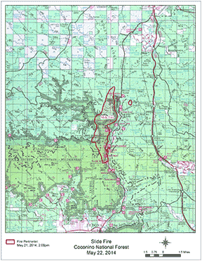 Last night: Cooler temperatures and higher relative humidity moderated fire behavior. Crews completed burnout operations north of the fire.
Today: Firefighters are concentrating on holding the fire west of Highway 89A and south of Fry Canyon. Firing operations will likely continue in these areas as crews work to hold work completed yesterday. Additional work may include potential firing operations along the upper 89A ‘switchbacks’ to hold the northeast fire flank. Winds are forecast to be lighter today, with temperatures to be similar to yesterday. As the day warms, firefighters expect increased fire behavior, with the most active portion of the fire toward the northwest to Harding Point.
Heavy smoke is likely again in the greater Flagstaff area. Residents and motorists are asked to use caution as visibility may be limited at times.
Size: 4,830 acres.
Containment: 0%
Location: Originated just about 4 to 5 miles north of Sedona, just north of Slide Rock State Park.
Date Reported: Tuesday, May 20 at approximately 4 p.m.
Cause: Human caused, under investigation
Law Enforcement is seeking any information the public may have regarding the start of the Slide Fire and anyone of suspicion in the area yesterday between Slide Rock State Park and Half Way Picnic Area. The public should call Forest Service Law Enforcement at 928-527-3511 if they have any information that might assist law enforcement in the investigation.
Structures Threatened: Approximately 300 structures, private homes as well vacation resort cabins and a Forest Service lookout tower.
Injuries: No injuries reported.
Current Resources: Approximately 840 personnel including 15 hotshot crews, 33 engines, three air tankers, five helicopters, two air attack, and other resources.
Closures:
- Highway 89A from Sedona to Fort Tuthill in Flagstaff
- Forest Road (FR) 535 at Highway 89A
- FR 533 at Highway 89A
- FR 231 at Rogers Lake
- FR 527 and 530 (west side; Volunteer Canyon area)
- Casner Mountain is closed to all vehicles
Evacuations: Evacuations remain in place in Oak Creek Canyon from Slide Rock State Park to Sterling Springs Hatchery. Coconino County issued a pre-evacuation notice to residents of Kachina Village and Forest Highlands subdivisions. Residentsare advised to be prepared to evacuate. County Emergency Management encourages those in the affected neighborhoods to begin packing important items they may need for several days. These items include prescriptions, important papers, any special dietary needs and pets. No new evacuations are in place at this time.
Coconino County is reminding people to register their cellphone number with the County’s CodeRED emergency notification system at www.coconino.az.gov/emergency. Only those residents whose numbers are registered will receive a direct phone call about any type of pre- or mandatory evacuation order.
###
![]() Sedona AZ (May 21, 2014) – EVENING UPDATE, 4:30PM – The Slide Fire is located in Oak Creek Canyon just north of Slide Rock State Park and burning northward, up the canyon into places such as West Fork and Harding Point.
Sedona AZ (May 21, 2014) – EVENING UPDATE, 4:30PM – The Slide Fire is located in Oak Creek Canyon just north of Slide Rock State Park and burning northward, up the canyon into places such as West Fork and Harding Point.
Overview: This afternoon, firefighters began burn out operations off FSR 535 to create a defensible space between the fire and Hwy 89 and FSR 535. All air resources have been shut down due to high winds. Firefighters are concentrating on keeping the fire west of Highway 89A, minimizing impacts to structures and utilizing terrain and fuel features to fight the fire. Extreme fire behavior has been observed as the fire is well established in the upper end of Sterling Canyon. As the fire has reached Pumphouse Wash, Kachina Village and Forest Highlands residents were given a pre-evacuation notice. The fire is currently located approximately 3 to 4 miles from those subdivisions.
Smoke is heavy through Oak Creek Canyon and creating very hazy conditions in Flagstaff as the smoke moves mostly in a northern directly. Smoke will likely continue to drift north and be noticeable along I-17 as motorists approach northern Arizona.
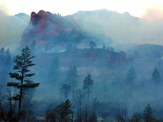
A Type I Incident Management Team will transition at 9 p.m.
Law Enforcement is seeking any information the public may have regarding the start of the Slide Fire and anyone of suspicion in the area yesterday between Slide Rock State Park and Half Way Picnic Area. The public should call Forest Service Law Enforcement at 928-527-3511 if they have any information that might assist law enforcement in the investigation.
Information regarding the Slide Fire will be updated on Inciweb as it becomes available: http://inciweb.nwcg.gov/state/3/
Size: Current official size is 4,500 acres.
Containment: 0%
Location: Originated just about 4 to 5 miles north of Sedona, just north of Slide Rock State Park.
Date Reported: Tuesday, May 20 at approximately 4 p.m.
Cause: Human caused, under investigation
Current Resources: Approximately 500 personnel including 15 hotshot crews, 20 – 30 engines, three air tankers, three Type I helicopters, one Type 3 helicopter, one air attack, 10 water tenders, Sedona Fire, a fuels crew, and two dozers.
Ordered Resources: One DC-10, 20 hotshot crews, 10 Initial Attack crews, 20 – 30 engines, one light helicopter, and additional overhead personnel.
Closures:
- Highway 89A from Sedona to Fort Tuthill in Flagstaff
- Forest Road (FR) 535 at Highway 89A
- FR 533 at Highway 89A
- FR 231 at Rogers Lake
- FR 527 and 530 (west side; Volunteer Canyon area)
- Casner Mountain is closed to all vehicles
Evacuations: Coconino County issued a pre-evacuation notice to residents of Kachina Village and Forest Highlands subdivisions. Residentsat this time are advised to prepare to evacuate from their homes. County Emergency Management encourages those in the affected neighborhoods to begin packing important items they may need for several days. These items include prescriptions, important papers, any special dietary needs and pets.
The County has set up a call center for the public to obtain general information about the impacts of the Slide Fire. For additional information, call 928-679-4173.
The County is reminding people to please register their cellphone number with the County’s CodeRED emergency notification system at www.coconino.az.gov/emergency. Only those residents whose numbers are registered will receive a direct phone call about any type of pre- or mandatory evacuation order.
An approximate 2 to 3-mile stretch of area from Slide Rock State Park north toward the Sterling Springs Hatchery was evacuated yesterday, as well as the East Pocket Forest Service Lookout Tower. Evacuees were relocated to Sinagua Middle School in Flagstaff.
Structures Threatened: Approximately 300 structures are currently threatened north of Slide Rock State Park, which include private homes as well vacation resort cabins and a Forest Service Lookout tower.
Injuries: No injuries reported.
###
![]() Sedona AZ (May 21, 2014) – ADEQ UPDATE, 3:30pm – Coconino County has issued a pre-evacuation order for Kachina Village and Forest Highlands Village subdivisions. Residents in the area are being asked to prepare for a mandatory to evacuation as Slide Fire has now reached Pumphouse Wash. Coconino County has established a call center, 928.679.4173.
Sedona AZ (May 21, 2014) – ADEQ UPDATE, 3:30pm – Coconino County has issued a pre-evacuation order for Kachina Village and Forest Highlands Village subdivisions. Residents in the area are being asked to prepare for a mandatory to evacuation as Slide Fire has now reached Pumphouse Wash. Coconino County has established a call center, 928.679.4173.
The Slide Fire is located about 4 to 5 miles north of Sedona in Oak Creek Canyon north of Slide Rock State Park and is burning northward up the canyon. The fire is burning into places such as West Fork and Harding Point.
Smoke is heavy through Oak Creek Canyon and creating hazy conditions in Flagstaff. Smoke will likely continue to drift north and be noticeable along I-17 approaching northern Arizona. Throughout the day, winds should move the smoke generally to the northeast. Flagstaff corruld continue to see smoke impacts throughout the day and overnight. Additionally, as overnight temperatures drop and winds die down, there will be a chance for smoke impacts down drainages in areas adjacent to the fire. Smoke should lift out as the sun rises and winds begin to pick up. The Arizona Department of Environmental Quality (ADEQ) is assessing the situation and may be placing additional smoke monitors in the area.
###
![]() Sedona AZ (May 21, 2014) – 11:15am UPDATE – The Slide Fire is located in Oak Creek Canyon just north of Slide Rock State Park and burning northward, up the canyon into places such as West Fork and Harding Point.
Sedona AZ (May 21, 2014) – 11:15am UPDATE – The Slide Fire is located in Oak Creek Canyon just north of Slide Rock State Park and burning northward, up the canyon into places such as West Fork and Harding Point.
Overview: Firefighters are concentrating on keeping the fire west of Highway 89A, minimizing impacts to structures and utilizing terrain and fuel features to fight the fire. Smoke is heavy through Oak Creek Canyon and creating very hazy conditions in Flagstaff as the smoke moves mostly in a northern directly. Smoke will likely continue to drift north and be noticeable along I-17 as motorists approach northern Arizona.
Winds are expected to be approximately 10-12 mph in Oak Creek Canyon today and gusts of 30 mph above the rim of the canyon.
A Type I Incident Management Team has been ordered and is expected to arrive at approximately 3 p.m. Public information will be handled by the team and new points of contact for Slide Fire information will be sent to members of the media once the team is established.
Law Enforcement is seeking any information the public may have regarding the start of the Slide Fire and anyone of suspicion in the area yesterday between Slide Rock State Park and Half Way Picnic Area. The public should call Forest Service Law Enforcement at 928-527-3511 if they have any information that might assist law enforcement in the investigation.
Information regarding the Slide Fire will be updated on Inciweb as it becomes available: http://inciweb.nwcg.gov/state/3/
Size: Current official size is 850 acres. However, acreage is expected to grow throughout the day and reach approximately 1,000 to 2,000 acres by nightfall. An accurate acreage count is usually determined by overflights that are conducting at night, so the next official acreage may not be available until the following morning of the flights.
Containment: 0%
Location: Originated just about 4 to 5 miles north of Sedona, just north of Slide Rock State Park.
Date Reported: Tuesday, May 20 at approximately 4 p.m.
Cause: Human caused, under investigation
Current Resources: Approximately 200 personnel including five hotshot crews, three air tankers, three helicopters, one air attack, 10 engines, two water tenders, Sedona Fire, a fuels crew and two dozers.
Ordered Resources: One Type 1 Incident Management Team, 15 hotshot crews, 10 Initial Attack crews, 40 engines, one light helicopter and additional overhead personnel.
Closures (updated May 21, 4:00pm):
- Highway 89A from Sedona to Fort Tuthill in Flagstaff
- Forest Road (FR) 535 at Highway 89A
- FR 533 at Highway 89A
- FR 231 at Rogers Lake
- FR 527 and 530 (west side; Volunteer Canyon area)
- Casner Mountain is closed to all vehicles
Evacuations: An approximate 2 to 3-mile stretch of area from Slide Rock State Park north toward the Sterling Springs Hatchery has been evacuated, as well as the East Pocket Forest Service Lookout Tower. Evacuees are being relocated to Sinagua Middle School in Flagstaff. There is no count as to how many individuals have been evacuated.
Structures Threatened: Approximately 100 structures are currently threatened north of Slide Rock State Park, which include private homes as well vacation resort cabins and a Forest Service Lookout tower.
Injuries: No injuries reported.
###
Sedona AZ (May 21, 2014) – 7:15am update – The Slide Fire is located in Oak Creek Canyon just north of Slide Rock State Park and burning northward, up the canyon.
A small 4 ½ acre fire, the Cookstove Fire, was reported late last night 2 miles northeast of the Slide Fire and is presumed to have started as a spot fire from the larger Slide Fire. Firefighters were able to create a line around the Cookstove Fire with a dozer at approximately 2 a.m.
A Type I Incident Management Team has been ordered and is expected to arrive at approximately 3 p.m.
Law Enforcement is seeking any information the public may have regarding the start of the Slide Fire and anyone of suspicion in the area yesterday between Slide Rock State Park and Half Way Picnic Area. The public should call Forest Service Law Enforcement at 928-527-3511 if they have any information that might assist law enforcement in the investigation.
Fire activity is slowing toward the north and now concentrating on moving up the steep canyon walls. Resources are stationed above and below the fire. Smoke is heavy through Oak Creek Canyon and creating very hazy conditions in Flagstaff. Smoke will likely continue to drift north and be noticeable along I-17 as motorists approach northern Arizona.
Information will be updated on Inciweb as it becomes available: http://inciweb.nwcg.gov/state/3/. Please select Slide Fire to view information.
Size: Approximately 400-450 acres
Containment: 0%
Location: Originated just north of Slide Rock State Park, approximately 4 to 5 miles north of Sedona.
Date Reported: Tuesday, May 20 at approximately 4 p.m.
Cause: Human caused, under investigation
Current Resources: Approximately 200 personnel including five hotshot crews, three helicopters, one air attack, 10 engines, two water tenders, Sedona Fire, a fuels crew and two dozers.
Ordered Resources: One Type 1 Incident Management Team, one air tanker en route, 15 hotshot crews, 10 Initial Attack crews, 40 engines and additional overhead personnel.
Closures: Highway 89A from Sedona to Fort Tuthill in Flagstaff. Forest Road 535 off Highway 89A. Power has been shut off by APS from Slide Rock, north through the canyon.
Evacuations: An approximate 2 to 3-mile stretch of area from Slide Rock State Park north toward the Sterling Springs Hatchery has been evacuated, as well as the East Pocket Forest Service Lookout Tower. Evacuees are being relocated to Sinagua Middle School in Flagstaff.
Structures Threatened: Approximately 100 structures are currently threatened north of Slide Rock State Park, which include private homes as well vacation resort cabins and a Forest Service Lookout tower.
Injuries: No injuries reported.
###
Sedona AZ (May 20, 2014) – 7:30 p.m. update (final for this evening) – The Slide Fire, reported just before 4 p.m. today, is located in Oak Creek Canyon just north of Slide Rock State Park and burning north up the canyon.
Size: Approximately 400-450 acres
Containment: 0%
Location: Originated just north of Slide Rock State Park, approximately 4 to 5 miles north of Sedona.
Date Reported: Tuesday, May 20 at approximately 4 p.m.
Cause: Human caused, under investigation
Current Resources: Approximately 100 personnel including two hotshot crews, two helicopters, one air attack, four engines, two water tenders, Sedona Fire and a fuels crew.
Ordered Resources: Four additional hotshot crews, three helicopters and additional overhead personnel are expected to arrive tomorrow.
Closures: Highway 89A from Sedona to Fort Tuthill in Flagstaff.
Evacuations: An approximate 2-mile stretch of area from Slide Rock State Park north toward Junipine has been evacuated, as well as the East Pocket Forest Service Lookout Tower. Evacuees are being relocated to Sinagua Middle School in Flagstaff.
Structures Threatened: Approximately 100 structures are currently threatened north of Slide Rock State Park, which include private homes as well vacation resort cabins and a Forest Service Lookout tower.
Fire activity is slowing toward the north and now concentrating on moving up the steep canyon walls. Resources are stationed above and below the fire. Smoke is heavy through Oak Creek Canyon and also visible from the Flagstaff area and will drift to the north; expect smoke to be noticeable along I-17 and in Flagstaff. No injuries to report.
###
Sedona AZ (May 20, 2014, 4:30pm) – The Slide Fire, reported just before 4 p.m. today, is currently estimated to be 20 acres, burning on the north side of Highway 89 in Oak Creek Canyon near Slide Rock State Park.
Multiple firefighting units are responding, including two Hotshot crews, four engines, two helicopters, an air attack unit and Sedona Fire.
Highway 89 may close to traffic near the Slide Rock area, and evacuations are being ordered for areas just north of Slide Rock State Park. It is unknown whether there are any structures threatened at this time.
The fire is currently moving to the north and fuel treatments in the area have kept the fire from aggressive activity.
Cause is unknown at this time.
7 Comments
I live at the Rainbow Trout Farm in Oak Creek Canyon. Yesterday morning (Tuesday, May 20) I woke up and checked the weather forecast which was predicting critical fire weather and red flag warnings. I recall thinking to myself—“wouldn’t it be great if Sedona were served by a Forest Service with the competency, foresight, and courage to restrict forest access during periods of critical fire weather—-when one errant cigarette from one of the 4 million tourists passing through this area could trigger a devastating wildlife?”
Now we have the Slide Fire—two devastating wildfires in the Sedona area in a relatively short span of time. I am dismayed that, after the Brins Fire, the Forest Service still doesn’t get it.
thanks for the updates… you are the best local source for news,,.
WE need a TV station now… cheers, Liberty
And despite the devastating losses to our natural resources and wildlife by the Slide Fire, which may have been prevented by restricted forest access, the Forest Service has just decided to continue to allow campfires in developed campgrounds in the Coconino National Forest over the upcoming M-Day weekend. The Prescott and Tonto National Forests have banned all campfires.
We appear to have a rogue local agency that has forgotten who its boss really is (the public).
Best for people not to come to Sedona…. smoke is very thick… in the mornings..
Stay away… it is not fun….
thanks to you Steve… luv Liberty
So Ron, should every forrest be closed during the summer due to extreme potential for fires, so just to keep you and those of you who CHOOSE to live in the middle of those areas happy? Anyway, I hear that the Daddy-O’s are mostly responsible for this fire coming under control. Once again the real heroes step up.
Good comment Juan, although I have no clue what a Daddy-O is. I was being very shortsighted when I mentioned I lived in Oak Creek Canyon in my original comment. It was not relevant. I don’t have property here—I rent. It was the only rental I could find at the time. I would have preferred to be in W. Sedona. The only reason I checked the weather forecast the morning of the fire was for my own safety and to stay informed. I have actually decided to leave OCC, since I would not want to go through this experience again.
I completely agree with you that people who live in the forest should not expect laws to be made just to protect them, since it was their choice to put their house there in the first place. Totally completely agree.
If by Daddy-O’s you mean the firefighters, I also agree. They are modern day heroes and true miracle workers.