
By Ted Grussing
As the USFS continues its Prescribed Burns, I believe it is fair to question the sanity of their policies of using fire as a tool in managing the forests, or at the least the way they are executing these policies.
I have no issues with natural fires in the forest, that is after all a natural part of life in forested areas. I believe they should be allowed to run their natural course unless human life is threatened, otherwise structures and the rest are fair game for fire. Living in a forest is a risk and steps need to be taken by those who live there to protect themselves. As part of my belief in allowing the natural events to play out I strenuously object to using artificial means to expand and continue natural fires that for example, may have been a fire of a few hundred acres and by using helicopters dropping incendiary devices and ground crews with drip torches, to expand it to say 36,000 acres like one fire crew did last year.
Numerous studies show how toxic wood smoke is to human health and because of the policies in effect, we are forced to breathe this airborne sewage. In another email I will include a number of these studies.
The justification they use is restoration of fire to the forest; rather than let nature take its course, they are intervening with this; cost is a principal reason for fire; there are numerous alternatives that will work, but they say it is not in the budget to use them. They totally neglect the cost to humans in health costs which if factored in would make the alternatives look cheap!
So what does it look like? Here are 8 photos I took this morning which depict the current state of air quality in Northern and Central Arizona as it is and as it is expected to be for a number of days to come. Anyone who is thinking about coming up here to see the natural beauty, well it ain’t going to be any better than this … and this sucks!
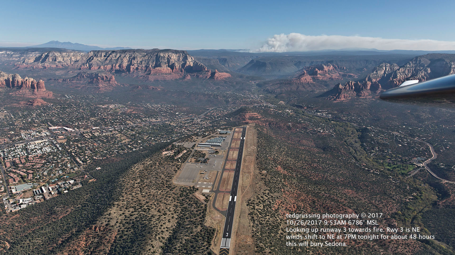
I took the first photograph (Burns 01)shortly after takeoff the morning and it is a line up with Rwy 3 at Sedona Airport looking straight up to the NE to a burn which includes fuel loading up to 100 tons per acre. The winds have currently reversed and all that smoke is on its way down into Sedona as I write this and we will likely be pretty well smoked out in the morning. All my windows are closed to keep the toxins out.
Burns 02 shows the burn and smoke plume, which at the time I took off had already penetrated New Mexico; partly it lifts up to be transported away from us to lucky recipients downwind … and of course tonight with the winds reversing it is coming back to us.

Burns 03 is another shot of the burn, but from a vantage further S of the last shot and it shows the smoke trail; about mid photo it is bumping over Mormon Mountain.

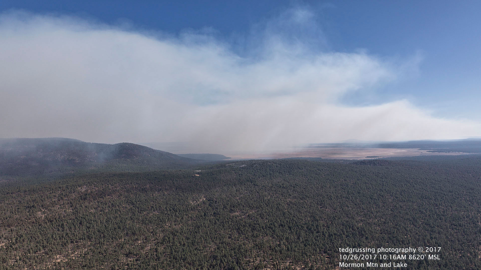
Burns 04 is downwind from the source and shows the smoke precipitating out and coming down to bury the Mormon Lake area as it comes over the mountain.
Burns 05 is looking a little S and E and shows two other burns in progress, one on the rim and the larger one about 100 miles out near Show Low, about 100 miles from where I took this shot and I understand that there are three other fires going out there. Please note that 100% of the surface area of the earth is blanketed in smoke.

Burn 06 is a shot I took while over Sedona on my way back to the airport and is a shot to the NNW and shows the effects of another fire in the Kaibab Forest and you can follow the smoke trail as Kendrick Peak and the San Francisco Peaks are obscured and Flagstaff is covered by a layer of smoke as well and to the N of the peaks it looks like the burn near Sedona. Wilson Mountain is in the lower right portion of the photograph.

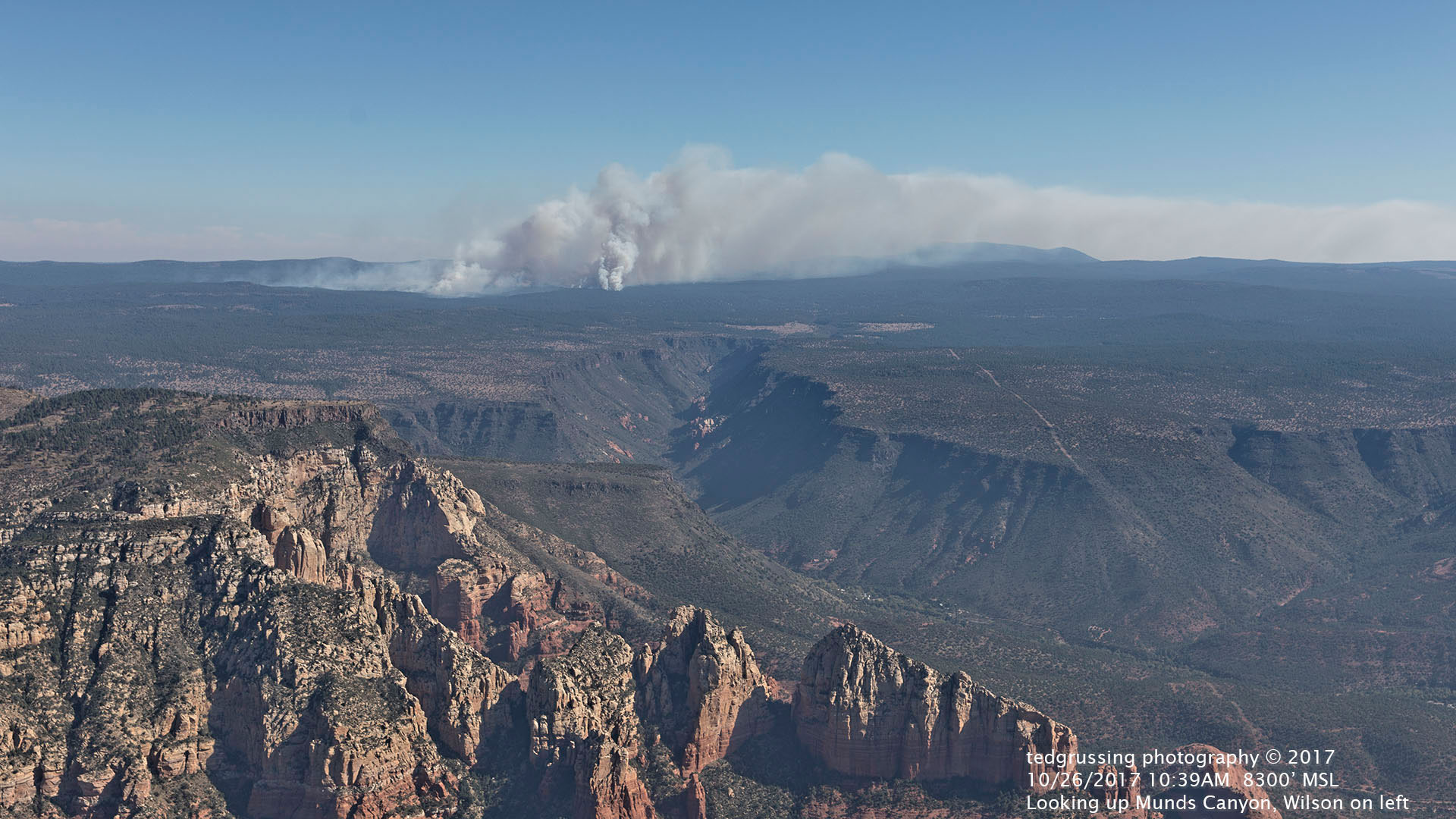
Burn 07 has Wilson Mountain in the lower left corner and you are looking up Munds Canyon towards the Rx burn nearest us.
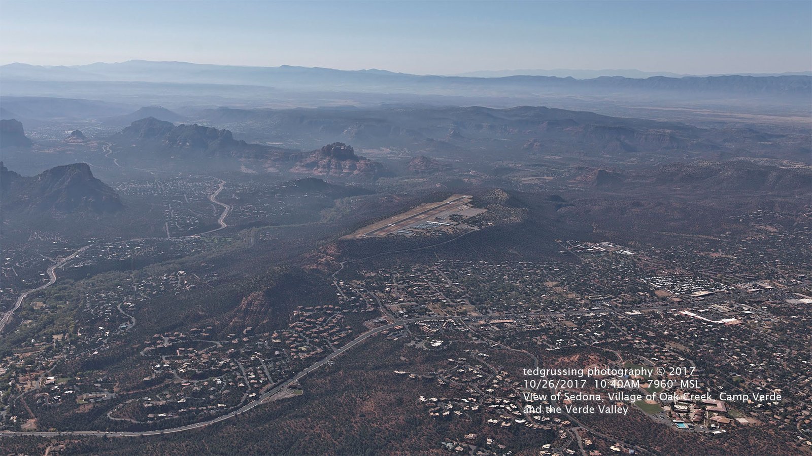
Burn 08 is a shot from about the same place, but looking to the SSE and has Sedona, the Village, other cities and the bulk of the Verde Valley in it. As you can see there is a layer of white smoke that covers everything. When you are on the ground and looking up, the sky looks pretty blue and clear; that is because you are looking through a relatively shallow layer of a thousand feet or so, but this shows what you really are breathing and it is not pretty. The red rocks don’t look very red!
So horizon to horizon, Northern and Central Arizona is blanketed in smoke. These are not natural fires, they are all prescribed fires and they were approved by the Arizona Department of Environmental Quality. Here is a link to the smoke portion of the website and there is a complaint form on the webpage … use it! http://azdeq.gov/programs/air-quality-programs/smoke-management
Each individual forest is served by a separate Forest Service District. This is a link where there is a hyperlink to every national forest in the USA. Please use it to register your opinion on what these prescribed burns are doing to you.https://www.thoughtco.com/complete-list-of-american-national-forests-1343075
It simply is not right for government to inflict this health hazard its citizens and that would be us. Little kids are getting this in their lungs and the smaller particles will be permanently lodged in their lungs!!! We have to breathe and this is what they are forcing us to breathe! Feel free to use these photos in filing complaints.
For sure it is into the weekend now. Smile and let’s see if we can get these insane policies changed.
Ted
So each one to his wish, and as for me,
I sit tonight and wait
To find the answers to my soul in me,
And in the beauty of the sky and sea.
— Max Ehrmann
###
The easiest way to reach Mr. Grussing is by email: ted@tedgrussing.com
In addition to sales of photographs already taken Ted does special shoots for patrons on request and also does air-to-air photography for those who want photographs of their airplanes in flight. All special photographic sessions are billed on an hourly basis.
Ted also does one-on-one workshops for those interested in learning the techniques he uses. By special arrangement Ted will do one-on-one aerial photography workshops which will include actual photo sessions in the air.
More about Ted Grussing …
1 Comment
Mr. Grussing; the forest service agrees with you; however, due to the previous policy of NOT allowing burns to run their course, our forests are clogged with low growth vegetation that burns longer and therefore encourages larger, more dangerous forest fires to take over.. The prescribed burns take place to eliminate the low growth so natural fires will burn out more easily. It is inconvenience to our visitors, but protects our area from larger, more destructive fires that are potentially far more damaging. Suck it up and have a late breakfast; the air generally clears after 10:00a.m. when the wind changes and the smoke clears.