
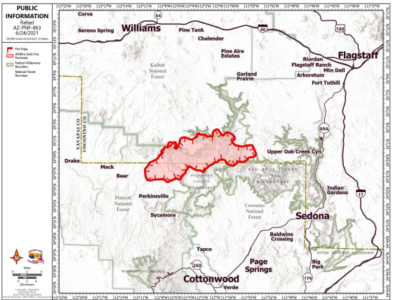
The Rafael fire has moved away from Sedona, advancing into Sycamore Canyon and moving on top to the Mogollon Rim on both the Kaibab National Forest on Sycamore Point and Coconino National Forests near Casner Mountain.
On the Prescott National Forest, the southwest corner of the fire has not advanced west or south for the last two days. Yesterday to the north on the Kaibab and Coconino National Forests, fire crews identified road systems to utilize as fire line to stop the spread north and westward towards identified values at risk. On the southeast portion of the fire in Sycamore Canyon and the Red Rock Secret Mountain Wilderness, crews are identifying fire line locations for direct and indirect suppression actions.
Personnel from the incoming Southwest Area Type 1 Incident Management Team 2 shadowed members of the Arizona Central West Zone Type 3 Team to transfer information and gain situational awareness of the Rafael fire. Type 1 Team 2 assumed management of the fire this morning at 6 a.m. Today, the fire is expected to move north in Sycamore Canyon near Dorsey Spring and east into Red Rock Secret Mountain Wilderness area, where vegetation and topography are in alignment. Fire fighters on the north end of the fire will continue with suppression efforts and prepare for future firing operations using road systems and natural features and will utilize aircraft to support these actions. In the Red Rock Secret Mountain Wilderness area, fire crews will continue to scout for future suppression lines.
Evacuation status as of 6 a.m. June 24:
“GO” in Coconino County, areas around Sycamore Canyon and SOUTH of Forest Service Road 535 off FS 231. In Yavapai County, some rural ranches in the area of North FSR 525 and Bill Grey Road, West of Sedona.
“SET” – in Coconino County, all areas south of 1-40, west of I-17, to include University Heights, Kachina Village, Forest Highlands, Pine Dell, & Woody Mountain Road, Camp Navajo, South Garland Prairie, Pine Aire Estates and residents in between. In Yavapai County, areas off Bill Gray Rd, Forest Road 525, Forest Road 152c north of AZ-89A, and the Grey Mountain and Bear Mountain area.
“READY” -none at this time. Notifications can change rapidly. Residents in areas affected by the fire should remain vigilant and be prepared to evacuate. Evacuation notifications are issued when danger is imminent and life threatening.
Information about evacuation status can be found on the Coconino County Emergency Management’s Facebook page at: https://www.facebook.com/coconinoEM/ and at the Yavapai County Sheriff’s Department Facebook page at: https://www.facebook.com/YavapaiCountySheriff/
Maps of evacuation status in Coconino County can be found at: Coconino County Situational Awareness Viewer (arcgis.com)
The Coconino National Forest has initiated a Forest Closure for the entire forest, effective 8 a.m. on June 23. Coconino National Forest – Alerts & Notices (usda.gov)
The Kaibab National Forest has initiated a Forest Closure for the entire forest, effective 8 a.m. on June 23. Kaibab National Forest – Alerts & Notices (usda.gov)
The Prescott National Forest will initiate a full Forest Closure effective Friday, June 25 at 8:00 a.m.. The forest will remain in Stage 2 Fire Restrictions until then, Prescott National Forest – Alerts & Notices (usda.gov)
All State Land is under Stage 2 restrictions effective 8 a.m. on June 11.
99
3 Comments
Like
Comment
Share