

Sedona News – UPDATE – May 29, 2023 – The Sedona-area Miller Fire is currently 31 percent contained at 30 acres and is experiencing minimal activity.
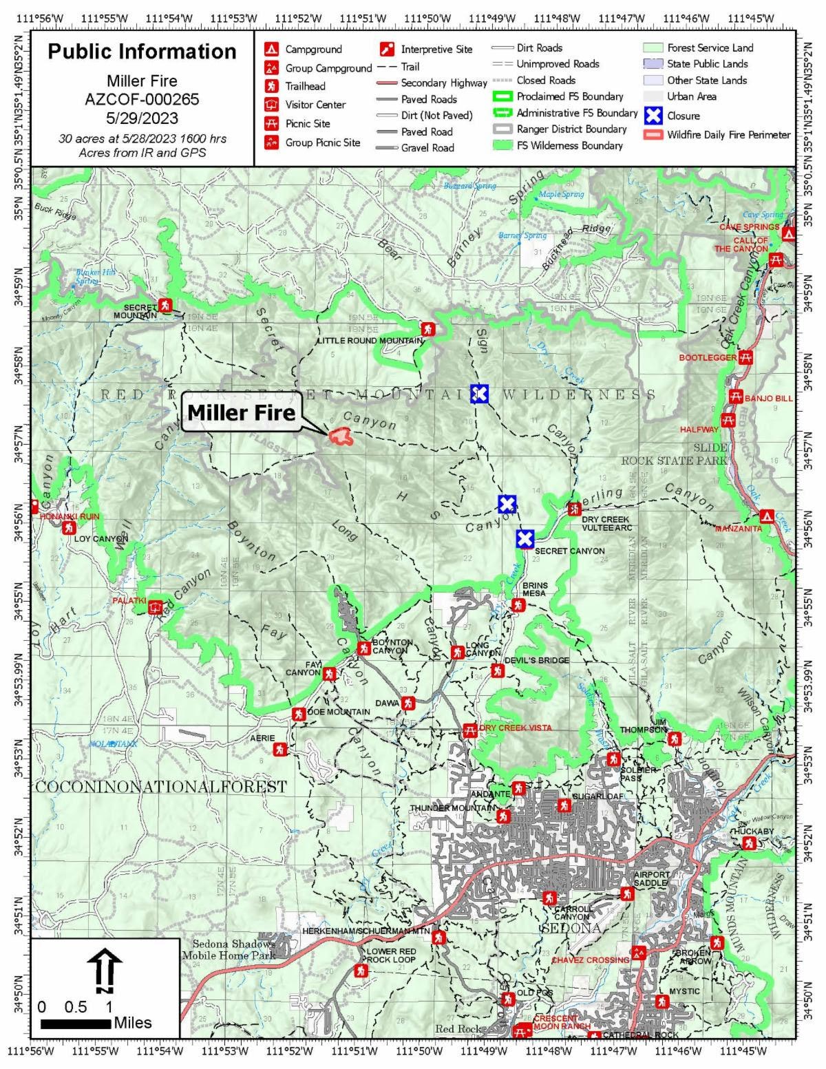 The lightning-caused fire is located in the Secret Mountain Wilderness of the Coconino National Forest’s Red Rock Ranger District (GPS coordinates: 34°57’21.2″N 111°50’05.6″W).
The Miller Fire is currently being managed by the Northern Arizona Type 3 Incident Management Team, which assumed control of the fire at 8 p.m. Friday. The team plans to transition management of the fire back to the Coconino National Forest 7 a.m. Tuesday.


A reduced closure order surrounding the fire area is being developed and will be posted Tuesday morning on the Coconino NF website. Forest visitors are reminded to check for area closures prior to any excursion and abide by all posted signage.
Current resources include one hand crew and one helicopter in addition to resource advisers and miscellaneous overhead.
Fire crews spent the last several days checking previously installed fire line along the south side of the fire in addition to aerially checking fire behavior.
Crews plan to install cameras and a monitoring system on the fire within the coming days so the RRRD can monitor fire behavior long-term, since hot spots are expected to persist in the area throughout the coming weeks due to high temperatures and weather conditions.
Though firefighters have not been inserted into the fire during the past three days, they have remained assigned to the fire in case an increase of fire activity dictates the need for further suppression efforts.
In addition to checking fire line, firefighters have spent the last three operational days scouting the area and collecting future intelligence regarding access routes, staging areas and helicopter landing sites. The information collected now will help in the future event of another wildfire in the Secret Mountain Wilderness area.
In addition to fire work, resource advisers are working to document and protect the natural features of the Secret Mountain Wilderness area. By documenting native wildlife and archaeological and heritage sites, resources advisers can provide guidance to ensure fire suppression efforts are as minimally disruptive to the landscape as possible.
The Miller Fire was last reported at 35 acres but has been adjusted due to more accurate mapping.
The acreage of emerging wildfires can vary for several reasons. Mapping is conducted either on the ground or aerially, and the method of mapping depends on the topography of the fire area.
If fire occurs on hike-able terrain, crews can physically walk the perimeter of a fire for an accurate acreage report.
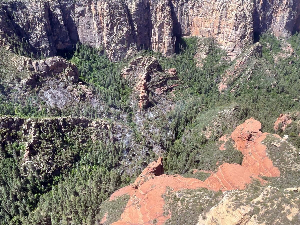
When a fire occurs in complicated terrain that includes cliffs, canyons and steep vertical drops – such as the Secret Mountain Wilderness – it is impossible to conduct on-the-ground mapping by foot. In those instances, mapping must be done aerially – often with a helicopter. Acreage estimates are created using either night infrared flights, or daytime visual flights. The additional challenges of aerial mapping include impeded visibility due to heavy smoke and unseen terrain.
Fire area topography can also create challenges for on-the-ground fire suppression efforts. The steep cliffs and canyons of the Secret Mountain Wilderness make it difficult to safely ingress and egress fire crews to certain areas of the fire, and vertical canyon walls make it impossible to create fuel breaks around the inaccessible areas of the fire perimeter.
While fire behavior is minimal, containment is listed at 31 percent due to the inaccessible portions of the fire’s perimeters.
The fire was first reported on May 20, but due to weather conditions, aerial resources were not able to confirm the fire until Monday, May 22.
There are no structures threatened by the fire.
While the Temporary Flight Restriction located in the Miller Fire area will likely be lifted soon, the use of drones is still prohibited in Forest Service wilderness areas, including the Secret Mountain Wilderness Area.
###
Lightning-caused Sedona-area Miller Fire at 35 acres
UPDATE – May 25, 2023 – The Miller Fire, located in the Secret Mountain Wilderness of the Coconino National Forest’s Red Rock Ranger District (GPS coordinates: 34°57’21.2″N 111°50’05.6″W), is now at roughly 35 acres.
A closure order has been issued for the area surrounding the fire, including Secret Mountain Loop Trails.
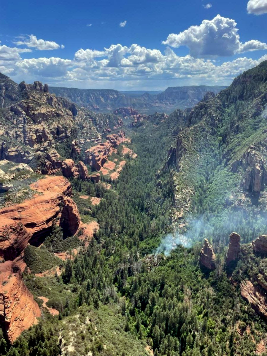
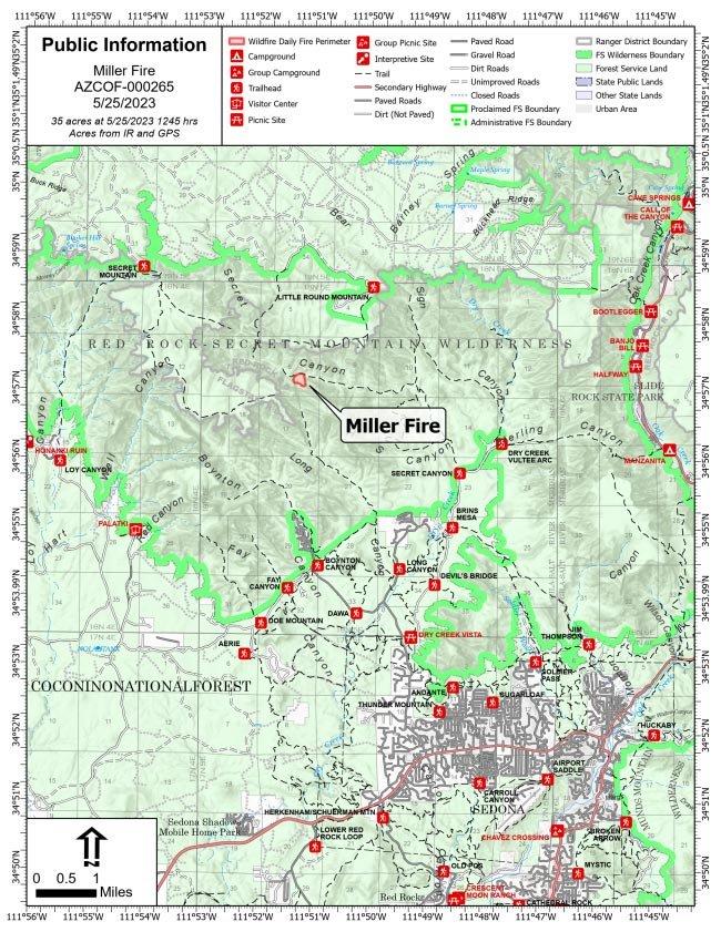 The Miller Fire is moving at a low rate of spread through brush, timber and rocky terrain southwest toward the south side of Secret Canyon and Maroon Mountain.

Current resources include one Hotshot crew, one hand crew, two engines, three helicopters and air attack.
Resources successfully established a control line on the eastern side of the fire in Secret Canyon Tuesday and spent Wednesday holding those lines while working to keep the fire south of Secret Canyon Creek.
Crews plan to continue working to directly suppress the fire at all accessible points and will evaluate inaccessible portions of the fire in order to respond when and if firefighting efforts can safely be carried out.
Rough and rocky terrain and steep cliff faces create challenges for on-the-ground fire suppression efforts. Predicted Friday wind gusts of up to 30 miles per hour may impede aerial operations.
The fire was first reported on May 20, but due to weather conditions, aerial resources were not able to confirm the fire until Monday, May 22.
There are no structures threatened by the fire.
Smoke impacts may be felt to the north and northeast of the fire. Light smoke is expected to settle into the Sedona area overnight.
###
Sedona-area Miller Fire at roughly 19 acres, resources responding
UPDATE – May 24, 2023 – The Miller Fire, located in the Secret Mountain Wilderness of the Coconino National Forest’s Red Rock Ranger District (RRRD) (GPS coordinates: 34°57’21.2″N 111°50’05.6″W), is now at roughly 19 acres.
 It is creeping and smoldering upslope and to the southwest toward the south side of Secret Canyon and Maroon Mountain at a low rate of spread.
Crews assigned to the fire include one Hotshot crew, two engines and two helicopters.
Resources successfully established a control line on the eastern side of the fire in Secret Canyon Tuesday, helping to stop the fire from spreading any further east.
Crews plan to spend today and the next several days working to hold control lines on the east side of the fire and work to suppress fire growth to the south. Rough and rocky terrain and steep cliff faces create challenges for on-the-ground fire suppression efforts.
The fire was first reported on May 20, but due to weather conditions, aerial resources were not able to confirm the fire until Monday, May 22. The cause of the fire is currently undetermined.
There are no structures threatened by the fire and smoke will remain visible.
The RRRD is working to implement trail closures for forest visitor safety, but until formal closure orders are issued, visitors are asked to avoid the fire area, including the Secret Mountain Loop Trails (Secret Canyon #121, David Miller #164, Bear Sign #59 and Dry Creek #52), the HS Canyon Trail #50 and Long Canyon Trail #122.
###
Resources monitoring quarter-acre Sedona-area fire – May 22, 2023
Resources are monitoring a quarter-acre fire located in the Secret Mountain Wilderness of the Coconino National Forest’s Red Rock Ranger District.
The Miller Fire, which was confirmed at 10:30 a.m. on Monday, May 22, is smoldering at a low intensity in heavy dead and down fuels, and is located about 4.5 miles west of Slide Rock State Park (GPS coordinates: 34°57’21.2″N 111°50’05.6″W).
The fire was first reported on May 20, but due to weather conditions, aerial resources were not able to confirm the fire until this morning.
Due to the lack of accessibility and potential thunderstorms, resources are monitoring the fire and developing strategic plans.
There are no structures threatened by the fire and smoke may be visible.
Additionally, there are no road or trail closures in effect, but visitors are asked to avoid the fire area.