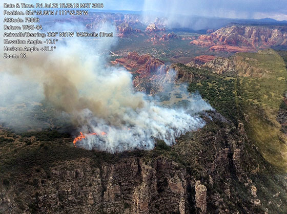
Sedona AZ (July 26, 2016) – UPDATE – Following aerial reconnaissance this morning, the Point Fire appears calm with some isolated burning within the fire area. Fire managers have determined not to staff firefighters on the ground and to reinforce existing fire-lines using helicopter water drops. The fire will continue to be monitored over the next several days.
Yesterday some precipitation occurred on the fire later in the day and crews were pulled off the fire due to approaching thunderstorms.

POINT FIRE OVERVIEW:
Current Size: Approximately 191 acres
Start Date: July 20, 2016
Cause: Lightning
Location: Munds Mountain Wilderness mesa, approximately 2.5 miles east/southeast of Sedona.
Containment: 70 percent
Trails Closed to hikers: Munds Mountain Trail and Jacks Canyon Trail
Resources: Two helicopters and 27 fire personnel assigned
Cooperating Agencies: Sedona Fire Department, Sedona Airport and the City of Sedona.
Public Updates: The public can get detailed updates as they become available at Inciweb at . Follow us on Twitter for quick headline updates at twitter.com/coconinonf.
###
Sedona AZ (July 25, 2016) – UPDATE – The Point Fire continues to burn in the Munds Mountain Wilderness located east of State Highway 179 and south of Sedona and Schnebly Hill Road.
No significant growth occurred yesterday given favorable weather conditions and helicopter water-drop assistance. Fire crews were also successful in safely completing a fire line to the north of the fire on Munds Mountain mesa.
“Today, fire operations will continue to utilize air attack and ground crews to secure the fire line along the rim in the current footprint to limit further spread,” said Incident Commander Trainee Aaron Graeser. “Firefighter safety continues to be our primary concern given difficult terrain, steep and heavily vegetated side canyons and the potential hazard of monsoon thunderstorms.”
An increase in smoke may be evident over the next several days as it continues to burn in areas that firefighters cannot access which may be visible from various parts of the Verde Valley and along Interstate 17.
For public and fire fighter safety, individuals are asked to be mindful of Munds Mountain and Jack Canyon trail closures. The public should also refrain from flying drones over or near the fire, as doing so will cease operations that are fighting the fire with water drops from the air.
POINT FIRE OVERVIEW:
Current Size: Approximately 191 acres
Start Date: July 20, 2016
Cause: Lightning
Location: Munds Mountain Wilderness mesa, approximately 2.5 miles east/southeast of Sedona.
Containment: 30 percent
Trails Closed to hikers: Munds Mountain Trail and Jacks Canyon Trail
Resources: One Type 1 Crew, three Helitack crews, two Fuels crews, four helicopters, three single engine air tankers and one engine crew; Total of approximately 55 firefighters
Cooperating Agencies: Sedona Fire Department, Sedona Airport and the City of Sedona.
Public Updates: The public can get detailed updates as they become available at Inciweb at . Follow us on Twitter for quick headline updates at twitter.com/coconinonf.
###
Sedona AZ (July 24, 2016) – The lightning-caused Point Wildfire is currently burning in Munds Mountain Wilderness on Munds mesa, which is located east of State Highway 179 and south of Sedona and Schnebly Hill road.
The fire is estimated at 190 acres and was ignited following several lighting storms that came through the area mid-week.
“Today we are focusing on stopping the northern progression of the wildfire,” said Nicole Branton, Red Rock District ranger. “This fire is in very difficult terrain that is dangerous to firefighting personnel, so we can expect to see smoke over the next several days as it continues to burn in areas that firefighters cannot access. Firefighter safety is our primary concern along with containing the fire on top of the mesa to prevent further spread into surrounding canyons.”
Smoke will also be visible from various parts of the Verde Valley and along Interstate 17 while firefighters work to contain the fire over the next few days.
Air attack helicopters and planes along with 55 firefighters are working to help slow progress across the mesa and to reduce its chance of moving into side canyons.
For public and fire fighter safety, the public is asked to acknowledge the closure area of Munds Mountain Trail and Jack Canyon trail are closed.
Drones cannot be flown over or near the fire, as doing so will cease operations that are fighting the fire with water drops from the air.
POINT FIRE OVERVIEW:
Current Size: Approximately 190 acres
Start Date: July 20, 2016
Cause: Lightning
Location: Munds Mountain Wilderness mesa, approximately 2.5 miles east/southeast of Sedona.
Trails Closed to hikers: Munds Mountain Trail and Jacks Canyon Trail
Resources: One Type 1 Crew, two Fuels crews, 3 helicopters, 3 aircraft; Total of approximately 55 firefighters
Public Updates: The public can get detailed updates as they become available at Inciweb at . Follow us on Twitter for quick headline updates at twitter.com/coconinonf.


