Firing operations on Still Fire resuming along Highway 87
Heavy smoke impact, possible road closures anticipated
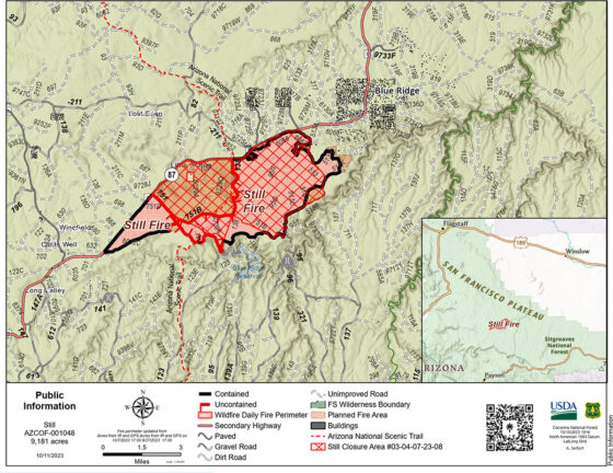
October 12, 2023 – UPDATE – Still Fire managers plan to resume firing operations Thursday and Friday along Highway 87 following several days of preparations during scattered showers and higher humidities.
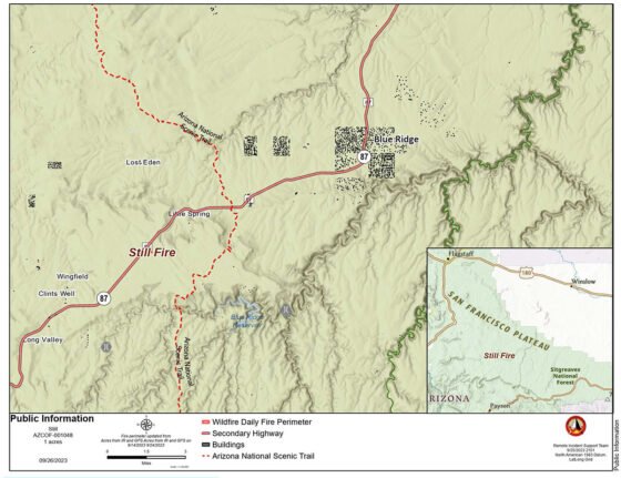
Fire managers plan to use strategic firing operations to increase containment and protect values at risk. The Still Fire is located 4 miles northeast of the Highway 87 and Lake Mary Road junction on the Coconino National Forest’s Mogollon Rim Ranger District (MRRD).
Once firing operations resume, local areas – including Highway 87, the Blue Ridge communities and the Little Springs area – will see heavy smoke impact.
Nearby areas, such as Payson, Pine and Strawberry may see moderate smoke impact as well.
Driving conditions in the fire area may remain hazardous, and possible intermittent closures may be implemented along area roads, including Highway 87, for public safety.
Forest Road (FR) 751 may be closed during firing operations Thursday and Friday, restricting access to C.C. Cragin (formerly Blue Ridge) Reservoir. FR 95 is expected to remain open but may see significant smoke impacts.
Motorists are reminded to check the Arizona Department of Transportation website for information regarding state road closures and to check the Coconino National Forest website for forest road information. Recreationists are asked to refer to the fire area closure order and to abide by all posted signage and barriers.
Containment for the Still Fire is at 62%.
The Still Fire is being managed to reduce hazardous fuels and improve forest health as guided by Forest Service’s 10-year Wildfire Crisis Strategy.
Current resources assigned to the Still Fire include one hand crew, seven engines, one dozer, one helicopter and miscellaneous overhead.
Forest visitors are asked to remain cognizant of firefighting operations.
There are no structures threatened by the Still Fire, which was first reported Sept. 14.
Area residents and MRRD visitors can visit InciWeb for updates regarding the Still Fire.
Information about smoke and smoke impact is available at fire.airnow.gov.
For additional information please contact the Still Fire public information team at 2023.still@firenet.gov.
###
Still Fire at 9,101 acres, firing operations on hold
Firing operations may resume following early week rains
October 8, 2023 – UPDATE – Fire managers are pausing firing operations on the Still Fire for the next several days due to predicted rain and humidity but are hoping to resume those operations later this week when weather conditions allow.
The Still Fire is a lightning-caused wildfire located 4 miles northeast of the Highway 87 and Lake Mary Road junction on the Coconino National Forest’s Mogollon Rim Ranger District (MRRD).
During the pause on firing operations, crews will continue to hold existing line while also preparing the fire area – including areas along Highway 87 – for firing operations.
Smoke impact will dwindle significantly over the coming days, but may remain noticeable along Highway 87, in the Blue Ridge communities and in the Little Springs area.
While fire managers anticipate that north and northeast winds – forecast during proposed Thursday and Friday firing operations – will direct smoke away from Highway 87 and local communities, heavy smoke impact may resume along with firing operations.
Driving conditions in the fire area may remain hazardous, and possible intermittent closures may be implemented along area roads, including Highway 87, for public safety.
Fire managers anticipate Forest Road (FR) 95 will remain open at this time, although FR 751 may close should aerial operations resume.
Motorists are reminded to check the Arizona Department of Transportation website for information regarding state road closures and to check the Coconino National Forest website for forest road information. Recreationists are asked to refer to the fire area closure order and to abide by all posted signage and barriers.
Containment for the 9,101-acre Still Fire is at 47 percent, with containment lines in place along the west and east portions of the fire perimeter.
The Still Fire is being managed to reduce hazardous fuels and improve forest health as guided by Forest Service’s 10-year Wildfire Crisis Strategy.
Current resources assigned to the Type 3 Still Fire include one Hotshot crew, one hand crew, six engines, one dozer, one helicopter and miscellaneous overhead.
Forest visitors are asked to remain cognizant of firefighting operations.
There are no structures threatened by the Still Fire, which was first reported Sept. 14.
Area residents and MRRD visitors can visit InciWeb for updates regarding the Still Fire.
Information about smoke and smoke impact is available at fire.airnow.gov.
For additional information please contact the Still Fire public information team at 2023.still@firenet.gov.
###
Still Fire at 8,648 acres, smoke impact subsiding
Minimal firing operations continuing through weekend
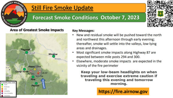
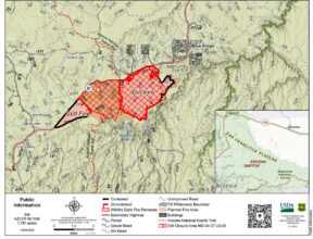
October 7, 2023 – UPDATE – Fire managers will continue conducting light firing operations on the interior portion of the Still Fire, a lightning-caused wildfire located 4 miles northeast of the Highway 87 and Lake Mary Road junction, throughout the weekend.
 Minimal smoke impact will remain noticeable during today’s operations along Highway 87, in the Blue Ridge communities and in the Little Springs area.
Smoke will settle into low-lying areas overnight, and heavier smoke impact may resume early next week.
Driving conditions in the fire area may remain hazardous, and possible intermittent closures may be implemented along area roads, including Highway 87, for public safety.
Fire managers anticipate Forest Road (FR) 95 will remain open at this time, although FR 751 may close should aerial operations resume.
Motorists are reminded to check the Arizona Department of Transportation website for information regarding state road closures and to check the Coconino National Forest website for forest road information. Recreationists are asked to refer to the fire area closure order and to abide by all posted signage and barriers.
Containment for the 8,648-acre Still Fire is at 38 percent, with containment lines in place along the west and east portions of the fire perimeter.
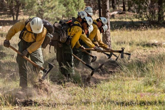
Crews plan to spend today and this weekend conducting small firing operations within the internal fire perimeter, as well as holding existing fire lines and preparing for the possibility of firing operations along Highway 87 early next week should wind and weather conditions allow.
The Still Fire is being managed to reduce hazardous fuels and improve forest health as guided by Forest Service’s 10-year Wildfire Crisis Strategy.
Today’s firing operations will contribute to the Still Fire’s objective of bolstering the health of the C.C. Cragin watershed. The management objectives of the Still Fire contribute to the overarching goal of the Cragin Watershed Protection Project, a long-term project that will reduce the risk of wildfire and post-fire flooding in the C.C. Cragin Reservoir watersheds.
Current resources assigned to the Type 3 Still Fire include one Hotshot crew, one hand crew, six engines, one dozer, one helicopter and miscellaneous overhead.
Forest visitors are asked to remain cognizant of firefighting operations.
There are no structures threatened by the Still Fire, which was first reported Sept. 14.
Area residents and Mogollon Rim Ranger District visitors can visit InciWeb for updates regarding the Still Fire.
Information about smoke and smoke impact is available at fire.airnow.gov.
For additional information please contact the Still Fire public information team at 2023.still@firenet.gov.
###
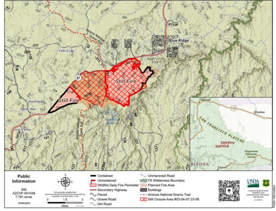
Still Fire at 7,781 acres, smoke impact to continue
Firing operations paused along Highway 87; may resume next week
October 6, 2023 – UPDATE – Smoke impact will linger despite a pause on Highway 87-adjacent firing operations on the Still Fire, a lightning-caused wildfire located 4 miles northeast of the Highway 87 and Lake Mary Road junction.
Smoke impact will remain noticeable along Highway 87, in the Blue Ridge communities, the Little Springs area, and possibly in the Camp Verde, Cottonwood, Pine, Strawberry and Payson areas.
Smoke will settle into low-lying areas overnight.
Driving conditions in the fire area may remain hazardous, and possible intermittent closures may be implemented along area roads, including Highway 87, for public safety.
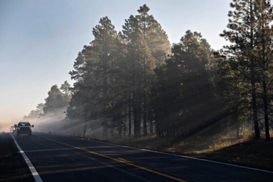
Fire managers anticipate Forest Road (FR) 95 will remain open at this time, although FR 751 may close should aerial operations resume.
Motorists are reminded to check the Arizona Department of Transportation website for information regarding state road closures and to check the Coconino National Forest website for forest road information. Recreationists are asked to refer to the fire area closure order and to abide by all posted signage and barriers.
Containment for the Still Fire is at 30 percent.
The Still Fire is being managed to reduce hazardous fuels and improve forest health as guided by Forest Service’s 10-year Wildfire Crisis Strategy.
Firing operations along Highway 87 may resume early next week should wind and weather conditions allow. Crews plan to spend today and this weekend conducting small firing operations within the internal fire perimeter, as well as holding existing fire lines and preparing for the possibility of Monday firing operations along Highway 87.
Firing operations remove hazardous fuels – such as downed trees and dead pine needle accumulation – from the forest floor. Firing operations occur during times of manageable winds and lower temperatures where low-intensity fire can safely remove those fuels prior to seasons of critical fire weather, where high winds, heavy drought and hot temperatures can lead to uncontrollable high-intensity wildfires.
Current resources assigned to the Type 3 Still Fire include one Hotshot crew, one hand crew, eight engines, one dozer, one helicopter and miscellaneous overhead.
Forest visitors are asked to remain cognizant of firefighting operations.
There are no structures threatened by the Still Fire, which was first reported Sept. 14.
Area residents and Mogollon Rim Ranger District visitors can visit InciWeb for updates regarding the Still Fire.
Information about smoke and smoke impact is available at fire.airnow.gov.
For additional information please contact the Coconino National Forest Supervisor’s Office at 928-527-3600 (staffed 8 a.m. to 4 p.m. Monday through Friday excluding federal holidays) or the Still Fire public information team at 2023.still@firenet.gov.
The MRRD’s Blue Ridge Ranger Station will be closed Friday due to smoke impact. It is expected that the station will reopen Tuesday following the holiday weekend.
###
Cecil Fire containment at 67%; area closure removed
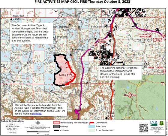
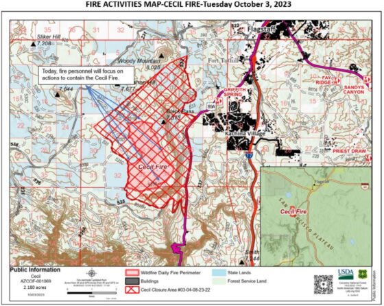
October 5, 2023 – UPDATE – Containment on the 2,180-acre lightning-caused Cecil Fire, located southwest of Flagstaff, is at 67% following yesterday’s containment and suppression repair efforts.
The Coconino National Forest has removed the emergency area closure for the Cecil Fire.
The Type 3 Incident Management Team that has been managing this fire since Sept. 28 will return the fire back to the Coconino NF this evening.
Forty-two personnel remain assigned to the Cecil Fire, including one 20-person crew, three engines and miscellaneous overhead.
Remaining personnel will be demobilized from the fire at the end of today’s shift.
The Cecil Fire treated 810 acres of Arizona State Trust land and 1,370 acres of Coconino NF land.
Land treatments – such as strategic wildfire management, planned prescribed fire projects and mechanical thinning – bolster the resiliency of the Coconino NF’s Flagstaff Ranger District by restoring it to healthy conditions that are resistant to high-intensity wildfire.
This, in turn, protects nearby communities located in the vulnerable wildland-urban interface.
The Cecil Fire is being managed by guidance issued in Forest Service’s 10-year Wildfire Crisis Strategy.
Fire will continue to burn throughout the interior of the Cecil Fire, but smoke impact will continue to lessen over time. For current information on smoke, visit the Fire and Smoke Map via airnow.gov.
The lightning-caused Cecil Fire was first reported Sept. 18.
This is the last news release that will be sent regarding the Cecil Fire. Fire information will remain accessible via InciWeb until containment reaches 100%.
###
Still Fire smoke impact, firing operations continuing today
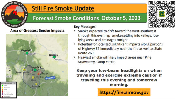
October 5, 2023 – UPDATE – Heavy smoke will continue throughout the day Thursday and into Friday as firing operations continue on the Still Fire, a lightning-caused wildfire located 4 miles northeast of the Highway 87 and Lake Mary Road junction.
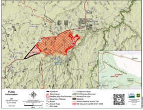 Heavy smoke impact will be felt in the Blue Ridge communities, the Little Springs area and along Highway 87.
Moderate smoke impact will be felt in the Camp Verde, Pine, Strawberry and Payson areas.
Minimal smoke may be noticed in the Cottonwood and Phoenix areas.
Smoke will settle into low-lying areas overnight.
Driving conditions in the fire area may become hazardous, and possible intermittent closures may be implemented along area roads, including Highway 87, for public safety.

Forest visitors are asked to remain cognizant of firefighting operations.
Motorists are reminded to check the Arizona Department of Transportation website for information regarding state road closures, and recreationists are asked to refer to the fire area closure order and to abide by all posted signage and barriers.
The Still Fire is currently 4,889 acres, and fire managers intend to treat an additional roughly 2,800 acres with firing operations today.
Containment for the Still Fire is at 26 percent.
Today’s planned firing operations will occur near the Coconino NF’s Blue Ridge Ranger Station and near the C.C. Cragin (formerly Blue Ridge) Reservoir.
Current resources assigned to the Type 3 Still Fire include one fuels crew, one Hotshot crew, eight engines, one hand crew, one dozer and miscellaneous overhead.
There are no structures threatened by the Still Fire, which is burning through pine litter and was first reported Sept. 14.
The Still Fire is being managed to reduce hazardous fuels and improve forest health as guided by Forest Service’s 10-year Wildfire Crisis Strategy.
Today’s firing operations will contribute to the Still Fire’s objective of bolstering the health of the C.C. Cragin watershed. The management objectives of the Still Fire contribute to the overarching goal of the Cragin Watershed Protection Project, a long-term project that will reduce the risk of wildfire and post-fire flooding in the C.C. Cragin Reservoir watersheds.
Area residents and MRRD visitors can visit InciWeb for updates regarding the Still Fire.
Information about smoke and smoke impact is available at fire.airnow.gov.
For additional information please contact the Coconino National Forest Supervisor’s Office at 928-527-3600 or the Still Fire public information team at 2023.still@firenet.gov.
###
Heavy smoke impact expected from Wednesday Still Fire operations
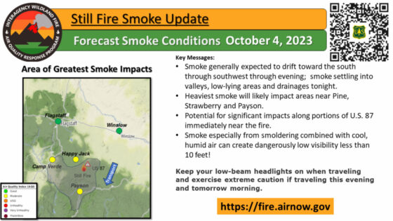
October 4, 2023 – UPDATE – Heavy smoke impact is expected today from firing operations on the Still Fire, a lightning-caused wildfire located 4 miles northeast of the Highway 87 and Lake Mary Road junction.
Heavy smoke impact will be felt in the Blue Ridge communities, the Little Springs area and along Highway 87.
Smoke is expected to drift toward the southeast to southwest of the fire today into tomorrow, and will impact the Pine, Strawberry and Payson areas.
Minimal smoke may be noticed in the Phoenix area.
Information about smoke and smoke impact is available at fire.airnow.gov.
Driving conditions in the fire area may become hazardous, and possible intermittent closures may be implemented along area roads, including Highway 87, for public safety.
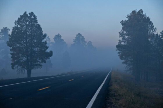
Motorists are reminded to check the Arizona Department of Transportation website for information regarding state road closures, and recreationists are asked to refer to the fire area closure order and to abide by all posted signage and barriers.
Forest visitors are asked to remain cognizant of firefighting operations.
Current resources assigned to the Type 3 Still Fire include one fuels crew, one Hotshot crew, eight engines, one hand crew, one dozer and miscellaneous overhead.
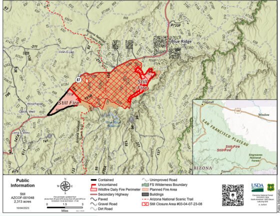
The Still Fire is currently 2,313 acres, and fire managers are hoping to treat an additional 4,000 acres with firing operations today.
The Still Fire is being managed to reduce hazardous fuels and improve forest health as guided by Forest Service’s 10-year Wildfire Crisis Strategy.
Land treatments – such as strategic wildfire management, planned prescribed fire projects and mechanical thinning – bolster the resiliency of the Coconino NF’s Mogollon Rim Ranger District (MRRD) by restoring it to healthy conditions that are resistant to high-intensity wildfire.
There are no structures threatened by the Still Fire, which is burning through pine litter and was first reported Sept. 14.
Area residents and MRRD visitors can visit InciWeb for updates regarding the Still Fire.
For additional information please contact the Coconino National Forest Supervisor’s Office at 928-527-3600 or the Still Fire public information team at 2023.still@firenet.gov.
###
Cecil Fire containment up to 21%, suppression repair work to begin
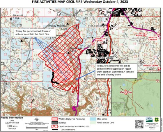
October 4, 2023 – UPDATE – Containment on the Cecil Fire jumped to 21% as firefighters continue working to contain the fire perimeter while also repairing areas damaged during suppression work on the 2,180-acre lightning caused Cecil Fire, located southwest of Flagstaff.
The Cecil Fire perimeter is located on both Coconino National Forest and Arizona State Trust lands, and a closure order has been issued for the fire area.
Resources assigned to the Cecil Fire include one Hotshot crew, two hand crews, 10 engines, a dozer, a water tender and miscellaneous overhead for a total of 112 personnel.
Crews switched to a full suppression strategy yesterday and began suppression repair work on hand and dozer lines located both in the Black Pass area and just south of Eightynine A Tank.
Fire personnel will continue working toward full containment today and aim to complete the suppression repair work south of Eightynine A Tank by the end of today’s shift.
Suppression repair work includes spreading slash created by line prep activities and removing berms from the edge of firelines and cutting waterbars so water drains off of firelines. These actions are designed to minimize erosion from suppression activities.
“Our goal with suppression repair work is to turn the fire area back to the way we found it, if not better” Incident Commander Steven Vankirk said. “We say ‘better,’ because in addition to restoring damage caused by equipment, this piece of land has now benefitted by landscape treatment to remove hazardous fuels.”
The Cecil Fire is being managed by guidance issued in Forest Service’s 10-year Wildfire Crisis Strategy.
Fire will continue to burn throughout the interior of the Cecil Fire, but smoke impact will continue to lessen over time. For current information on smoke, visit the Fire and Smoke Map via airnow.gov.
The lightning-caused Cecil Fire was first reported Sept. 18 and is burning in Ponderosa pine.
More information on the Cecil Fire can be found at InciWeb.
###
Burning operations suspended on Cecil Fire, firefighters working toward containment
October 3, 2023 – UPDATE – Cecil Fire managers will not resume firing operations on the 2,180-acre lightning-caused fire located southwest of Flagstaff, and have shifted to a strategy that will result in full containment as soon as possible.
The Cecil Fire is currently 0% contained and resources assigned to the Cecil Fire include four 20-person hand crews, 13 engines, a dozer, a water tender and miscellaneous overhead for a total of 147 personnel.
Fire managers for the Cecil Fire set early management objectives that included firing operations aimed at treating as much Coconino National Forest and Arizona State Trust land as possible during safe wind and weather conditions.
Land treatment includes a combination of strategically-managed wildfires, planned prescribed fire projects and mechanical thinning projects that restore landscape to healthy conditions.
Even without the additional treated acres that potential proposed firing operations would have provided, the 2,180-acre Cecil Fire was a “huge success,” District Ranger Matt McGrath said at last night’s public meeting.
The acreage treated during Cecil Fire operations will bolster planned land treatment projects in the Flagstaff wildland-urban interface area, McGrath added. These projects include prescribed fire projects such as Crater Sinks and West Fork, both of which were implemented in June and will have additional burning this spring in locations southwest of Flagstaff.
Wildland-urban interface land treatment projects help safeguard local communities against the effects of unplanned wildfire during seasons of critical fire weather, which often include heavy drought and high winds.
A closure order will remain in effect despite the change in operational plans.
The Cecil Fire is being managed by guidance issued in Forest Service’s 10-year Wildfire Crisis Strategy.
Fire will continue to burn on the interior of the Cecil Fire, but smoke emissions will continue to diminish over time. For current information on smoke, visit the Fire and Smoke Map via airnow.gov.
The lightning-caused Cecil Fire was first reported Sept. 18 and is burning in Ponderosa pine.
More information on the Cecil Fire can be found at InciWeb.
###
Still Fire firing operations resume October 3
October 3, 2023 – UPDATE – Fire managers on the Still Fire, a lightning-caused wildfire located 4 miles northeast of the Highway 87 and Lake Mary Road junction, are resuming firing operations today due to ideal wind and weather conditions.
Firefighters began conducting firing operations late last week before shifting to hold the fire within a 1,462-acre perimeter during high weekend winds while also preparing for this week’s firing operations.
Fire managers hope to treat a few hundred acres of land today with aspirations to treat as many needed acres as safely possible during ideal wind and weather conditions within the coming days.
Land treatments – such as strategic wildfire management, planned prescribed fire projects and mechanical thinning – bolster the resiliency of the Coconino NF’s Mogollon Rim Ranger District (MRRD) by restoring it to healthy conditions that are resistant to high-intensity wildfire.
Current resources assigned to the Still Fire include one fuels crew, one Hotshot crew, eight engines, one dozer and miscellaneous overhead. The Cecil Fire transitioned to a Type 3-level organization this morning.
Smoke will remain visible throughout the coming days in the Blue Ridge communities, along Highway 87, around the southern portion of Lake Mary Road and in the Little Springs area.
A closure order remains in effect for the fire area. Possible intermittent closures due to smoke impact may be implemented along area roads, including Highway 87.
Motorists are reminded to check the Arizona Department of Transportation website for information regarding state road closures, and recreationists are asked to refer to the existing closure order and to abide by all posted signage and barriers.
Forest visitors are asked to remain cognizant of firefighting operations.
There are no structures threatened by the Still Fire, which is burning through pine litter and was first reported Sept. 14.
MRRD visitors can visit InciWeb for updates regarding the Still Fire.
The Still Fire is being managed to reduce hazardous fuels and improve forest health as guided by Forest Service’s 10-year Wildfire Crisis Strategy.
###
Crews continue Cecil Fire prep work in anticipation of resuming burning operations this week
October 2, 2023 – UPDATE – The slight rain that fell on the Cecil Fire yesterday morning, October 1, helped keep the lightning-caused Cecil Fire, located southwest of Flagstaff, at 2,180 acres as of Monday morning.
The Cecil Fire is burning on both Coconino National Forest and Arizona State Trust lands, and a closure order has been issued for the fire area.
Resources assigned to the Cecil Fire include one Hotshot crew, two hand crews, 10 engines, a dozer, a water tender and miscellaneous overhead for a total of 112 personnel.
This week’s weather forecast looks favorable to possibly resume firing operations. In addition to holding existing lines, crews plan to spend today prepping lines for potential firing operations north of Black Pass on the north side of the fire, off Woody Ridge toward Forest Road (FR) 532B on the east side of the fire, and from Woody Ridge to just south of Eightynine A Tank.
The Cecil Fire Incident Management Team, the Coconino NF and the Arizona Department of Forestry and Fire Management will host a public meeting 6 p.m. today (Monday Oct. 2) at Sinagua Middle School, 3950 E. Butler Ave. in Flagstaff, to inform the community about Cecil Fire management and operations. The meeting will be live streamed on the Arizona Department of Forestry and Fire Management Facebook page at https://www.facebook.com/
The Cecil Fire is being managed by guidance issued in Forest Service’s 10-year Wildfire Crisis Strategy.
Smoke will remain noticeable in both the Flagstaff and Sedona areas as well as along 89A during the duration of this fire. For current information on smoke, visit the Fire and Smoke Map via airnow.gov.
###
Still Fire holding through winds
Fire managers plan to continue firing operations early next week when conditions allow
October 1, 2023 – UPDATE – Firefighters on the lightning-caused Still Fire, located 4 miles northeast of the Highway 87 and Lake Mary Road junction, are continuing to hold the fire within its current 1,462 acre perimeter during weekend winds.
The fire’s perimeter remains unchanged since firing operations ceased late last week.
Firefighters will continue to patrol the fire’s perimeter and secure existing lines until firing operations can safely resume within the coming days.
Current resources include five engines, one fuels crew, one Hotshot crew and one dozer. Roughly 60 personnel are assigned to the Still Fire, and more resources have been ordered to arrive as the fire transitions from a forest-level incident to a more complex Type 3-level organization.
Smoke will remain visible throughout the coming days as fire consumes interior pockets of unburned material as well as large heavy downed trees.
Smoke impact may increase as early as tomorrow when conditions improve to the point firing operations can resume.
Smoke impacts will remain noticeable in the Blue Ridge communities, along Highway 87, around the southern portion of Lake Mary Road and in the Little Springs area.
A closure order remains in effect for the fire area. Possible intermittent closures due to smoke impact may be implemented along area roads, including Highway 87.
Motorists are reminded to check the Arizona Department of Transportation website for information regarding state road closures, and recreationists are asked to refer to the existing closure order and to abide by all posted signage and barriers.
Forest visitors to remain cognizant of firefighting operations.
There are no structures threatened by the Still Fire, which is burning through pine litter and was first reported Sept. 14.
The Still Fire is being managed to reduce hazardous fuels and improve forest health as guided by Forest Service’s 10-year Wildfire Crisis Strategy.
###
Cecil Fire crews stay vigilant during wind event
Burning operations may resume next week; public meeting scheduled
October 1, 2023 – UPDATE – Firefighters have held the lightning-caused Cecil Fire, located southwest of Flagstaff, at 2,180 acres as of Sunday morning despite strong weekend winds.
Strong winds remain in the area forecast, with possible gusts up to 35 miles per hour expected again today.
The Cecil Fire is burning on both Coconino National Forest and Arizona State Trust lands, and a closure order has been issued for the fire area.
The fire area received light precipitation yesterday evening.
Resources assigned to the Cecil Fire include one Hotshot crew, two handcrews, 10 engines, a dozer, a water tender and miscellaneous overhead for a total of 110 personnel.
Firefighters patrolled and held existing fire lines Saturday into Sunday and will continue to secure the fire’s edge today.
Next week’s weather forecast looks favorable to possibly resume firing operations. In addition to holding existing lines, crews plan to spend today prepping lines for those potential firing operations north of Black Pass on the north side of the fire and off Woody Ridge toward Forest Road (FR) 532B on the east side of the fire.
Firing operations remove fuels – such as downed logs and pine needle accumulation – from the forest floor to reduce future the risk of high-intensity wildfire. These operations improve forest health long-term in our fire-adapted ponderosa pine ecosystem.
The Cecil Fire Incident Management Team, the Coconino NF and the Arizona Department of Forestry and Fire Management will host a public meeting 6 p.m. tomorrow (Monday Oct. 2) at Sinagua Middle School, 3950 E. Butler Ave. in Flagstaff, to inform the community about Cecil Fire management and operations.
The Cecil Fire is being managed by guidance issued in Forest Service’s 10-year Wildfire Crisis Strategy.
Smoke will remain noticeable in both the Flagstaff and Sedona areas as well as along 89A during the duration of this fire. For current information on smoke, visit the Fire and Smoke Map via airnow.gov.
The Cecil Fire was first reported Sept. 18.
For more information on the Cecil Fire InciWeb for fire updates throughout the coming days.
Smoke impact and future wildfire mitigation
The Coconino NF is a fire-adapted ecosystem, which needs incremental fire to maintain forest resiliency.
We recognize smoke can be impactful and inconvenient for area residents and visitors. Managing these fires and reducing the hazardous fuels in these areas of the forest under the current weather conditions will temporarily produce heavy smoke impacts, but it will also reduce the amount of fuel on the ground and help protect communities from high-intensity wildfires. If a future wildfire starts in this area, it will be more manageable and it will result in fewer overall smoke impacts to the communities.
###
Cecil Fire holding operations through weekend, looking to burn additional acres next week
September 30, 2023 – UPDATE – The acreage of the Cecil Fire, located southwest of Flagstaff, remains unchanged at 2,180 acres as of Saturday morning as crews continue to hold off on firing operations and focus on securing line during this weekend’s wind event.
The Cecil Fire is burning on both Coconino National Forest and Arizona State Trust lands, and a closure order has been issued for the fire area.
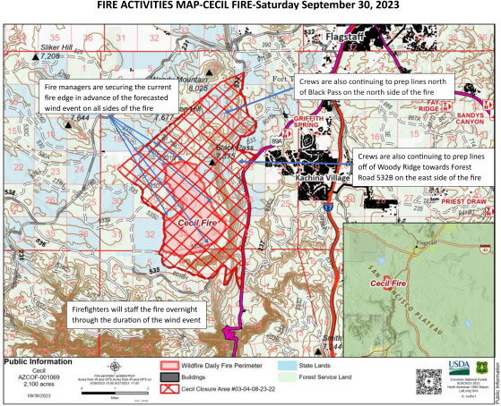
Fire managers spent Thursday and Friday holding the fire and are continuing to prep lines for possible future firing operations.
Firefighters will be deployed across the fire perimeter today to continue to secure the fire’s edge. Crews are also continuing to prep lines north of Black Pass on the north side of the fire and off Woody Ridge toward Forest Road (FR) 532B on the east side of the fire for the possibility of additional firing operations next week if conditions allow.
Firefighters will staff the fire overnight through the duration of the wind event. There are no structures at risk.
Firing operations removes fuels – such as dead trees and pine needle accumulation – from the forest floor to reduce the risk of high-intensity wildfire.
The Cecil Fire is being managed to reduce those hazardous fuels and improve forest health as guided by Forest Service’s 10-year Wildfire Crisis Strategy.
Resources assigned to the Cecil Fire include two Hotshot crews, two hand crews, six engines, a dozer, a water tender and miscellaneous overhead for a total of 111 personnel.
While smoke impact may decrease over the coming days, smoke will remain noticeable in both the Flagstaff and Sedona areas as well as along 89A. For current information on smoke, visit the Fire and Smoke Map via airnow.gov.
The Cecil Fire was first reported Sept. 18 and is burning in Ponderosa pine.
For more information on the Cecil Fire, visit InciWeb for fire updates throughout the coming days.
Smoke impact and future wildfire mitigation
The Coconino NF is a fire-adapted ecosystem, which needs incremental fire to maintain forest resiliency.
We recognize smoke can be impactful and inconvenient for area residents and visitors. Managing these fires and reducing the hazardous fuels in these areas of the forest under the current weather conditions will temporarily produce heavy smoke impacts, but it will also reduce the amount of fuel on the ground and help protect communities from high-intensity wildfires. If a future wildfire starts in this area, it will be more manageable and it will result in fewer overall smoke impacts to the communities.
###
Firefighters holding Still Fire as wind speeds pick up
Fire area closed to public; roads impacted by smoke
September 29, 2023 – UPDATE – Fire managers have successfully treated 1,462 acres of Mogollon Rim Ranger District (MRRD) land following three days of firing operations on the lightning-caused Still Fire, which is located 4 miles northeast of the Highway 87 and Lake Mary Road junction.
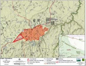 Crews finished firing operations Thursday evening and have pivoted to patrolling and holding lines as wind speeds pick up heading into the weekend.
A closure order has been put into effect for the fire area. Possible intermittent closures due to smoke impact may be implemented along area roads, including Highway 87.
“While it’s important to us to guard our local communities from future catastrophic wildfire by treating as much land as possible during ideal wind and weather conditions, we’re heading into less-than-ideal wind and weather conditions for firing operations,” said Incident Commander Adam White.
Land treatment removes fuels – such as dead trees and pine needle accumulation – from the forest floor to reduce the risk of high-intensity wildfire.
Roughly 41 personnel are assigned to the Still Fire, including three engines, one Hotshot crew, one fuels crew, a dozer and miscellaneous overhead.
Firing operations may continue next week following this weekend’s wind event if opportunities are available as MRRD land managers want to treat as much of the landscape as safely possible.
There are no structures threatened by the Still Fire, which is burning through pine litter and was first reported Sept. 14.
Smoke impacts will remain noticeable in the Blue Ridge communities, along Highway 87, around the southern portion of Lake Mary Road and in the Little Springs area.
Forest visitors to remain cognizant of firefighting operations. Recreationists area asked to abide by all posted signage and barriers, and motorists are reminded to expect traffic delays.
The Arizona Department of Transportation will be assisting motorists along Highway 87 during firing operations for public safety.
Highway 87 may close at any time for public safety and motorists are reminded to check the Arizona Department of Transportation website for information regarding state road closures.
The Still Fire is being managed to reduce hazardous fuels and improve forest health as guided by Forest Service’s 10-year Wildfire Crisis Strategy.
###
Firing operations paused on Cecil, Still fires in advance of weekend winds
Additional firefighters brought in to hold and secure lines
September 28, 2023 – UPDATE – Firefighters are halting firing operations on both the Cecil and Still fires in advance of forecast increased wind speeds.
Both fires have been staffed with additional firefighters who plan to spend the weekend holding and securing existing fire line.
So far, crews have successfully treated a combined 2,500 acres of Coconino National Forest land on both the Flagstaff Ranger District and the Mogollon Rim Ranger District due to both lightning-caused fires.
Land treatment removes fuels – such as dead trees and pine needle accumulation – from the forest floor to reduce the risk of high-intensity wildfire.
Both the Cecil and Still fires are being managed to reduce those hazardous fuels and improve forest health as guided by Forest Service’s 10-year Wildfire Crisis Strategy.
Still Fire
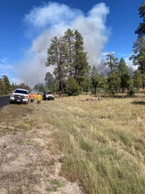 The Still Fire, located 4 miles northeast of the Highway 87 and Lake Mary Road junction, is roughly 300 acres following successful firing operations conducted Wednesday.
Fire managers are conducting firing operations on the Still Fire throughout the day today and aspire to have an additional 1,200 acres of land treated by the end of today’s operations.
Following today’s operations, crews will pivot and begin holding and securing existing fire line in advance of the weekend winds.
There are no structures threatened by the Still Fire, which is burning through pine litter.
Roughly 41 personnel are assigned to the Still Fire, including three engines, one Hotshot crew, one fuels crew, a dozer and miscellaneous overhead.
Forest visitors and motorists can expect smoke impacts in the Blue Ridge communities, along Highway 87 and in the Little Springs area.
The Arizona Department of Transportation will be assisting motorists along Highway 87 during firing operations for public safety.
Highway 87 may close at any time for public safety and motorists are reminded to check the Arizona Department of Transportation website for information regarding state road closures.
Motorists are asked to remain cognizant of firefighting operations and to expect traffic delays.
While there are no road, trail or area closures in effect at this time, a closure order will likely be implemented soon and forest visitors are asked to abide by all posted signage and barriers.
The Still Fire was first reported Sept. 14, and updates can be found on InciWeb.

Cecil Fire
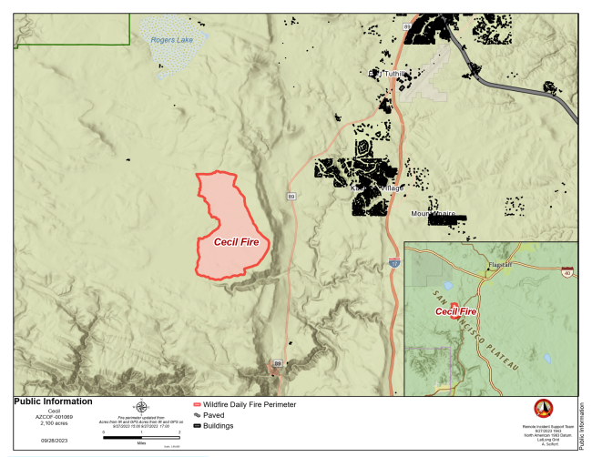
The Cecil Fire, located southwest of Flagstaff, was reported at 2,180 acres Thursday morning.
It is burning on both Coconino NF and Arizona State Trust lands, and a closure order has been issued for the fire area.
Fire managers do not plan to conduct additional firing operations this week due to a forecast increase in wind speeds. Fire managers are utilizing the next two days before the wind event to secure the current fire edge on all sides of the fire.
Relative humidities at night are in the 80-90% range, which saturate the fine fuels and decrease their ability to accept and spread fire, which is working in the firefighters’ favor.
Resources assigned to the Cecil Fire include two Hotshot crews, two hand crews, two engines, a dozer, a water tender and miscellaneous overhead.
One additional hand crew has been added to the resources already in place to help hold the fire during the wind event.
During the wind event, crews will be deployed across the fire perimeter to continue to secure the fires edge. Crews are also continuing to prep lines on the north and east sides of the fire for the possibility of additional firing operations next week if conditions allow.
While smoke impact will decrease over the coming days, smoke will remain noticeable in both the Flagstaff and Sedona areas as well as along 89A.
There are no structures at risk.
The Cecil Fire was first reported Sept. 18 and is burning in Ponderosa pine.
Flagstaff residents and Coconino NF visitors can check InciWeb for fire updates throughout the coming days.
Smoke impact and future wildfire mitigation
The Coconino NF is a fire-adapted ecosystem, which needs incremental fire to maintain forest resiliency.
We recognize smoke can be impactful and inconvenient for area residents and visitors. Managing these fires and reducing the hazardous fuels in these areas of the forest under the current weather conditions will temporarily produce heavy smoke impacts, but it will also reduce the amount of fuel on the ground and help protect communities from high-intensity wildfires. If a future wildfire starts in this area, it will be more manageable and it will result in fewer overall smoke impacts to the communities.
For current information on smoke, visit the Fire and Smoke Map via airnow.gov.
###
Firing operations continue on Cecil Fire; beginning on Still Fire
September 28, 2023 – UPDATE – Arizona News – Following a day of successful management actions on the Cecil Fire, located southwest of Flagstaff, crews plan to continue firing operations on the Cecil while also beginning firing operations on the Still Fire, located on the Coconino National Forest’s Mogollon Rim Ranger District.
Both the Cecil and Still fires are lightning-caused wildfires being managed to reduce hazardous fuels and improve forest health as guided by Forest Service’s 10-year Wildfire Crisis Strategy.
Due to the accumulated fuels in the fire areas, both wildfires will generate significant smoke during planned firing operations.
We recognize smoke can be impactful and inconvenient for area residents and visitors. Managing these fires and reducing the hazardous fuels in these areas of the forest under the current weather conditions will temporarily produce heavy smoke impacts, but it will also reduce the amount of fuel on the ground and help protect communities from high-intensity wildfires. If a future wildfire starts in this area, it will be more manageable and it will result in fewer overall smoke impacts to the communities.
The Coconino NF is a fire-adapted ecosystem, which needs incremental fire to maintain forest resiliency.
For current information on smoke, visit the Fire and Smoke Map via airnow.gov.
Cecil Fire:
The Cecil Fire was reported at 500 acres Wednesday morning, and firing operations are slated to continue today and possibly Thursday. The Cecil Fire is planned to grow to 2,100 acres by the end of this week’s management actions.
Fire managers do not plan to conduct firing operations past Thursday morning due to a forecast increase in wind speeds. Crews will spend the weekend securing lines around the fire’s perimeter.
Resources assigned to the Cecil Fire include two Hotshot crews, two engines, one engine crew, one hand crew, a water tender and miscellaneous overhead. More resources have been ordered to the fire to help with planned operations.
Smoke will remain highly visible from the Flagstaff and Sedona areas as well as along 89A. Smoke may settle into the Oak Creek Canyon area during the evening.
There are no structures at risk, and – while there is no closure order in place – forest visitors are asked to avoid the fire area while firefighters work.
The Cecil Fire was first reported Sept. 18 and is burning in Ponderosa pine.
Flagstaff residents and Coconino NF visitors can check InciWeb for fire updates throughout the coming days.
Still Fire:
The Still Fire has been slowly smoldering since Sept. 14 and was reported at 6 acres yesterday evening.
Firefighters have been conducting firing operations today and will continue with those operations tomorrow following several days of containment line preparation work. Fire managers aspire to treat 300 acres of land today.
There are no structures threatened by the Still Fire, which is burning through pine litter.
Roughly 35 personnel are assigned to the Still Fire, including three engines, one Hotshot crew, one fuels crew, a dozer and miscellaneous overhead.
Forest visitors and motorists can expect smoke impacts in the Blue Ridge communities and along Highway 87. The Arizona Department of Transportation will be assisting motorists along Highway 87 during firing operations for public safety. Motorists are asked to remain cognizant of firefighting operations and to expect traffic delays.
The Still Fire is in the Blue Ridge urban interface, in an area that has been slated for upcoming fuels treatments including prescribed fire.
The management of the Still Fire will help reduce hazardous fuels, such as dead and down trees, and work to protect infrastructure, property and resources both south and west of the nearby Blue Ridge communities, including the C.C. Cragin watershed.
There are no road, trail or area closures in effect at this time.
###
Coconino NF begins management of two lightning-caused beneficial wildfires on Flagstaff and Mogollon Rim ranger districts
September 26, 2023 – The Coconino National Forest is responding to two separate lightning-caused wildfires: the Cecil Fire, located on the Flagstaff Ranger District, and the Still Fire, located on the Mogollon Rim Ranger District.
The Coconino NF often strategically manages lightning-caused wildfires to benefit the overall health of the fire-adapted forest and plans to use the natural ignitions of both the Cecil and Still fires in this manner.
Wildfires are a natural part of the Coconino NF’s ecosystem, and when managed diligently and properly following the requisite planning process, improve the landscape long-term in several ways.
Cecil Fire:
The Cecil Fire, located west of Highway 89A (GPS: 35.065883, -111.764550), is currently 40 acres. It was first reported Sept. 18, and has been moving at a low-to-moderate rate of intensity through Ponderosa pine.
The Cecil Fire is currently staffed by two engines, one engine crew, one hand crew and miscellaneous overhead. Firefighters have spent the past several days preparing lines for firing operations, which will begin today. The fire is planned to grow to 2,100 acres within the next several days as fire managers take advantage of favorable weather conditions.
There are no structures at risk, and – while there is no closure order in place – forest visitors are asked to avoid the fire area and remain cognizant of firefighting operations.
Still Fire:
The Still Fire, located near the intersection of Highway 87 and Forest Road (FR) 751 (GPS: 34.582462311, -111.253540039) has been slowly smoldering since Sept. 14.
There are no structures threatened by the Still Fire. Resources assigned to the Still Fire include two engine modules, one fuels crew and miscellaneous overhead. Crews plan to conduct firing operations Wednesday and Thursday.
Forest visitors and motorists can expect smoke impacts in the Blue Ridge communities and along Highway 87.
The Still Fire is in the Blue Ridge urban interface, in an area that has been slated for upcoming fuels treatments including prescribed fire.
The management of the Still Fire will help reduce hazardous fuels and work to protect infrastructure, property and resources both south and west of the nearby Blue Ridge communities, including the C.C. Cragin watershed.
There are no road, trail or area closures in effect, but the public is asked to remain aware of and avoid areas of firefighting operations.
Wildfire Crisis Strategy:
The management of the Still and Cecil fires aligns with the Forest Service’s 10-year Wildfire Crisis Strategy, which aims to increase the use of fire on the landscape as well as other treatments to improve forest resiliency for generations to come.
As part of the Wildfire Crisis Strategy, Coconino NF fire managers will look for opportunities to both strategically manage lightning-caused wildfires for forest health and to implement prescribed fire projects as weather conditions allow within the coming months.
Northern Arizona residents and forest visitors are encouraged to periodically check InciWeb for updates on wildfires and smoke impact.


